Jay Taneja
A Higher Purpose: Measuring Electricity Access Using High-Resolution Daytime Satellite Imagery
Oct 08, 2022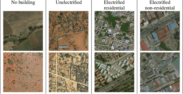

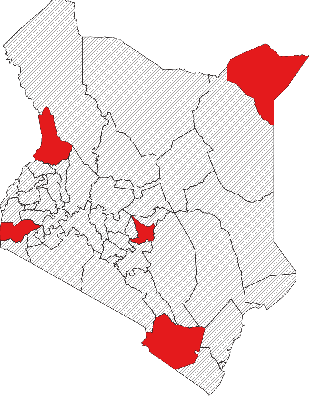
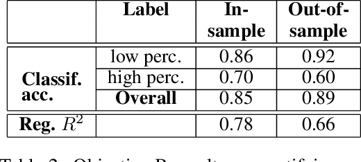
Abstract:Governments and international organizations the world over are investing towards the goal of achieving universal energy access for improving socio-economic development. However, in developing settings, monitoring electrification efforts is typically inaccurate, infrequent, and expensive. In this work, we develop and present techniques for high-resolution monitoring of electrification progress at scale. Specifically, our 3 unique contributions are: (i) identifying areas with(out) electricity access, (ii) quantifying the extent of electrification in electrified areas (percentage/number of electrified structures), and (iii) differentiating between customer types in electrified regions (estimating the percentage/number of residential/non-residential electrified structures). We combine high-resolution 50 cm daytime satellite images with Convolutional Neural Networks (CNNs) to train a series of classification and regression models. We evaluate our models using unique ground truth datasets on building locations, building types (residential/non-residential), and building electrification status. Our classification models show a 92% accuracy in identifying electrified regions, 85% accuracy in estimating percent of (low/high) electrified buildings within the region, and 69% accuracy in differentiating between (low/high) percentage of electrified residential buildings. Our regressions show $R^2$ scores of 78% and 80% in estimating the number of electrified buildings and number of residential electrified building in images respectively. We also demonstrate the generalizability of our models in never-before-seen regions to assess their potential for consistent and high-resolution measurements of electrification in emerging economies, and conclude by highlighting opportunities for improvement.
Predicting Levels of Household Electricity Consumption in Low-Access Settings
Dec 15, 2021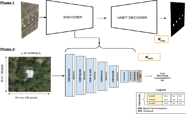
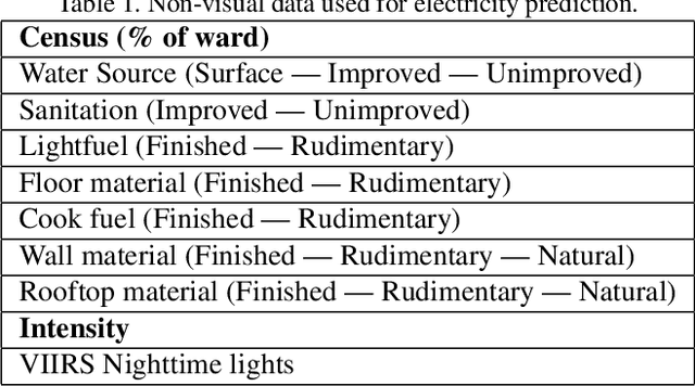

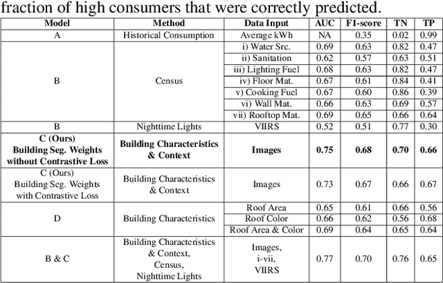
Abstract:In low-income settings, the most critical piece of information for electric utilities is the anticipated consumption of a customer. Electricity consumption assessment is difficult to do in settings where a significant fraction of households do not yet have an electricity connection. In such settings the absolute levels of anticipated consumption can range from 5-100 kWh/month, leading to high variability amongst these customers. Precious resources are at stake if a significant fraction of low consumers are connected over those with higher consumption. This is the first study of it's kind in low-income settings that attempts to predict a building's consumption and not that of an aggregate administrative area. We train a Convolutional Neural Network (CNN) over pre-electrification daytime satellite imagery with a sample of utility bills from 20,000 geo-referenced electricity customers in Kenya (0.01% of Kenya's residential customers). This is made possible with a two-stage approach that uses a novel building segmentation approach to leverage much larger volumes of no-cost satellite imagery to make the most of scarce and expensive customer data. Our method shows that competitive accuracies can be achieved at the building level, addressing the challenge of consumption variability. This work shows that the building's characteristics and it's surrounding context are both important in predicting consumption levels. We also evaluate the addition of lower resolution geospatial datasets into the training process, including nighttime lights and census-derived data. The results are already helping inform site selection and distribution-level planning, through granular predictions at the level of individual structures in Kenya and there is no reason this cannot be extended to other countries.
Assigning a Grade: Accurate Measurement of Road Quality Using Satellite Imagery
Dec 06, 2018
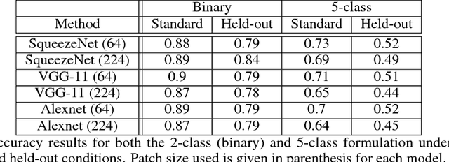
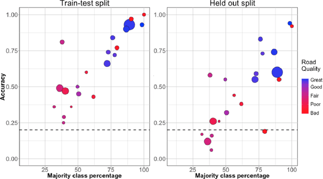
Abstract:Roads are critically important infrastructure to societal and economic development, with huge investments made by governments every year. However, methods for monitoring those investments tend to be time-consuming, laborious, and expensive, placing them out of reach for many developing regions. In this work, we develop a model for monitoring the quality of road infrastructure using satellite imagery. For this task, we harness two trends: the increasing availability of high-resolution, often-updated satellite imagery, and the enormous improvement in speed and accuracy of convolutional neural network-based methods for performing computer vision tasks. We employ a unique dataset of road quality information on 7000km of roads in Kenya combined with 50cm resolution satellite imagery. We create models for a binary classification task as well as a comprehensive 5-category classification task, with accuracy scores of 88 and 73 percent respectively. We also provide evidence of the robustness of our methods with challenging held-out scenarios, though we note some improvement is still required for confident analysis of a never before seen road. We believe these results are well-positioned to have substantial impact on a broad set of transport applications.
Energy-Efficient Building HVAC Control Using Hybrid System LBMPC
Apr 20, 2012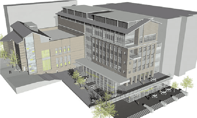
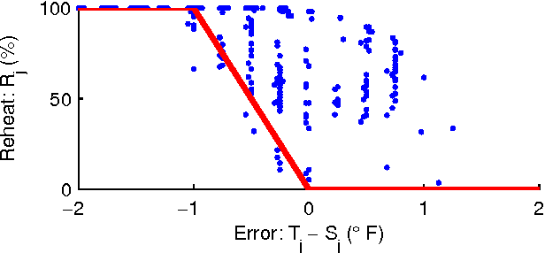

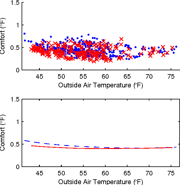
Abstract:Improving the energy-efficiency of heating, ventilation, and air-conditioning (HVAC) systems has the potential to realize large economic and societal benefits. This paper concerns the system identification of a hybrid system model of a building-wide HVAC system and its subsequent control using a hybrid system formulation of learning-based model predictive control (LBMPC). Here, the learning refers to model updates to the hybrid system model that incorporate the heating effects due to occupancy, solar effects, outside air temperature (OAT), and equipment, in addition to integrator dynamics inherently present in low-level control. Though we make significant modeling simplifications, our corresponding controller that uses this model is able to experimentally achieve a large reduction in energy usage without any degradations in occupant comfort. It is in this way that we justify the modeling simplifications that we have made. We conclude by presenting results from experiments on our building HVAC testbed, which show an average of 1.5MWh of energy savings per day (p = 0.002) with a 95% confidence interval of 1.0MWh to 2.1MWh of energy savings.
 Add to Chrome
 Add to Firefox
 Add to Edge