Zeal Shah
A Higher Purpose: Measuring Electricity Access Using High-Resolution Daytime Satellite Imagery
Oct 08, 2022


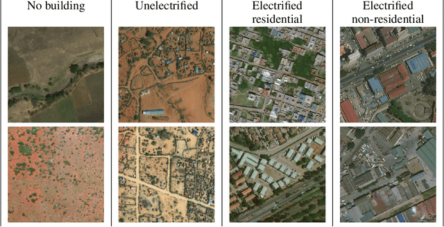
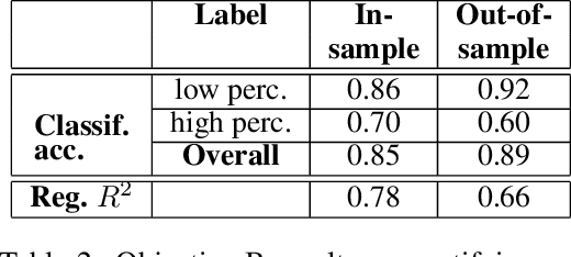
Abstract:Governments and international organizations the world over are investing towards the goal of achieving universal energy access for improving socio-economic development. However, in developing settings, monitoring electrification efforts is typically inaccurate, infrequent, and expensive. In this work, we develop and present techniques for high-resolution monitoring of electrification progress at scale. Specifically, our 3 unique contributions are: (i) identifying areas with(out) electricity access, (ii) quantifying the extent of electrification in electrified areas (percentage/number of electrified structures), and (iii) differentiating between customer types in electrified regions (estimating the percentage/number of residential/non-residential electrified structures). We combine high-resolution 50 cm daytime satellite images with Convolutional Neural Networks (CNNs) to train a series of classification and regression models. We evaluate our models using unique ground truth datasets on building locations, building types (residential/non-residential), and building electrification status. Our classification models show a 92% accuracy in identifying electrified regions, 85% accuracy in estimating percent of (low/high) electrified buildings within the region, and 69% accuracy in differentiating between (low/high) percentage of electrified residential buildings. Our regressions show $R^2$ scores of 78% and 80% in estimating the number of electrified buildings and number of residential electrified building in images respectively. We also demonstrate the generalizability of our models in never-before-seen regions to assess their potential for consistent and high-resolution measurements of electrification in emerging economies, and conclude by highlighting opportunities for improvement.
 Add to Chrome
 Add to Firefox
 Add to Edge