Jashandeep Singh
Developing a novel fair-loan-predictor through a multi-sensitive debiasing pipeline: DualFair
Oct 27, 2021


Abstract:Machine learning (ML) models are increasingly used for high-stake applications that can greatly impact people's lives. Despite their use, these models have the potential to be biased towards certain social groups on the basis of race, gender, or ethnicity. Many prior works have attempted to mitigate this "model discrimination" by updating the training data (pre-processing), altering the model learning process (in-processing), or manipulating model output (post-processing). However, these works have not yet been extended to the realm of multi-sensitive parameters and sensitive options (MSPSO), where sensitive parameters are attributes that can be discriminated against (e.g race) and sensitive options are options within sensitive parameters (e.g black or white), thus giving them limited real-world usability. Prior work in fairness has also suffered from an accuracy-fairness tradeoff that prevents both the accuracy and fairness from being high. Moreover, previous literature has failed to provide holistic fairness metrics that work with MSPSO. In this paper, we solve all three of these problems by (a) creating a novel bias mitigation technique called DualFair and (b) developing a new fairness metric (i.e. AWI) that can handle MSPSO. Lastly, we test our novel mitigation method using a comprehensive U.S mortgage lending dataset and show that our classifier, or fair loan predictor, obtains better fairness and accuracy metrics than current state-of-the-art models.
Bird-Area Water-Bodies Dataset and Predictive AI Model for Avian Botulism Outbreak
May 03, 2021


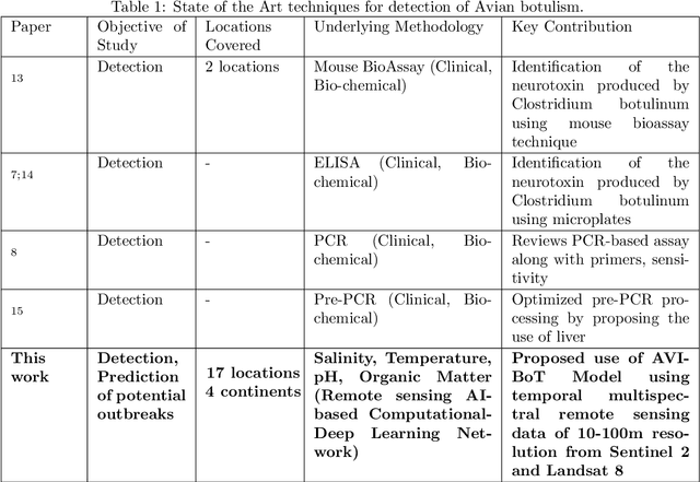
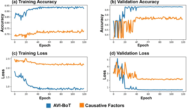
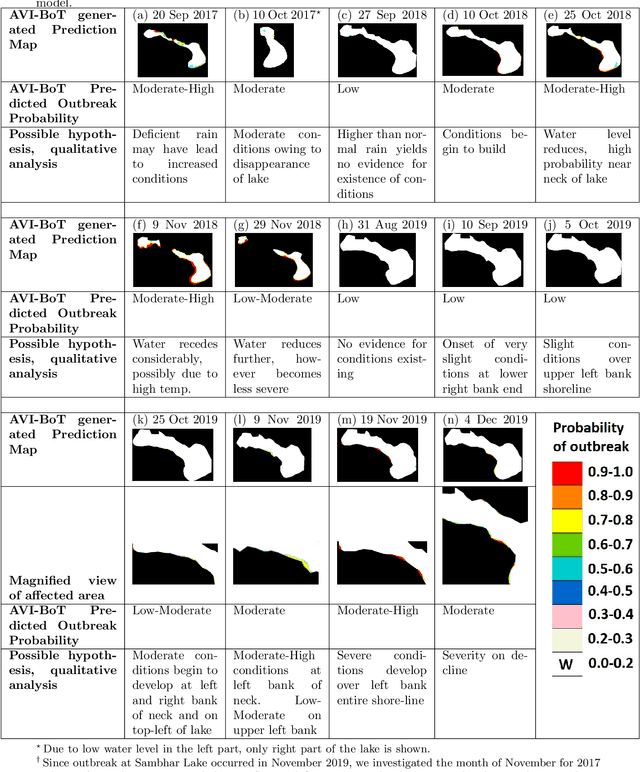
Abstract:Avian botulism caused by a bacterium, Clostridium botulinum, causes a paralytic disease in birds often leading to high fatality, and is usually diagnosed using molecular techniques. Diagnostic techniques for Avian botulism include: Mouse Bioassay, ELISA, PCR, all of which are time-consuming, laborious and require invasive sample collection from affected sites. In this study, we build a first-ever multi-spectral, remote-sensing imagery based global Bird-Area Water-bodies Dataset (BAWD) (i.e. fused satellite images of water-body sites important for avian fauna) backed by on-ground reporting evidence of outbreaks. In the current version, BAWD covers a total ground area of 904 sq.km from two open source satellite projects (Sentinel and Landsat). BAWD consists of 17 topographically diverse global sites spanning across 4 continents, with locations monitored over a time-span of 3 years (2016-2020). Using BAWD and state-of-the-art deep-learning techniques we propose a first-ever Artificial Intelligence based (AI) model to predict potential outbreak of Avian botulism called AVI-BoT (Aerosol, Visible, Infra-red (NIR/SWIR) and Bands of Thermal). AVI-BoT uses fused multi-spectral satellite images of water-bodies (10-bands) as input to generate a spatial prediction map depicting probability of potential Avian botulism outbreaks. We also train and investigate a simpler (5-band) Causative-Factor model (based on prominent physiological factors reported in literature as conducive for outbreak) to predict Avian botulism. Using AVI-BoT, we achieve a training accuracy of 0.94 and validation accuracy of 0.96 on BAWD, far superior in comparison to our Causative factors model. The proposed technique presents a scale-able, low-cost, non-invasive methodology for continuous monitoring of bird-habitats against botulism outbreaks with the potential of saving valuable fauna lives.
 Add to Chrome
 Add to Firefox
 Add to Edge