Devang Mahesh
Bird-Area Water-Bodies Dataset and Predictive AI Model for Avian Botulism Outbreak
May 03, 2021


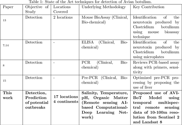
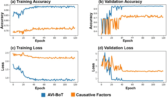
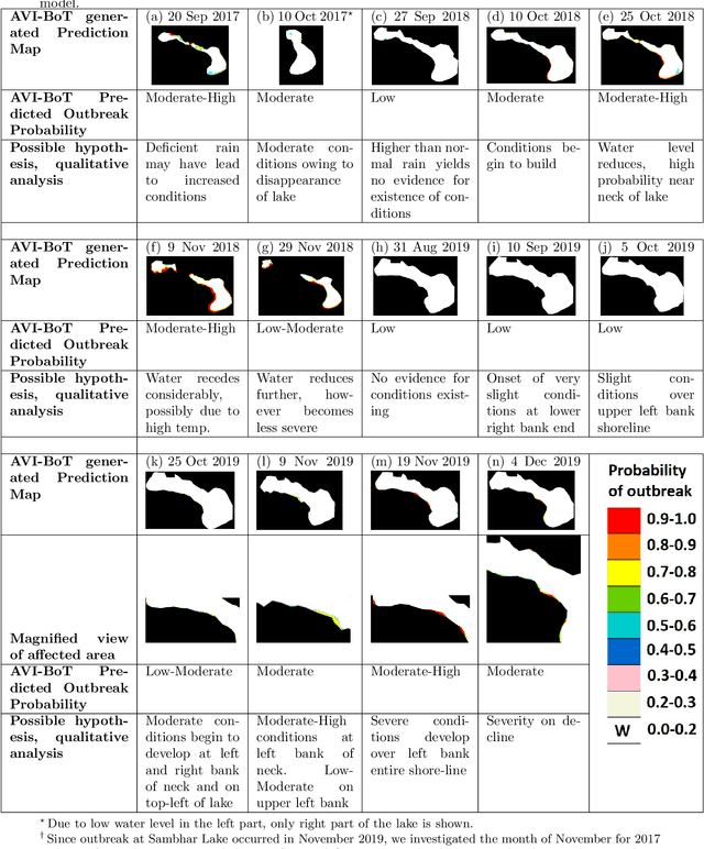
Abstract:Avian botulism caused by a bacterium, Clostridium botulinum, causes a paralytic disease in birds often leading to high fatality, and is usually diagnosed using molecular techniques. Diagnostic techniques for Avian botulism include: Mouse Bioassay, ELISA, PCR, all of which are time-consuming, laborious and require invasive sample collection from affected sites. In this study, we build a first-ever multi-spectral, remote-sensing imagery based global Bird-Area Water-bodies Dataset (BAWD) (i.e. fused satellite images of water-body sites important for avian fauna) backed by on-ground reporting evidence of outbreaks. In the current version, BAWD covers a total ground area of 904 sq.km from two open source satellite projects (Sentinel and Landsat). BAWD consists of 17 topographically diverse global sites spanning across 4 continents, with locations monitored over a time-span of 3 years (2016-2020). Using BAWD and state-of-the-art deep-learning techniques we propose a first-ever Artificial Intelligence based (AI) model to predict potential outbreak of Avian botulism called AVI-BoT (Aerosol, Visible, Infra-red (NIR/SWIR) and Bands of Thermal). AVI-BoT uses fused multi-spectral satellite images of water-bodies (10-bands) as input to generate a spatial prediction map depicting probability of potential Avian botulism outbreaks. We also train and investigate a simpler (5-band) Causative-Factor model (based on prominent physiological factors reported in literature as conducive for outbreak) to predict Avian botulism. Using AVI-BoT, we achieve a training accuracy of 0.94 and validation accuracy of 0.96 on BAWD, far superior in comparison to our Causative factors model. The proposed technique presents a scale-able, low-cost, non-invasive methodology for continuous monitoring of bird-habitats against botulism outbreaks with the potential of saving valuable fauna lives.
 Add to Chrome
 Add to Firefox
 Add to Edge