 Add to Chrome
 Add to Firefox
 Add to Edge
OpenGERT: Open Source Automated Geometry Extraction with Geometric and Electromagnetic Sensitivity Analyses for Ray-Tracing Propagation Models
Jan 12, 2025


Accurate RF propagation modeling in urban environments is critical for developing digital spectrum twins and optimizing wireless communication systems. We introduce OpenGERT, an open-source automated Geometry Extraction tool for Ray Tracing, which collects and processes terrain and building data from OpenStreetMap, Microsoft Global ML Building Footprints, and USGS elevation data. Using the Blender Python API, it creates detailed urban models for high-fidelity simulations with NVIDIA Sionna RT. We perform sensitivity analyses to examine how variations in building height, position, and electromagnetic material properties affect ray-tracing accuracy. Specifically, we present pairwise dispersion plots of channel statistics (path gain, mean excess delay, delay spread, link outage, and Rician K-factor) and investigate how their sensitivities change with distance from transmitters. We also visualize the variance of these statistics for selected transmitter locations to gain deeper insights. Our study covers Munich and Etoile scenes, each with 10 transmitter locations. For each location, we apply five types of perturbations: material, position, height, height-position, and all combined, with 50 perturbations each. Results show that small changes in permittivity and conductivity minimally affect channel statistics, whereas variations in building height and position significantly alter all statistics, even with noise standard deviations of 1 meter in height and 0.4 meters in position. These findings highlight the importance of precise environmental modeling for accurate propagation predictions, essential for digital spectrum twins and advanced communication networks. The code for geometry extraction and sensitivity analyses is available at github.com/serhatadik/OpenGERT/.
FlexRDZ: Autonomous Mobility Management for Radio Dynamic Zones
Sep 04, 2023


FlexRDZ is an online, autonomous manager for radio dynamic zones (RDZ) that seeks to enable the safe operation of RDZs through real-time control of deployed test transmitters. FlexRDZ leverages Hierarchical Task Networks and digital twin modeling to plan and resolve RDZ violations in near real-time. We prototype FlexRDZ with GTPyhop and the Terrain Integrated Rough Earth Model (TIREM). We deploy and evaluate FlexRDZ within a simulated version of the Salt Lake City POWDER testbed, a potential urban RDZ environment. Our simulations show that FlexRDZ enables up to a 20 dBm reduction in mobile interference and a significant reduction in the total power of leaked transmissions while preserving the overall communication capabilities and uptime of test transmitters. To our knowledge, FlexRDZ is the first autonomous system for RDZ management.
Practical and Configurable Network Traffic Classification Using Probabilistic Machine Learning
Jul 10, 2021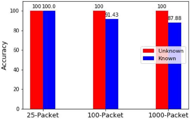
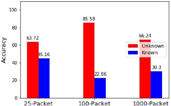


Network traffic classification that is widely applicable and highly accurate is valuable for many network security and management tasks. A flexible and easily configurable classification framework is ideal, as it can be customized for use in a wide variety of networks. In this paper, we propose a highly configurable and flexible machine learning traffic classification method that relies only on statistics of sequences of packets to distinguish known, or approved, traffic from unknown traffic. Our method is based on likelihood estimation, provides a measure of certainty for classification decisions, and can classify traffic at adjustable certainty levels. Our classification method can also be applied in different classification scenarios, each prioritizing a different classification goal. We demonstrate how our classification scheme and all its configurations perform well on real-world traffic from a high performance computing network environment.