Hariharan Ramshankar
Real-world Mapping of Gaze Fixations Using Instance Segmentation for Road Construction Safety Applications
Feb 01, 2019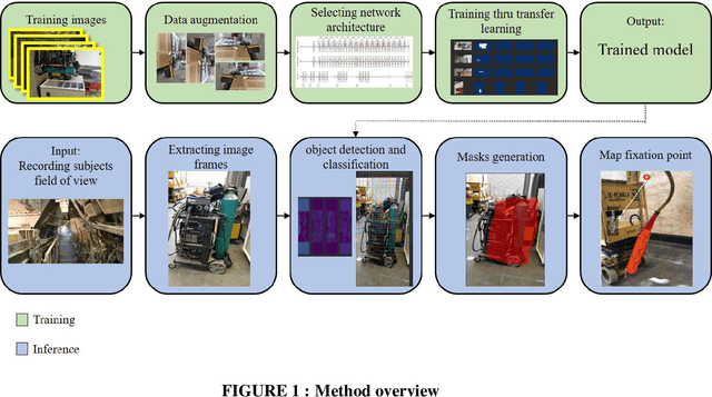

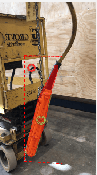

Abstract:Research studies have shown that a large proportion of hazards remain unrecognized, which expose construction workers to unanticipated safety risks. Recent studies have also found that a strong correlation exists between viewing patterns of workers, captured using eye-tracking devices, and their hazard recognition performance. Therefore, it is important to analyze the viewing patterns of workers to gain a better understanding of their hazard recognition performance. This paper proposes a method that can automatically map the gaze fixations collected using a wearable eye-tracker to the predefined areas of interests. The proposed method detects these areas or objects (i.e., hazards) of interests through a computer vision-based segmentation technique and transfer learning. The mapped fixation data is then used to analyze the viewing behaviors of workers and compute their attention distribution. The proposed method is implemented on an under construction road as a case study to evaluate the performance of the proposed method.
Building an Integrated Mobile Robotic System for Real-Time Applications in Construction
Apr 18, 2018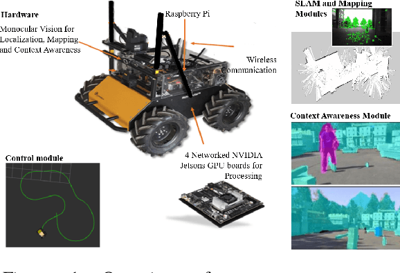

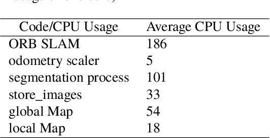
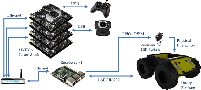
Abstract:One of the major challenges of a real-time autonomous robotic system for construction monitoring is to simultaneously localize, map, and navigate over the lifetime of the robot, with little or no human intervention. Past research on Simultaneous Localization and Mapping (SLAM) and context-awareness are two active research areas in the computer vision and robotics communities. The studies that integrate both in real-time into a single modular framework for construction monitoring still need further investigation. A monocular vision system and real-time scene understanding are computationally heavy and the major state-of-the-art algorithms are tested on high-end desktops and/or servers with a high CPU- and/or GPU- computing capabilities, which affect their mobility and deployment for real-world applications. To address these challenges and achieve automation, this paper proposes an integrated robotic computer vision system, which generates a real-world spatial map of the obstacles and traversable space present in the environment in near real-time. This is done by integrating contextual Awareness and visual SLAM into a ground robotics agent. This paper presents the hardware utilization and performance of the aforementioned system for three different outdoor environments, which represent the applicability of this pipeline to diverse outdoor scenes in near real-time. The entire system is also self-contained and does not require user input, which demonstrates the potential of this computer vision system for autonomous navigation.
 Add to Chrome
 Add to Firefox
 Add to Edge