Hai-Han Sun
A Near-Field Super-Resolution Network for Accelerating Antenna Characterization
Jun 25, 2024Abstract:We present a deep neural network-enabled method to accelerate near-field (NF) antenna measurement. We develop a Near-field Super-resolution Network (NFS-Net) to reconstruct significantly undersampled near-field data as high-resolution data, which considerably reduces the number of sampling points required for NF measurement and thus improves measurement efficiency. The high-resolution near-field data reconstructed by the network is further processed by a near-field-to-far-field (NF2FF) transformation to obtain far-field antenna radiation patterns. Our experiments demonstrate that the NFS-Net exhibits both accuracy and generalizability in restoring high-resolution near-field data from low-resolution input. The NF measurement workflow that combines the NFS-Net and the NF2FF algorithm enables accurate radiation pattern characterization with only 11% of the Nyquist rate samples. Though the experiments in this study are conducted on a planar setup with a uniform grid, the proposed method can serve as a universal strategy to accelerate measurements under different setups and conditions.
3DInvNet: A Deep Learning-Based 3D Ground-Penetrating Radar Data Inversion
May 09, 2023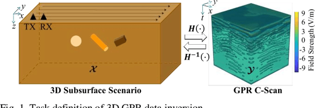
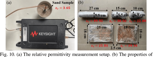
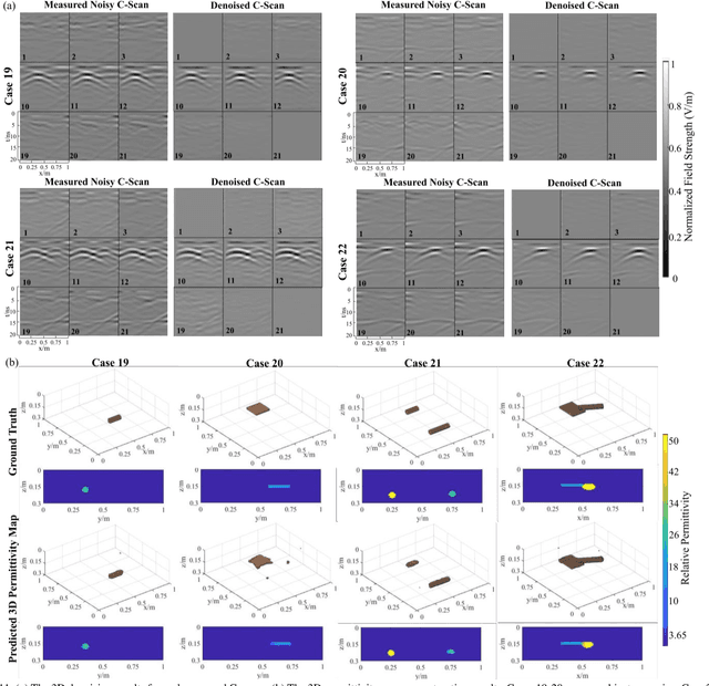
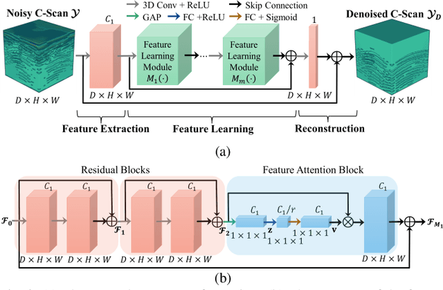
Abstract:The reconstruction of the 3D permittivity map from ground-penetrating radar (GPR) data is of great importance for mapping subsurface environments and inspecting underground structural integrity. Traditional iterative 3D reconstruction algorithms suffer from strong non-linearity, ill-posedness, and high computational cost. To tackle these issues, a 3D deep learning scheme, called 3DInvNet, is proposed to reconstruct 3D permittivity maps from GPR C-scans. The proposed scheme leverages a prior 3D convolutional neural network with a feature attention mechanism to suppress the noise in the C-scans due to subsurface heterogeneous soil environments. Then a 3D U-shaped encoder-decoder network with multi-scale feature aggregation modules is designed to establish the optimal inverse mapping from the denoised C-scans to 3D permittivity maps. Furthermore, a three-step separate learning strategy is employed to pre-train and fine-tune the networks. The proposed scheme is applied to numerical simulation as well as real measurement data. The quantitative and qualitative results show the network capability, generalizability, and robustness in denoising GPR C-scans and reconstructing 3D permittivity maps of subsurface objects.
Diameter Estimation of Cylindrical Metal Bar Using Wideband Dual-Polarized Ground-Penetrating Radar
Dec 26, 2022


Abstract:Ground-penetrating radar (GPR) has been an effective technology for locating metal bars in civil engineering structures. However, the accurate sizing of subsurface metal bars of small diameters remains a challenging problem for the existing reflection pattern-based method due to the limited resolution of GPR. To address the issue, we propose a reflection power-based method by exploring the relationship between the bar diameter and the maximum power of the bar reflected signal obtained by a wideband dual-polarized GPR, which circumvents the resolution limit of the existing pattern-based method. In the proposed method, the theoretical relationship between the bar diameter and the power ratio of the bar reflected signals acquired by perpendicular and parallel polarized antennas is established via the inherent scattering width of the metal bar and the wideband spectrum of the bar reflected signal. Based on the theoretical relationship, the bar diameter can be estimated using the obtained power ratio in a GPR survey. Simulations and experiments have been conducted with different GPR frequency spectra, subsurface mediums, and metal bars of various diameters and depths to demonstrate the efficacy of the method. Experimental results show that the method achieves high sizing accuracy with errors of less than 10% in different scenarios. With its simple operation and high accuracy, the method can be implemented in real-time in situ examination of subsurface metal bars.
A Deep Learning-Based GPR Forward Solver for Predicting B-Scans of Subsurface Objects
Jul 13, 2022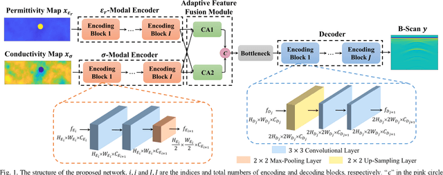
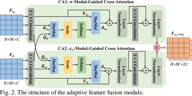

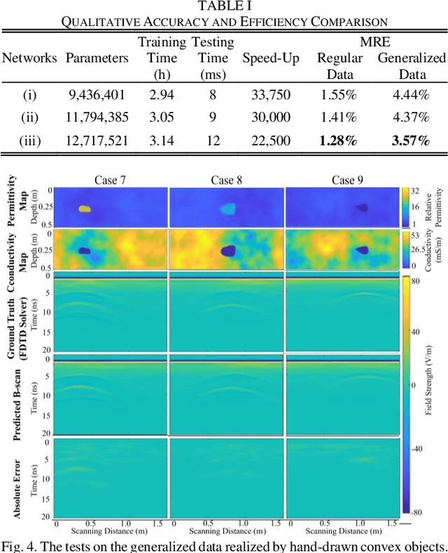
Abstract:The forward full-wave modeling of ground-penetrating radar (GPR) facilitates the understanding and interpretation of GPR data. Traditional forward solvers require excessive computational resources, especially when their repetitive executions are needed in signal processing and/or machine learning algorithms for GPR data inversion. To alleviate the computational burden, a deep learning-based 2D GPR forward solver is proposed to predict the GPR B-scans of subsurface objects buried in the heterogeneous soil. The proposed solver is constructed as a bimodal encoder-decoder neural network. Two encoders followed by an adaptive feature fusion module are designed to extract informative features from the subsurface permittivity and conductivity maps. The decoder subsequently constructs the B-scans from the fused feature representations. To enhance the network's generalization capability, transfer learning is employed to fine-tune the network for new scenarios vastly different from those in training set. Numerical results show that the proposed solver achieves a mean relative error of 1.28%. For predicting the B-scan of one subsurface object, the proposed solver requires 12 milliseconds, which is 22,500x less than the time required by a classical physics-based solver.
Dual-Cross-Polarized GPR Measurement Method for Detection and Orientation Estimation of Shallowly Buried Elongated Object
May 17, 2022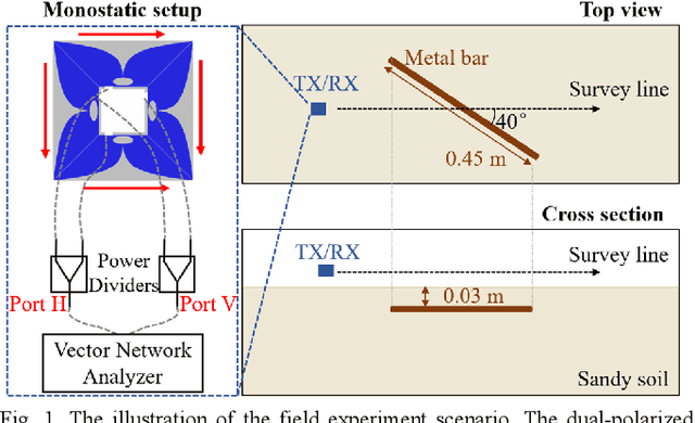
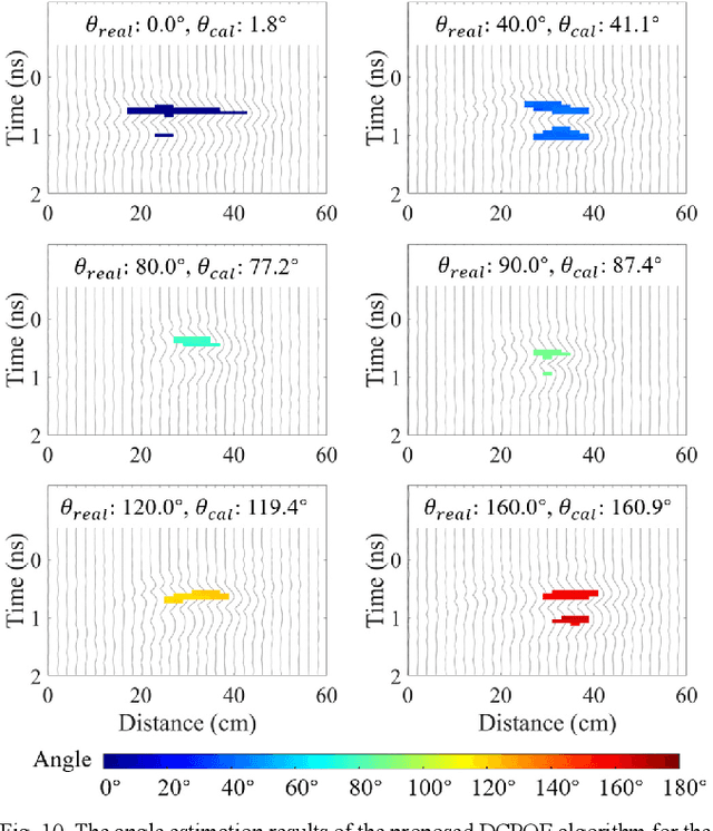

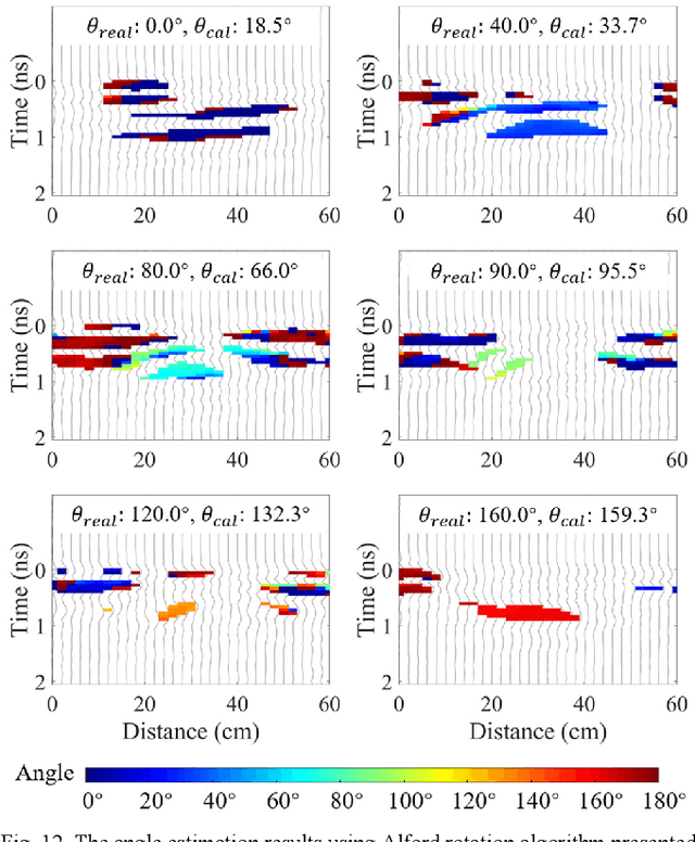
Abstract:Detecting a shallowly buried and elongated object and estimating its orientation using a commonly adopted co-polarized GPR system is challenging due to the presence of strong ground clutter that masks the target reflection. A cross-polarized configuration can be used to suppress ground clutter and reveal the object reflection, but it suffers from inconsistent detection capability which significantly varies with different object orientations. To address this issue, we propose a dual-cross-polarized detection (DCPD) method which utilizes two cross-polarized antennas with a special arrangement to detect the object. The signals reflected by the object and collected by the two antennas are combined in a rotationally invariant manner to ensure both effective ground clutter suppression and consistent detection irrespective of the object orientation. In addition, we present a dual-cross-polarized orientation estimation (DCPOE) algorithm to estimate the object orientation from the two cross-polarized data. The proposed DCPOE algorithm is less affected by environmental noise and performs robust and accurate azimuth angle estimation. The effectiveness of the proposed techniques in the detection and orientation estimation and their advantages over the existing method have been demonstrated using experimental data. Comparison results show that the maximum and average errors are 22.3{\deg} and 10.9{\deg} for the Alford rotation algorithm, while those are 4.9{\deg} and 1.8{\deg} for the proposed DCPOE algorithm in the demonstrated shallowly buried object cases. The proposed techniques can be unified in a framework to facilitate the investigation and mapping of shallowly buried and elongated targets.
Learning to Remove Clutter in Real-World GPR Images Using Hybrid Data
May 17, 2022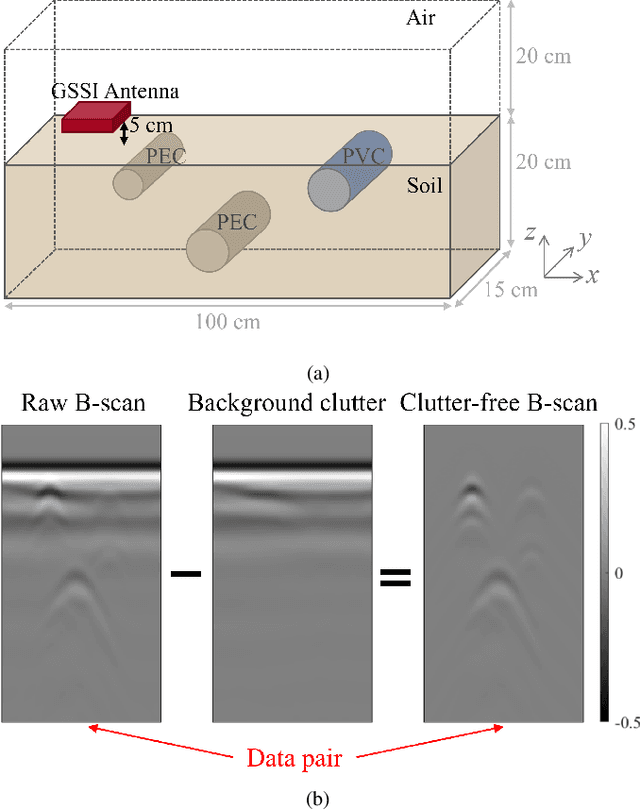

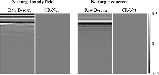
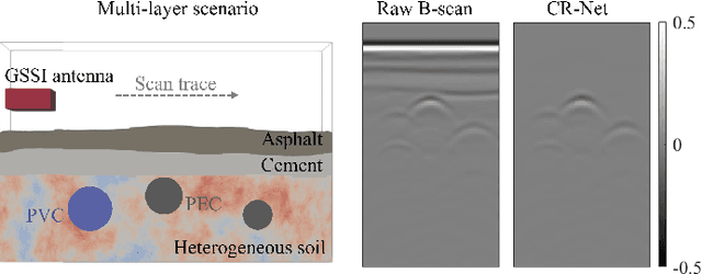
Abstract:The clutter in the ground-penetrating radar (GPR) radargram disguises or distorts subsurface target responses, which severely affects the accuracy of target detection and identification. Existing clutter removal methods either leave residual clutter or deform target responses when facing complex and irregular clutter in the real-world radargram. To tackle the challenge of clutter removal in real scenarios, a clutter-removal neural network (CR-Net) trained on a large-scale hybrid dataset is presented in this study. The CR-Net integrates residual dense blocks into the U-Net architecture to enhance its capability in clutter suppression and target reflection restoration. The combination of the mean absolute error (MAE) loss and the multi-scale structural similarity (MS-SSIM) loss is used to effectively drive the optimization of the network. To train the proposed CR-Net to remove complex and diverse clutter in real-world radargrams, the first large-scale hybrid dataset named CLT-GPR dataset containing clutter collected by different GPR systems in multiple scenarios is built. The CLT-GPR dataset significantly improves the generalizability of the network to remove clutter in real-world GPR radargrams. Extensive experimental results demonstrate that the CR-Net achieves superior performance over existing methods in removing clutter and restoring target responses in diverse real-world scenarios. Moreover, the CR-Net with its end-to-end design does not require manual parameter tuning, making it highly suitable for automatically producing clutter-free radargrams in GPR applications. The CLT-GPR dataset and the code implemented in the paper can be found at https://haihan-sun.github.io/GPR.html.
DMRF-UNet: A Two-Stage Deep Learning Scheme for GPR Data Inversion under Heterogeneous Soil Conditions
May 16, 2022


Abstract:Traditional ground-penetrating radar (GPR) data inversion leverages iterative algorithms which suffer from high computation costs and low accuracy when applied to complex subsurface scenarios. Existing deep learning-based methods focus on the ideal homogeneous subsurface environments and ignore the interference due to clutters and noise in real-world heterogeneous environments. To address these issues, a two-stage deep neural network (DNN), called DMRF-UNet, is proposed to reconstruct the permittivity distributions of subsurface objects from GPR B-scans under heterogeneous soil conditions. In the first stage, a U-shape DNN with multi-receptive-field convolutions (MRF-UNet1) is built to remove the clutters due to inhomogeneity of the heterogeneous soil. Then the denoised B-scan from the MRF-UNet1 is combined with the noisy B-scan to be inputted to the DNN in the second stage (MRF-UNet2). The MRF-UNet2 learns the inverse mapping relationship and reconstructs the permittivity distribution of subsurface objects. To avoid information loss, an end-to-end training method combining the loss functions of two stages is introduced. A wide range of subsurface heterogeneous scenarios and B-scans are generated to evaluate the inversion performance. The test results in the numerical experiment and the real measurement show that the proposed network reconstructs the permittivities, shapes, sizes, and locations of subsurface objects with high accuracy. The comparison with existing methods demonstrates the superiority of the proposed methodology for the inversion under heterogeneous soil conditions.
Estimating Parameters of the Tree Root in Heterogeneous Soil Environments via Mask-Guided Multi-Polarimetric Integration Neural Network
Dec 27, 2021


Abstract:Ground-penetrating radar (GPR) has been used as a non-destructive tool for tree root inspection. Estimating root-related parameters from GPR radargrams greatly facilitates root health monitoring and imaging. However, the task of estimating root-related parameters is challenging as the root reflection is a complex function of multiple root parameters and root orientations. Existing methods can only estimate a single root parameter at a time without considering the influence of other parameters and root orientations, resulting in limited estimation accuracy under different root conditions. In addition, soil heterogeneity introduces clutter in GPR radargrams, making the data processing and interpretation even harder. To address these issues, a novel neural network architecture, called mask-guided multi-polarimetric integration neural network (MMI-Net), is proposed to automatically and simultaneously estimate multiple root-related parameters in heterogeneous soil environments. The MMI-Net includes two sub-networks: a MaskNet that predicts a mask to highlight the root reflection area to eliminate interfering environmental clutter, and a ParaNet that uses the predicted mask as guidance to integrate, extract, and emphasize informative features in multi-polarimetric radargrams for accurate estimation of five key root-related parameters. The parameters include the root depth, diameter, relative permittivity, horizontal and vertical orientation angles. Experimental results demonstrate that the proposed MMI-Net achieves high estimation accuracy in these root-related parameters. This is the first work that takes the combined contributions of root parameters and spatial orientations into account and simultaneously estimates multiple root-related parameters. The data and code implemented in the paper can be found at https://haihan-sun.github.io/GPR.html.
The Orientation Estimation of Elongated Underground Objects via Multi-Polarization Aggregation and Selection Neural Network
Jan 29, 2021


Abstract:The horizontal orientation angle and vertical inclination angle of an elongated subsurface object are key parameters for object identification and imaging in ground penetration radar (GPR) applications. Conventional methods can only extract the horizontal orientation angle or estimate both angles in narrow ranges due to limited polarimetric information and detection capability. To address these issues, this letter, for the first time, explores the possibility of leveraging neural networks with multi-polarimetric GPR data to estimate both angles of an elongated subsurface object in the entire spatial range. Based on the polarization-sensitive characteristic of an elongated object, we propose a multi-polarization aggregation and selection neural network (MASNet), which takes the multi-polarimetric radargrams as inputs, integrates their characteristics in the feature space, and selects discriminative features of reflected signal patterns for accurate orientation estimation. Numerical results show that our proposed MASNet achieves high estimation accuracy with an angle estimation error of less than 5{\deg}, which outperforms conventional methods by a large margin. The promising results obtained by the proposed method encourages one to think of new solutions for GPR related tasks by integrating multi-polarization information with deep learning techniques.
 Add to Chrome
 Add to Firefox
 Add to Edge