Emily Schultz-Fellenz
Globally Optimal Boresight Alignment of UAV-LiDAR Systems
Feb 28, 2022


Abstract:In airborne light detection and ranging (LiDAR) systems, misalignments between the LiDAR-scanner and the inertial navigation system (INS) mounted on an unmanned aerial vehicle (UAV)'s frame can lead to inaccurate 3D point clouds. Determining the orientation offset, or boresight error is key to many LiDAR-based applications. In this work, we introduce a mixed-integer quadratically constrained quadratic program (MIQCQP) that can globally solve this misalignment problem. We also propose a nested spatial branch and bound (nsBB) algorithm that improves computational performance. The nsBB relies on novel preprocessing steps that progressively reduce the problem size. In addition, an adaptive grid search (aGS) allowing us to obtain quick heuristic solutions is presented. Our algorithms are open-source, multi-threaded and multi-machine compatible.
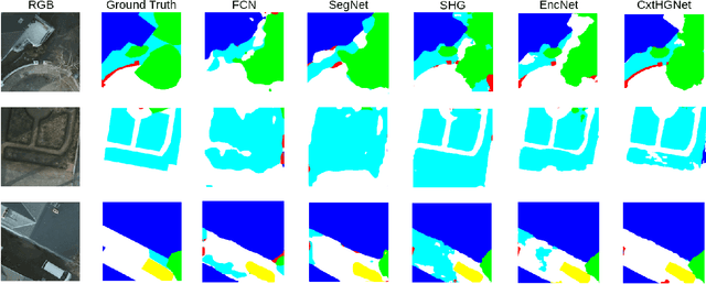
Encoded Hourglass Network for Semantic Segmentation of High Resolution Aerial Imagery
Oct 30, 2018


Abstract:Fully Convolutional Network (FCN) has been widely used in recent work for semantic segmentation of high resolution aerial imagery. However, FCN is poor at extracting multi-scale features and exploiting contextual information. In this paper, we explore stacked encoder-decoder structure which enables repeated bottom-up, top-down inference across various scales and consolidates global and local information of the image. Moreover, we utilize the Context Encoding Module to capture the global contextual semantics of scenes and selectively emphasize or de-emphasize class-dependent featuremaps. Our approach is further enhanced by intermediate supervision on the predictions of multiple decoders and has achieved 87.01% pixel accuracy and 69.78% mIoU on Potsdam test set, which surpasses various baseline models.
 Add to Chrome
 Add to Firefox
 Add to Edge