Dylan Stewart
Image-to-Height Domain Translation for Synthetic Aperture Sonar
Dec 12, 2021


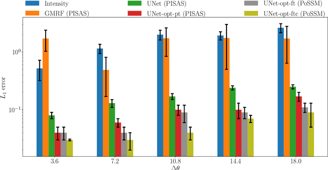
Abstract:Observations of seabed texture with synthetic aperture sonar are dependent upon several factors. In this work, we focus on collection geometry with respect to isotropic and anisotropic textures. The low grazing angle of the collection geometry, combined with orientation of the sonar path relative to anisotropic texture, poses a significant challenge for image-alignment and other multi-view scene understanding frameworks. We previously proposed using features captured from estimated seabed relief to improve scene understanding. While several methods have been developed to estimate seabed relief via intensity, no large-scale study exists in the literature. Furthermore, a dataset of coregistered seabed relief maps and sonar imagery is nonexistent to learn this domain translation. We address these problems by producing a large simulated dataset containing coregistered pairs of seabed relief and intensity maps from two unique sonar data simulation techniques. We apply three types of models, with varying complexity, to translate intensity imagery to seabed relief: a Gaussian Markov Random Field approach (GMRF), a conditional Generative Adversarial Network (cGAN), and UNet architectures. Methods are compared in reference to the coregistered simulated datasets using L1 error. Additionally, predictions on simulated and real SAS imagery are shown. Finally, models are compared on two datasets of hand-aligned SAS imagery and evaluated in terms of L1 error across multiple aspects in comparison to using intensity. Our comprehensive experiments show that the proposed UNet architectures outperform the GMRF and pix2pix cGAN models on seabed relief estimation for simulated and real SAS imagery.
Learnable Adaptive Cosine Estimator (LACE) for Image Classification
Oct 15, 2021


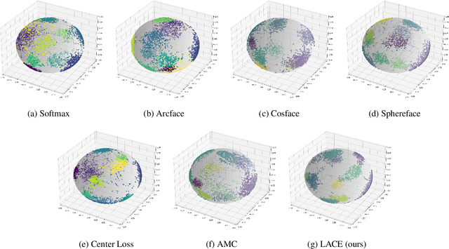
Abstract:In this work, we propose a new loss to improve feature discriminability and classification performance. Motivated by the adaptive cosine/coherence estimator (ACE), our proposed method incorporates angular information that is inherently learned by artificial neural networks. Our learnable ACE (LACE) transforms the data into a new "whitened" space that improves the inter-class separability and intra-class compactness. We compare our LACE to alternative state-of-the art softmax-based and feature regularization approaches. Our results show that the proposed method can serve as a viable alternative to cross entropy and angular softmax approaches. Our code is publicly available: https://github.com/GatorSense/LACE.
Addressing Annotation Imprecision for Tree Crown Delineation Using the RandCrowns Index
May 05, 2021


Abstract:Supervised methods for object delineation in remote sensing require labeled ground-truth data. Gathering sufficient high quality ground-truth data is difficult, especially when the targets are of irregular shape or difficult to distinguish from the background or neighboring objects. Tree crown delineation provides key information from remote sensing images for forestry, ecology, and management. However, tree crowns in remote sensing imagery are often difficult to label and annotate due to irregular shape, overlapping canopies, shadowing, and indistinct edges. There are also multiple approaches to annotation in this field (e.g., rectangular boxes vs. convex polygons) that further contribute to annotation imprecision. However, current evaluation methods do not account for this uncertainty in annotations, and quantitative metrics for evaluation can vary across multiple annotators. We address these limitations using an adaptation of the Rand index for weakly-labeled crown delineation that we call RandCrowns. The RandCrowns metric reformulates the Rand index by adjusting the areas over which each term of the index is computed to account for uncertain and imprecise object delineation labels. Quantitative comparisons to the commonly used intersection over union (Jaccard similarity) method shows a decrease in the variance generated by differences among multiple annotators. Combined with qualitative examples, our results suggest that this RandCrowns metric is more robust for scoring target delineations in the presence of uncertainty and imprecision in annotations that are inherent to tree crown delineation. Although the focus of this paper is on evaluation of tree crown delineations, annotation imprecision is a challenge that is common across remote sensing of the environment (and many computer vision problems in general).
The Weakly-Labeled Rand Index
Mar 09, 2021


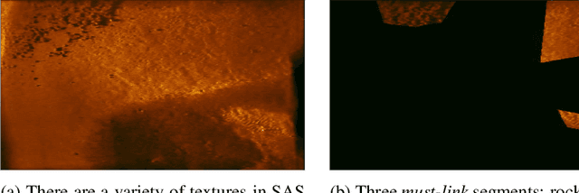
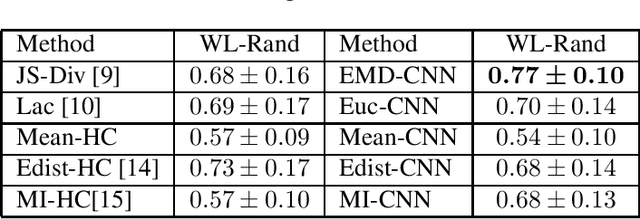
Abstract:Synthetic Aperture Sonar (SAS) surveys produce imagery with large regions of transition between seabed types. Due to these regions, it is difficult to label and segment the imagery and, furthermore, challenging to score the image segmentations appropriately. While there are many approaches to quantify performance in standard crisp segmentation schemes, drawing hard boundaries in remote sensing imagery where gradients and regions of uncertainty exist is inappropriate. These cases warrant weak labels and an associated appropriate scoring approach. In this paper, a labeling approach and associated modified version of the Rand index for weakly-labeled data is introduced to address these issues. Results are evaluated with the new index and compared to traditional segmentation evaluation methods. Experimental results on a SAS data set containing must-link and cannot-link labels show that our Weakly-Labeled Rand index scores segmentations appropriately in reference to qualitative performance and is more suitable than traditional quantitative metrics for scoring weakly-labeled data.
 Add to Chrome
 Add to Firefox
 Add to Edge