Daniel C. Jones
Active Learning with Convolutional Gaussian Neural Processes for Environmental Sensor Placement
Nov 22, 2022Abstract:Deploying environmental measurement stations can be a costly and time-consuming procedure, especially in remote regions that are difficult to access, such as Antarctica. Therefore, it is crucial that sensors are placed as efficiently as possible, maximising the informativeness of their measurements. This can be tackled by fitting a probabilistic model to existing data and identifying placements that would maximally reduce the model's uncertainty. The models most widely used for this purpose are Gaussian processes (GPs). However, designing a GP covariance which captures the complex behaviour of non-stationary spatiotemporal data is a difficult task. Further, the computational cost of GPs makes them challenging to scale to large environmental datasets. In this work, we explore using a convolutional Gaussian neural process (ConvGNP) to address these issues. A ConvGNP is a meta-learning model that uses neural networks to parameterise a GP predictive. Our model is data-driven, flexible, efficient, and permits multiple input predictors of gridded or scattered modalities. Using simulated surface air temperature fields over Antarctica as ground truth, we show that a ConvGNP significantly outperforms a non-stationary GP baseline in terms of predictive performance. We then use the ConvGNP in an Antarctic sensor placement toy experiment, yielding promising results.
Bridging observation, theory and numerical simulation of the ocean using Machine Learning
Apr 26, 2021


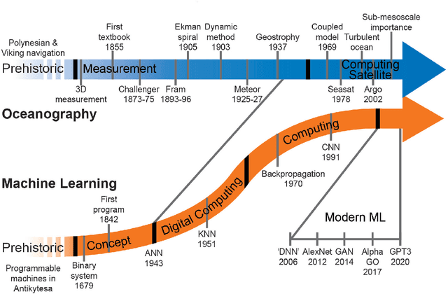
Abstract:Progress within physical oceanography has been concurrent with the increasing sophistication of tools available for its study. The incorporation of machine learning (ML) techniques offers exciting possibilities for advancing the capacity and speed of established methods and also for making substantial and serendipitous discoveries. Beyond vast amounts of complex data ubiquitous in many modern scientific fields, the study of the ocean poses a combination of unique challenges that ML can help address. The observational data available is largely spatially sparse, limited to the surface, and with few time series spanning more than a handful of decades. Important timescales span seconds to millennia, with strong scale interactions and numerical modelling efforts complicated by details such as coastlines. This review covers the current scientific insight offered by applying ML and points to where there is imminent potential. We cover the main three branches of the field: observations, theory, and numerical modelling. Highlighting both challenges and opportunities, we discuss both the historical context and salient ML tools. We focus on the use of ML in situ sampling and satellite observations, and the extent to which ML applications can advance theoretical oceanographic exploration, as well as aid numerical simulations. Applications that are also covered include model error and bias correction and current and potential use within data assimilation. While not without risk, there is great interest in the potential benefits of oceanographic ML applications; this review caters to this interest within the research community.
 Add to Chrome
 Add to Firefox
 Add to Edge