Clément Ubelmann
Training neural mapping schemes for satellite altimetry with simulation data
Sep 19, 2023Abstract:Satellite altimetry combined with data assimilation and optimal interpolation schemes have deeply renewed our ability to monitor sea surface dynamics. Recently, deep learning (DL) schemes have emerged as appealing solutions to address space-time interpolation problems. The scarcity of real altimetry dataset, in terms of space-time coverage of the sea surface, however impedes the training of state-of-the-art neural schemes on real-world case-studies. Here, we leverage both simulations of ocean dynamics and satellite altimeters to train simulation-based neural mapping schemes for the sea surface height and demonstrate their performance for real altimetry datasets. We analyze further how the ocean simulation dataset used during the training phase impacts this performance. This experimental analysis covers both the resolution from eddy-present configurations to eddy-rich ones, forced simulations vs. reanalyses using data assimilation and tide-free vs. tide-resolving simulations. Our benchmarking framework focuses on a Gulf Stream region for a realistic 5-altimeter constellation using NEMO ocean simulations and 4DVarNet mapping schemes. All simulation-based 4DVarNets outperform the operational observation-driven and reanalysis products, namely DUACS and GLORYS. The more realistic the ocean simulation dataset used during the training phase, the better the mapping. The best 4DVarNet mapping was trained from an eddy-rich and tide-free simulation datasets. It improves the resolved longitudinal scale from 151 kilometers for DUACS and 241 kilometers for GLORYS to 98 kilometers and reduces the root mean squared error (RMSE) by 23% and 61%. These results open research avenues for new synergies between ocean modelling and ocean observation using learning-based approaches.
Scale-aware neural calibration for wide swath altimetry observations
Feb 14, 2023Abstract:Sea surface height (SSH) is a key geophysical parameter for monitoring and studying meso-scale surface ocean dynamics. For several decades, the mapping of SSH products at regional and global scales has relied on nadir satellite altimeters, which provide one-dimensional-only along-track satellite observations of the SSH. The Surface Water and Ocean Topography (SWOT) mission deploys a new sensor that acquires for the first time wide-swath two-dimensional observations of the SSH. This provides new means to observe the ocean at previously unresolved spatial scales. A critical challenge for the exploiting of SWOT data is the separation of the SSH from other signals present in the observations. In this paper, we propose a novel learning-based approach for this SWOT calibration problem. It benefits from calibrated nadir altimetry products and a scale-space decomposition adapted to SWOT swath geometry and the structure of the different processes in play. In a supervised setting, our method reaches the state-of-the-art residual error of ~1.4cm while proposing a correction on the entire spectral from 10km to 1000k
A DNN Framework for Learning Lagrangian Drift With Uncertainty
Apr 12, 2022

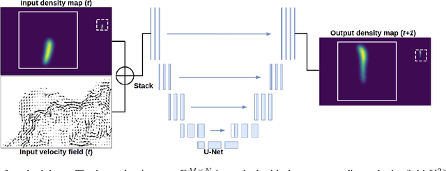

Abstract:Reconstructions of Lagrangian drift, for example for objects lost at sea, are often uncertain due to unresolved physical phenomena within the data. Uncertainty is usually overcome by introducing stochasticity into the drift, but this approach requires specific assumptions for modelling uncertainty. We remove this constraint by presenting a purely data-driven framework for modelling probabilistic drift in flexible environments. We train a CNN to predict the temporal evolution of probability density maps of particle locations from $t$ to $t+1$ given an input velocity field. We generate groundtruth density maps on the basis of ocean circulation model simulations by simulating uncertainty in the initial position of particle trajectories. Several loss functions for regressing the predicted density maps are tested. Through evaluating our model on unseen velocities from a different year, we find its outputs to be in good agreement with numerical simulations, suggesting satisfactory generalisation to different dynamical situations.
Joint calibration and mapping of satellite altimetry data using trainable variational models
Oct 07, 2021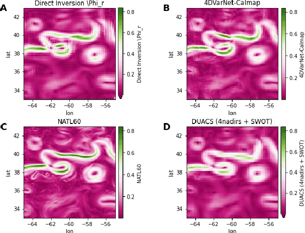
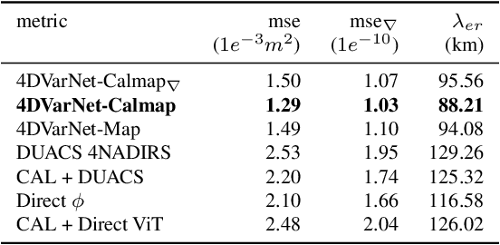
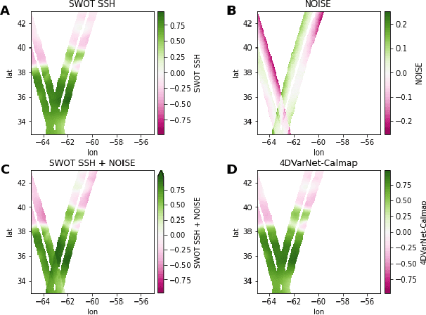
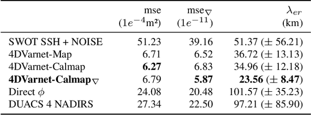
Abstract:Satellite radar altimeters are a key source of observation of ocean surface dynamics. However, current sensor technology and mapping techniques do not yet allow to systematically resolve scales smaller than 100km. With their new sensors, upcoming wide-swath altimeter missions such as SWOT should help resolve finer scales. Current mapping techniques rely on the quality of the input data, which is why the raw data go through multiple preprocessing stages before being used. Those calibration stages are improved and refined over many years and represent a challenge when a new type of sensor start acquiring data. Here we show how a data-driven variational data assimilation framework could be used to jointly learn a calibration operator and an interpolator from non-calibrated data . The proposed framework significantly outperforms the operational state-of-the-art mapping pipeline and truly benefits from wide-swath data to resolve finer scales on the global map as well as in the SWOT sensor geometry.
 Add to Chrome
 Add to Firefox
 Add to Edge