Chengqiao Lin
Modeling Spatial Nonstationarity via Deformable Convolutions for Deep Traffic Flow Prediction
Jan 08, 2021


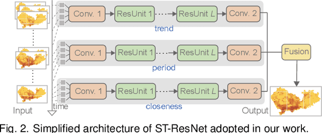
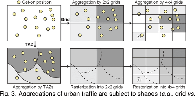
Abstract:Deep neural networks are being increasingly used for short-term traffic flow prediction. Existing convolution-based approaches typically partition an underlying territory into grid-like spatial units, and employ standard convolutions to learn spatial dependence among the units. However, standard convolutions with fixed geometric structures cannot fully model the nonstationary characteristics of local traffic flows. To overcome the deficiency, we introduce deformable convolution that augments the spatial sampling locations with additional offsets, to enhance the modeling capability of spatial nonstationarity. On this basis, we design a deep deformable convolutional residual network, namely DeFlow-Net, that can effectively model global spatial dependence, local spatial nonstationarity, and temporal periodicity of traffic flows. Furthermore, to fit better with convolutions, we suggest to first aggregate traffic flows according to pre-conceived regions of interest, then dispose to sequentially organized raster images for network input. Extensive experiments on real-world traffic flows demonstrate that DeFlow-Net outperforms existing solutions using standard convolutions, and spatial partition by pre-conceived regions further enhances the performance. Finally, we demonstrate the advantage of DeFlow-Net in maintaining spatial autocorrelation, and reveal the impacts of partition shapes and scales on deep traffic flow prediction.
Revisiting the Modifiable Areal Unit Problem in Deep Traffic Prediction with Visual Analytics
Sep 07, 2020


Abstract:Deep learning methods are being increasingly used for urban traffic prediction where spatiotemporal traffic data is aggregated into sequentially organized matrices that are then fed into convolution-based residual neural networks. However, the widely known modifiable areal unit problem within such aggregation processes can lead to perturbations in the network inputs. This issue can significantly destabilize the feature embeddings and the predictions, rendering deep networks much less useful for the experts. This paper approaches this challenge by leveraging unit visualization techniques that enable the investigation of many-to-many relationships between dynamically varied multi-scalar aggregations of urban traffic data and neural network predictions. Through regular exchanges with a domain expert, we design and develop a visual analytics solution that integrates 1) a Bivariate Map equipped with an advanced bivariate colormap to simultaneously depict input traffic and prediction errors across space, 2) a Morans I Scatterplot that provides local indicators of spatial association analysis, and 3) a Multi-scale Attribution View that arranges non-linear dot plots in a tree layout to promote model analysis and comparison across scales. We evaluate our approach through a series of case studies involving a real-world dataset of Shenzhen taxi trips, and through interviews with domain experts. We observe that geographical scale variations have important impact on prediction performances, and interactive visual exploration of dynamically varying inputs and outputs benefit experts in the development of deep traffic prediction models.
 Add to Chrome
 Add to Firefox
 Add to Edge