 Add to Chrome
 Add to Firefox
 Add to Edge
SteLLA: A Structured Grading System Using LLMs with RAG
Jan 15, 2025Large Language Models (LLMs) have shown strong general capabilities in many applications. However, how to make them reliable tools for some specific tasks such as automated short answer grading (ASAG) remains a challenge. We present SteLLA (Structured Grading System Using LLMs with RAG) in which a) Retrieval Augmented Generation (RAG) approach is used to empower LLMs specifically on the ASAG task by extracting structured information from the highly relevant and reliable external knowledge based on the instructor-provided reference answer and rubric, b) an LLM performs a structured and question-answering-based evaluation of student answers to provide analytical grades and feedback. A real-world dataset that contains students' answers in an exam was collected from a college-level Biology course. Experiments show that our proposed system can achieve substantial agreement with the human grader while providing break-down grades and feedback on all the knowledge points examined in the problem. A qualitative and error analysis of the feedback generated by GPT4 shows that GPT4 is good at capturing facts while may be prone to inferring too much implication from the given text in the grading task which provides insights into the usage of LLMs in the ASAG system.
Sub-meter resolution canopy height maps using self-supervised learning and a vision transformer trained on Aerial and GEDI Lidar
Apr 17, 2023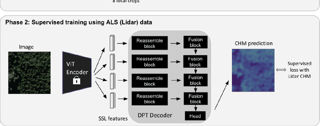
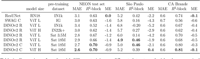
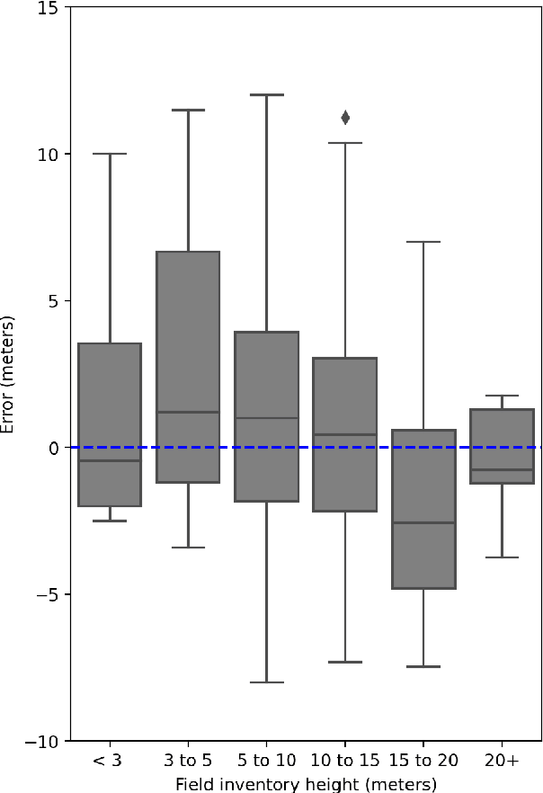

Vegetation structure mapping is critical for understanding the global carbon cycle and monitoring nature-based approaches to climate adaptation and mitigation. Repeat measurements of these data allow for the observation of deforestation or degradation of existing forests, natural forest regeneration, and the implementation of sustainable agricultural practices like agroforestry. Assessments of tree canopy height and crown projected area at a high spatial resolution are also important for monitoring carbon fluxes and assessing tree-based land uses, since forest structures can be highly spatially heterogeneous, especially in agroforestry systems. Very high resolution satellite imagery (less than one meter (1m) ground sample distance) makes it possible to extract information at the tree level while allowing monitoring at a very large scale. This paper presents the first high-resolution canopy height map concurrently produced for multiple sub-national jurisdictions. Specifically, we produce canopy height maps for the states of California and S\~{a}o Paolo, at sub-meter resolution, a significant improvement over the ten meter (10m) resolution of previous Sentinel / GEDI based worldwide maps of canopy height. The maps are generated by applying a vision transformer to features extracted from a self-supervised model in Maxar imagery from 2017 to 2020, and are trained against aerial lidar and GEDI observations. We evaluate the proposed maps with set-aside validation lidar data as well as by comparing with other remotely sensed maps and field-collected data, and find our model produces an average Mean Absolute Error (MAE) within set-aside validation areas of 3.0 meters.