Arianna Traviglia
Hands-Free Heritage: Automated 3D Scanning for Cultural Heritage Digitization
Oct 06, 2025


Abstract:High-fidelity 3D scanning is essential for preserving cultural heritage artefacts, supporting documentation, analysis, and long-term conservation. However, conventional methods typically require specialized expertise and manual intervention to maintain optimal scanning conditions and coverage. We present an automated two-robot scanning system that eliminates the need for handheld or semi-automatic workflows by combining coordinated robotic manipulation with high-resolution 3D scanning. Our system parameterizes the scanning space into distinct regions, enabling coordinated motion planning between a scanner-equipped robot and a tray-handling robot. Optimized trajectory planning and waypoint distribution ensure comprehensive surface coverage, minimize occlusions, and balance reconstruction accuracy with system efficiency. Experimental results show that our approach achieves significantly lower Chamfer Distance and higher F-score compared to baseline methods, offering superior geometric accuracy, improved digitization efficiency, and reduced reliance on expert operators.
Boosting CNN-based Handwriting Recognition Systems with Learnable Relaxation Labeling
Sep 09, 2024


Abstract:The primary challenge for handwriting recognition systems lies in managing long-range contextual dependencies, an issue that traditional models often struggle with. To mitigate it, attention mechanisms have recently been employed to enhance context-aware labelling, thereby achieving state-of-the-art performance. In the field of pattern recognition and image analysis, however, the use of contextual information in labelling problems has a long history and goes back at least to the early 1970's. Among the various approaches developed in those years, Relaxation Labelling (RL) processes have played a prominent role and have been the method of choice in the field for more than a decade. Contrary to recent transformer-based architectures, RL processes offer a principled approach to the use of contextual constraints, having a solid theoretic foundation grounded on variational inequality and game theory, as well as effective algorithms with convergence guarantees. In this paper, we propose a novel approach to handwriting recognition that integrates the strengths of two distinct methodologies. In particular, we propose integrating (trainable) RL processes with various well-established neural architectures and we introduce a sparsification technique that accelerates the convergence of the algorithm and enhances the overall system's performance. Experiments over several benchmark datasets show that RL processes can improve the generalisation ability, even surpassing in some cases transformer-based architectures.
Pansharpening of PRISMA products for archaeological prospection
Apr 08, 2024Abstract:Hyperspectral data recorded from satellite platforms are often ill-suited for geo-archaeological prospection due to low spatial resolution. The established potential of hyperspectral data from airborne sensors in identifying archaeological features has, on the other side, generated increased interest in enhancing hyperspectral data to achieve higher spatial resolution. This improvement is crucial for detecting traces linked to sub-surface geo-archaeological features and can make satellite hyperspectral acquisitions more suitable for archaeological research. This research assesses the usability of pansharpened PRISMA satellite products in geo-archaeological prospections. Three pan-sharpening methods (GSA, MTF-GLP and HySure) are compared quantitatively and qualitatively and tested over the archaeological landscape of Aquileia (Italy). The results suggest that the application of pansharpening techniques makes hyperspectral satellite imagery highly suitable, under certain conditions, to the identification of sub-surface archaeological features of small and large size.
Impact of LiDAR visualisations on semantic segmentation of archaeological objects
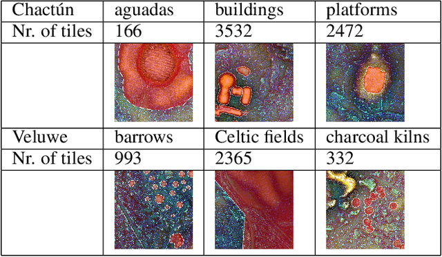
Apr 08, 2024Abstract:Deep learning methods in LiDAR-based archaeological research often leverage visualisation techniques derived from Digital Elevation Models to enhance characteristics of archaeological objects present in the images. This paper investigates the impact of visualisations on deep learning performance through a comprehensive testing framework. The study involves the use of eight semantic segmentation models to evaluate seven diverse visualisations across two study areas, encompassing five archaeological classes. Experimental results reveal that the choice of appropriate visualisations can influence performance by up to 8%. Yet, pinpointing one visualisation that outperforms the others in segmenting all archaeological classes proves challenging. The observed performance variation, reaching up to 25% across different model configurations, underscores the importance of thoughtfully selecting model configurations and LiDAR visualisations for successfully segmenting archaeological objects.
Super-resolution of THz time-domain images based on low-rank representation
Dec 21, 2023


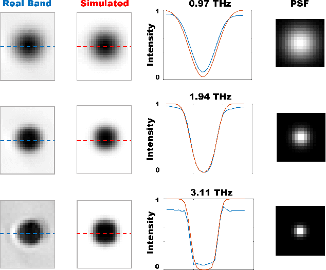
Abstract:Terahertz time-domain spectroscopy (THz-TDS) employs sub-picosecond pulses to probe dielectric properties of materials giving as a result a 3-dimensional hyperspectral data cube. The spatial resolution of THz images is primarily limited by two sources: a non-zero THz beam waist and the acquisition step size. Acquisition with a small step size allows for the visualisation of smaller details in images at the expense of acquisition time, but the frequency-dependent point-spread function remains the biggest bottleneck for THz imaging. This work presents a super-resolution approach to restore THz time-domain images acquired with medium-to-big step sizes. The results show the optimized and robust performance for different frequency bands (from 0.5 to 3.5 THz) obtaining higher resolution and additionally removing effects of blur at lower frequencies and noise at higher frequencies.
* This work was presented at the Sixth International Workshop on Mobile Terahertz Systems (IWMTS)
Implicit neural representation for change detection
Jul 28, 2023Abstract:Detecting changes that occurred in a pair of 3D airborne LiDAR point clouds, acquired at two different times over the same geographical area, is a challenging task because of unmatching spatial supports and acquisition system noise. Most recent attempts to detect changes on point clouds are based on supervised methods, which require large labelled data unavailable in real-world applications. To address these issues, we propose an unsupervised approach that comprises two components: Neural Field (NF) for continuous shape reconstruction and a Gaussian Mixture Model for categorising changes. NF offer a grid-agnostic representation to encode bi-temporal point clouds with unmatched spatial support that can be regularised to increase high-frequency details and reduce noise. The reconstructions at each timestamp are compared at arbitrary spatial scales, leading to a significant increase in detection capabilities. We apply our method to a benchmark dataset of simulated LiDAR point clouds for urban sprawling. The dataset offers different challenging scenarios with different resolutions, input modalities and noise levels, allowing a multi-scenario comparison of our method with the current state-of-the-art. We boast the previous methods on this dataset by a 10% margin in intersection over union metric. In addition, we apply our methods to a real-world scenario to identify illegal excavation (looting) of archaeological sites and confirm that they match findings from field experts.
Tranfer Learning of Semantic Segmentation Methods for Identifying Buried Archaeological Structures on LiDAR Data
Jul 20, 2023

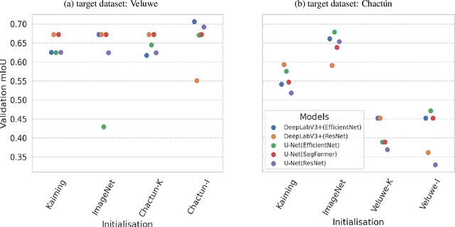
Abstract:When applying deep learning to remote sensing data in archaeological research, a notable obstacle is the limited availability of suitable datasets for training models. The application of transfer learning is frequently employed to mitigate this drawback. However, there is still a need to explore its effectiveness when applied across different archaeological datasets. This paper compares the performance of various transfer learning configurations using two semantic segmentation deep neural networks on two LiDAR datasets. The experimental results indicate that transfer learning-based approaches in archaeology can lead to performance improvements, although a systematic enhancement has not yet been observed. We provide specific insights about the validity of such techniques that can serve as a baseline for future works.
Relaxation Labeling Meets GANs: Solving Jigsaw Puzzles with Missing Borders
Mar 28, 2022


Abstract:This paper proposes JiGAN, a GAN-based method for solving Jigsaw puzzles with eroded or missing borders. Missing borders is a common real-world situation, for example, when dealing with the reconstruction of broken artifacts or ruined frescoes. In this particular condition, the puzzle's pieces do not align perfectly due to the borders' gaps; in this situation, the patches' direct match is unfeasible due to the lack of color and line continuations. JiGAN, is a two-steps procedure that tackles this issue: first, we repair the eroded borders with a GAN-based image extension model and measure the alignment affinity between pieces; then, we solve the puzzle with the relaxation labeling algorithm to enforce consistency in pieces positioning, hence, reconstructing the puzzle. We test the method on a large dataset of small puzzles and on three commonly used benchmark datasets to demonstrate the feasibility of the proposed approach.
Beam-Shape Effects and Noise Removal from THz Time-Domain Images in Reflection Geometry in the 0.25-6 THz Range
Mar 01, 2022


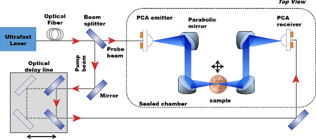
Abstract:The increasing need of restoring high-resolution Hyper-Spectral (HS) images is determining a growing reliance on Computer Vision-based processing to enhance the clarity of the image content. HS images can, in fact, suffer from degradation effects or artefacts caused by instrument limitations. This paper focuses on a procedure aimed at reducing the degradation effects, frequency-dependent blur and noise, in Terahertz Time-Domain Spectroscopy (THz-TDS) images in reflection geometry. It describes the application of a joint deblurring and denoising approach that had been previously proved to be effective for the restoration of THz-TDS images in transmission geometry, but that had never been tested in reflection modality. This mode is often the only one that can be effectively used in most cases, for example when analyzing objects that are either opaque in the THz range, or that cannot be displaced from their location (e.g., museums), such as those of cultural interest. Compared to transmission mode, reflection geometry introduces, however, further distortion to THz data, neglected in existing literature. In this work, we successfully implement image deblurring and denoising of both uniform-shape samples (a contemporary 1 Euro cent coin and an inlaid pendant) and samples with the uneven reliefs and corrosion products on the surface which make the analysis of the object particularly complex (an ancient Roman silver coin). The study demonstrates the ability of image processing to restore data in the 0.25 - 6 THz range, spanning over more than four octaves, and providing the foundation for future analytical approaches of cultural heritage using the far-infrared spectrum still not sufficiently investigated in literature.
 Add to Chrome
 Add to Firefox
 Add to Edge