Amirabbas Davari
Bayesian Convolutional Neural Networks for Limited Data Hyperspectral Remote Sensing Image Classification
May 30, 2022


Abstract:Employing deep neural networks for Hyperspectral remote sensing (HSRS) image classification is a challenging task. HSRS images have high dimensionality and a large number of channels with substantial redundancy between channels. In addition, the training data for classifying HSRS images is limited and the amount of available training data is much smaller compared to other classification tasks. These factors complicate the training process of deep neural networks with many parameters and cause them to not perform well even compared to conventional models. Moreover, convolutional neural networks produce over-confident predictions, which is highly undesirable considering the aforementioned problem. In this work, we use for HSRS image classification a special class of deep neural networks, namely a Bayesian neural network (BNN). To the extent of our knowledge, this is the first time that BNNs are used in HSRS image classification. BNNs inherently provide a measure for uncertainty. We perform extensive experiments on the Pavia Centre, Salinas, and Botswana datasets. We show that a BNN outperforms a standard convolutional neural network (CNN) and an off-the-shelf Random Forest (RF). Further experiments underline that the BNN is more stable and robust to model pruning, and that the uncertainty is higher for samples with higher expected prediction error.
On Mathews Correlation Coefficient and Improved Distance Map Loss for Automatic Glacier Calving Front Segmentation in SAR Imagery
Mar 09, 2021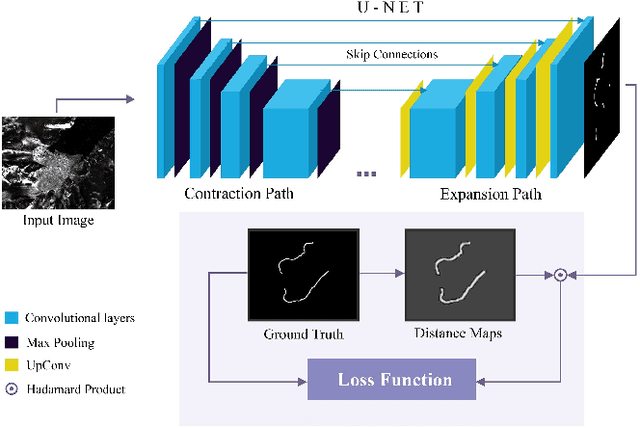
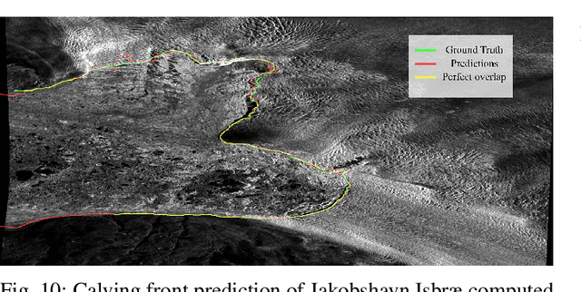
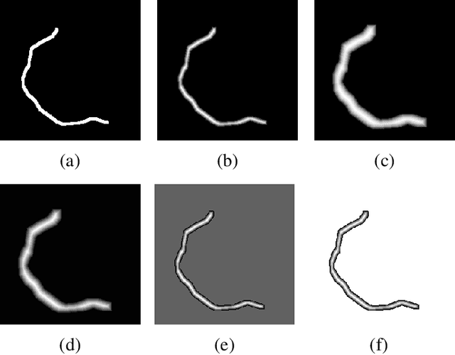
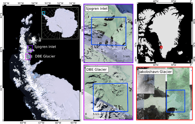
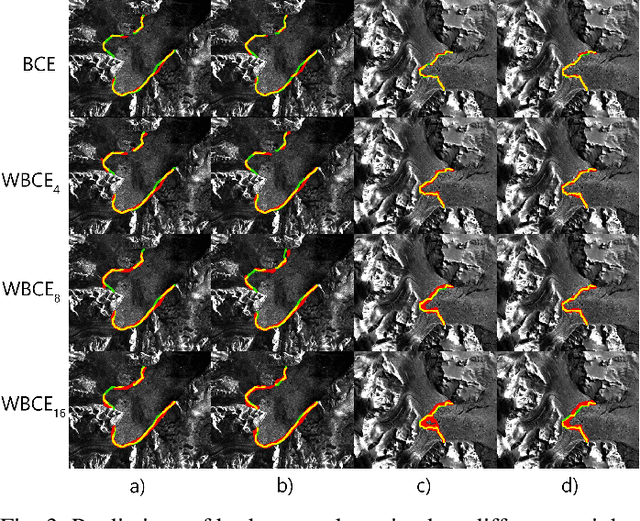
Abstract:The vast majority of the outlet glaciers and ice streams of the polar ice sheets end in the ocean. Ice mass loss via calving of the glaciers into the ocean has increased over the last few decades. Information on the temporal variability of the calving front position provides fundamental information on the state of the glacier and ice stream, which can be exploited as calibration and validation data to enhance ice dynamics modeling. To identify the calving front position automatically, deep neural network-based semantic segmentation pipelines can be used to delineate the acquired SAR imagery. However, the extreme class imbalance is highly challenging for the accurate calving front segmentation in these images. Therefore, we propose the use of the Mathews correlation coefficient (MCC) as an early stopping criterion because of its symmetrical properties and its invariance towards class imbalance. Moreover, we propose an improvement to the distance map-based binary cross-entropy (BCE) loss function. The distance map adds context to the loss function about the important regions for segmentation and helps accounting for the imbalanced data. Using Mathews correlation coefficient as early stopping demonstrates an average 15% dice coefficient improvement compared to the commonly used BCE. The modified distance map loss further improves the segmentation performance by another 2%. These results are encouraging as they support the effectiveness of the proposed methods for segmentation problems suffering from extreme class imbalances.
Pixel-wise Distance Regression for Glacier Calving Front Detection and Segmentation
Mar 09, 2021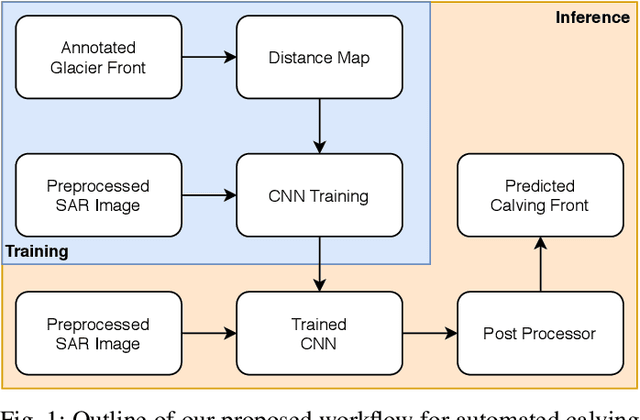
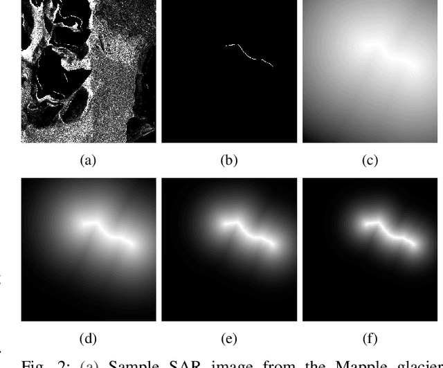
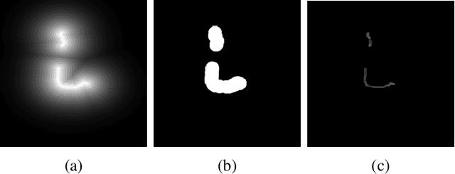
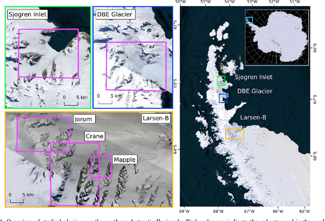
Abstract:Glacier calving front position (CFP) is an important glaciological variable. Traditionally, delineating the CFPs has been carried out manually, which was subjective, tedious and expensive. Automating this process is crucial for continuously monitoring the evolution and status of glaciers. Recently, deep learning approaches have been investigated for this application. However, the current methods get challenged by a severe class-imbalance problem. In this work, we propose to mitigate the class-imbalance between the calving front class and the non-calving front class by reformulating the segmentation problem into a pixel-wise regression task. A Convolutional Neural Network gets optimized to predict the distance values to the glacier front for each pixel in the image. The resulting distance map localizes the CFP and is further post-processed to extract the calving front line. We propose three post-processing methods, one method based on statistical thresholding, a second method based on conditional random fields (CRF), and finally the use of a second U-Net. The experimental results confirm that our approach significantly outperforms the state-of-the-art methods and produces accurate delineation. The Second U-Net obtains the best performance results, resulting in an average improvement of about 21% dice coefficient enhancement.
Synthetic Glacier SAR Image Generation from Arbitrary Masks Using Pix2Pix Algorithm
Jan 14, 2021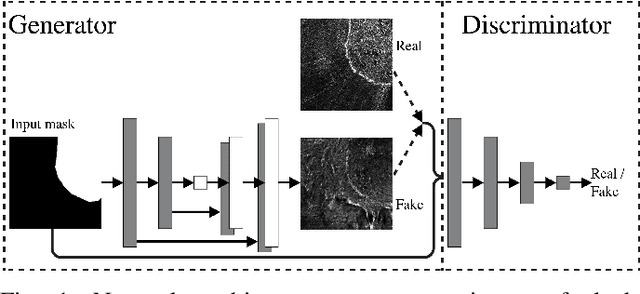
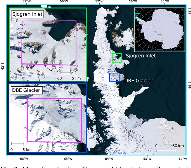
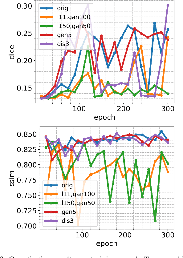
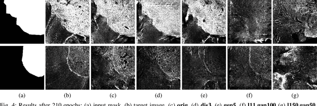
Abstract:Supervised machine learning requires a large amount of labeled data to achieve proper test results. However, generating accurately labeled segmentation maps on remote sensing imagery, including images from synthetic aperture radar (SAR), is tedious and highly subjective. In this work, we propose to alleviate the issue of limited training data by generating synthetic SAR images with the pix2pix algorithm. This algorithm uses conditional Generative Adversarial Networks (cGANs) to generate an artificial image while preserving the structure of the input. In our case, the input is a segmentation mask, from which a corresponding synthetic SAR image is generated. We present different models, perform a comparative study and demonstrate that this approach synthesizes convincing glaciers in SAR images with promising qualitative and quantitative results.
Bayesian U-Net for Segmenting Glaciers in SAR Imagery
Jan 08, 2021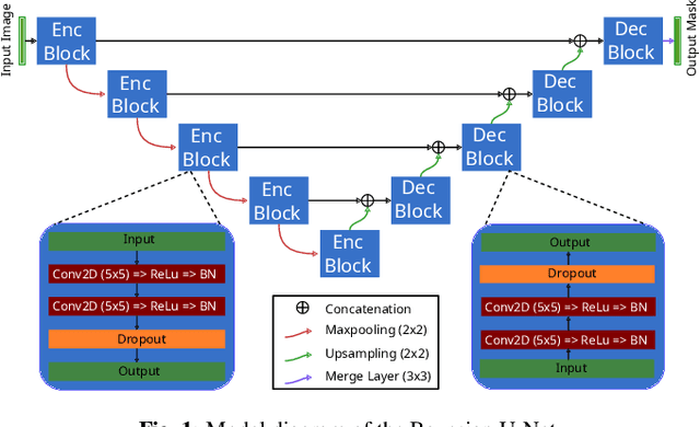
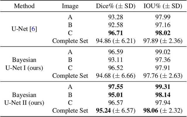
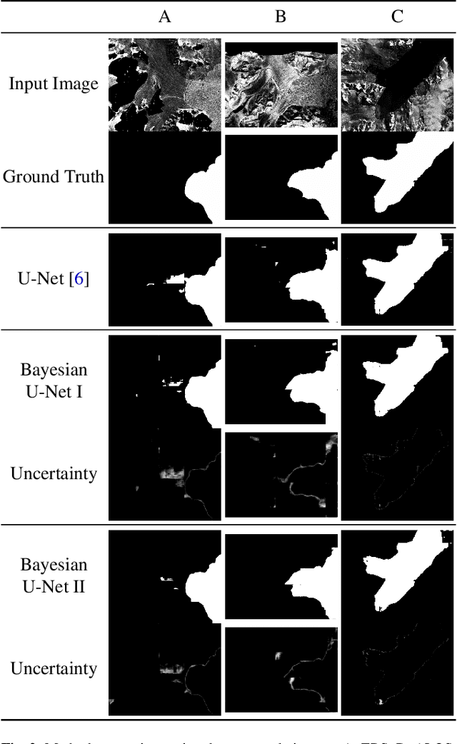
Abstract:Fluctuations of the glacier calving front have an important influence over the ice flow of whole glacier systems. It is therefore important to precisely monitor the position of the calving front. However, the manual delineation of SAR images is a difficult, laborious and subjective task. Convolutional neural networks have previously shown promising results in automating the glacier segmentation in SAR images, making them desirable for further exploration of their possibilities. In this work, we propose to compute uncertainty and use it in an Uncertainty Optimization regime as a novel two-stage process. By using dropout as a random sampling layer in a U-Net architecture, we create a probabilistic Bayesian Neural Network. With several forward passes, we create a sampling distribution, which can estimate the model uncertainty for each pixel in the segmentation mask. The additional uncertainty map information can serve as a guideline for the experts in the manual annotation of the data. Furthermore, feeding the uncertainty map to the network leads to 95.24% Dice similarity, which is an overall improvement in the segmentation performance compared to the state-of-the-art deterministic U-Net-based glacier segmentation pipelines.
Glacier Calving Front Segmentation Using Attention U-Net
Jan 08, 2021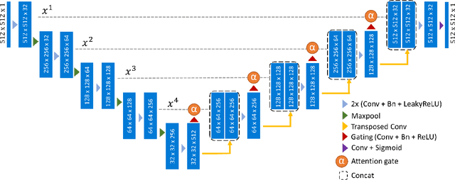

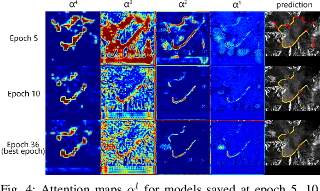
Abstract:An essential climate variable to determine the tidewater glacier status is the location of the calving front position and the separation of seasonal variability from long-term trends. Previous studies have proposed deep learning-based methods to semi-automatically delineate the calving fronts of tidewater glaciers. They used U-Net to segment the ice and non-ice regions and extracted the calving fronts in a post-processing step. In this work, we show a method to segment the glacier calving fronts from SAR images in an end-to-end fashion using Attention U-Net. The main objective is to investigate the attention mechanism in this application. Adding attention modules to the state-of-the-art U-Net network lets us analyze the learning process by extracting its attention maps. We use these maps as a tool to search for proper hyperparameters and loss functions in order to generate higher qualitative results. Our proposed attention U-Net performs comparably to the standard U-Net while providing additional insight into those regions on which the network learned to focus more. In the best case, the attention U-Net achieves a 1.5% better Dice score compared to the canonical U-Net with a glacier front line prediction certainty of up to 237.12 meters.
Semi-Automatic Algorithm for Breast MRI Lesion Segmentation Using Marker-Controlled Watershed Transformation
Dec 14, 2017


Abstract:Magnetic resonance imaging (MRI) is an effective imaging modality for identifying and localizing breast lesions in women. Accurate and precise lesion segmentation using a computer-aided-diagnosis (CAD) system, is a crucial step in evaluating tumor volume and in the quantification of tumor characteristics. However, this is a challenging task, since breast lesions have sophisticated shape, topological structure, and high variance in their intensity distribution across patients. In this paper, we propose a novel marker-controlled watershed transformation-based approach, which uses the brightest pixels in a region of interest (determined by experts) as markers to overcome this challenge, and accurately segment lesions in breast MRI. The proposed approach was evaluated on 106 lesions, which includes 64 malignant and 42 benign cases. Segmentation results were quantified by comparison with ground truth labels, using the Dice similarity coefficient (DSC) and Jaccard index (JI) metrics. The proposed method achieved an average Dice coefficient of 0.7808$\pm$0.1729 and Jaccard index of 0.6704$\pm$0.2167. These results illustrate that the proposed method shows promise for future work related to the segmentation and classification of benign and malignant breast lesions.
 Add to Chrome
 Add to Firefox
 Add to Edge