 Add to Chrome
 Add to Firefox
 Add to Edge
AerOSeg: Harnessing SAM for Open-Vocabulary Segmentation in Remote Sensing Images
Apr 12, 2025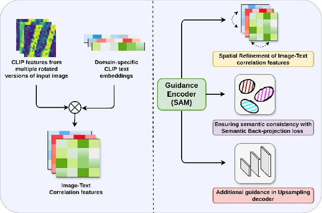

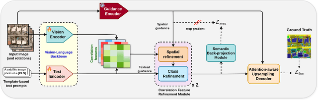

Image segmentation beyond predefined categories is a key challenge in remote sensing, where novel and unseen classes often emerge during inference. Open-vocabulary image Segmentation addresses these generalization issues in traditional supervised segmentation models while reducing reliance on extensive per-pixel annotations, which are both expensive and labor-intensive to obtain. Most Open-Vocabulary Segmentation (OVS) methods are designed for natural images but struggle with remote sensing data due to scale variations, orientation changes, and complex scene compositions. This necessitates the development of OVS approaches specifically tailored for remote sensing. In this context, we propose AerOSeg, a novel OVS approach for remote sensing data. First, we compute robust image-text correlation features using multiple rotated versions of the input image and domain-specific prompts. These features are then refined through spatial and class refinement blocks. Inspired by the success of the Segment Anything Model (SAM) in diverse domains, we leverage SAM features to guide the spatial refinement of correlation features. Additionally, we introduce a semantic back-projection module and loss to ensure the seamless propagation of SAM's semantic information throughout the segmentation pipeline. Finally, we enhance the refined correlation features using a multi-scale attention-aware decoder to produce the final segmentation map. We validate our SAM-guided Open-Vocabulary Remote Sensing Segmentation model on three benchmark remote sensing datasets: iSAID, DLRSD, and OpenEarthMap. Our model outperforms state-of-the-art open-vocabulary segmentation methods, achieving an average improvement of 2.54 h-mIoU.
MIMRS: A Survey on Masked Image Modeling in Remote Sensing
Apr 07, 2025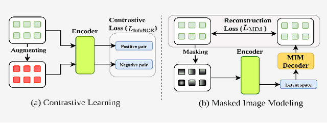


Masked Image Modeling (MIM) is a self-supervised learning technique that involves masking portions of an image, such as pixels, patches, or latent representations, and training models to predict the missing information using the visible context. This approach has emerged as a cornerstone in self-supervised learning, unlocking new possibilities in visual understanding by leveraging unannotated data for pre-training. In remote sensing, MIM addresses challenges such as incomplete data caused by cloud cover, occlusions, and sensor limitations, enabling applications like cloud removal, multi-modal data fusion, and super-resolution. By synthesizing and critically analyzing recent advancements, this survey (MIMRS) is a pioneering effort to chart the landscape of mask image modeling in remote sensing. We highlight state-of-the-art methodologies, applications, and future research directions, providing a foundational review to guide innovation in this rapidly evolving field.