Adam Watts
Sub-Meter Remote Sensing of Soil Moisture Using Portable L-band Microwave Radiometer
Sep 25, 2024Abstract:Spaceborne microwave passive soil moisture products are known for their accuracy but are often limited by coarse spatial resolutions. This limits their ability to capture finer soil moisture gradients and hinders their applications. The Portable L band radiometer (PoLRa) offers soil moisture measurements from submeter to tens of meters depending on the altitude of measurement. Given that the assessments of soil moisture derived from this sensor are notably lacking, this study aims to evaluate the performance of submeter soil moisture retrieved from PoLRa mounted on poles at four different locations in central Illinois, USA. The evaluation focuses on the consistency of PoLRa measured brightness temperatures from different directions relative to the same area, and the accuracy of PoLRa derived soil moisture. As PoLRa shares many aspects of the L band radiometer onboard the NASA Soil Moisture Active Passive (SMAP) mission, two SMAP operational algorithms and the conventional dual channel algorithm were applied to calculate soil moisture from the measured brightness temperatures. The vertically polarized brightness temperatures from the PoLRa are typically more stable than their horizontally polarized counterparts. In each test period, the standard deviations of observed dual polarization brightness temperatures are generally less than 5 K. By comparing PoLRa based soil moisture retrievals against the moisture values obtained by handheld time domain reflectometry, the unbiased root mean square error and the Pearson correlation coefficient are mostly below 0.04 and above 0.75, confirming the high accuracy of PoLRa derived soil moisture retrievals and the feasibility of utilizing SMAP algorithms for PoLRa data. These findings highlight the significant potential of ground or drone based PoLRa measurements as a standalone reference for future spaceborne L band sensors.
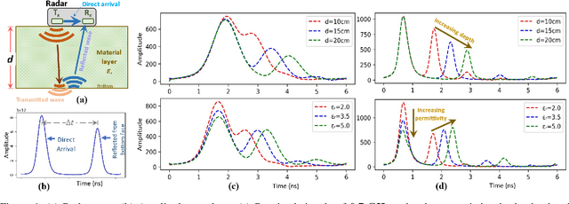
Joint Soil and Above-Ground Biomass Characterization Using Radars
Apr 23, 2024


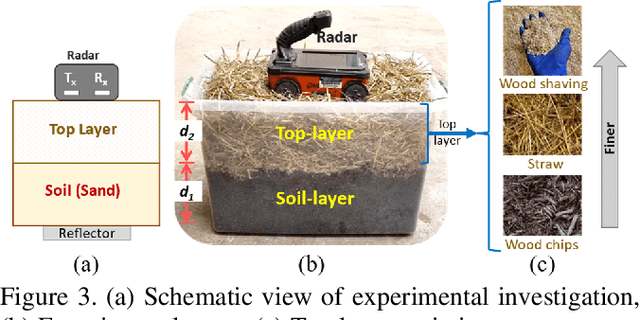
Abstract:Soil moisture sensing through biomass or vegetation canopy has challenged researchers, even those who use SAR sensors with penetration capabilities. This is mainly due to the imposed extra time and phase offsets on Radio Frequency (RF) signals as they travel through the canopy. These offsets depend on the vegetation canopy moisture and height, both of which are typically unknown in agricultural and forest fields. In this paper, we leverage the mobility of an unmanned aerial system (UAS) to collect spatially-diverse radar measurements, enabling the joint estimation of soil moisture, above-ground biomass moisture, and biomass height, all without assuming any calibration steps. We leverage the changes in time-of-flight (ToF) and angle-of-arrival (AoA) measurements of reflected radar signals as the UAS flies above a reflector buried under the soil. We demonstrate the effectiveness of our algorithm by simulating its performance under realistic measurement noises as well as conducting lab experiments with different types of above-ground biomass. Our simulation results conclude that our algorithm is capable of estimating volumetric soil moisture to less than 1% median absolute error (MAE), vegetation height to 11.1cm MAE, and vegetation relative permittivity to 0.32 MAE. Our experimental results demonstrate the effectiveness of the proposed method in practical scenarios for varying biomass moistures and heights.
Dual-Frequency Radar Wave-Inversion for Sub-Surface Material Characterization
Mar 28, 2024


Abstract:Moisture estimation of sub-surface soil and the overlaying biomass layer is pivotal in precision agriculture and wildfire risk assessment. However, the characterization of layered material is nontrivial due to the radar penetration-resolution tradeoff. Here, a waveform inversion-based method was proposed for predicting the dielectric permittivity (as a moisture proxy) of the bottom soil layer and the top biomass layer from radar signals. Specifically, the use of a combination of a higher and a lower frequency radar compared to a single frequency in predicting the permittivity of both the soil and the overlaying layer was investigated in this study. The results show that each layer was best characterized via one of the frequencies. However, for the simultaneous prediction of both layers permittivity, the most consistent results were achieved by inversion of data from a combination of both frequencies, showing better correlation with in situ permittivity and reduced prediction errors.
FUELVISION: A Multimodal Data Fusion and Multimodel Ensemble Algorithm for Wildfire Fuels Mapping
Mar 19, 2024Abstract:Accurate assessment of fuel conditions is a prerequisite for fire ignition and behavior prediction, and risk management. The method proposed herein leverages diverse data sources including Landsat-8 optical imagery, Sentinel-1 (C-band) Synthetic Aperture Radar (SAR) imagery, PALSAR (L-band) SAR imagery, and terrain features to capture comprehensive information about fuel types and distributions. An ensemble model was trained to predict landscape-scale fuels such as the 'Scott and Burgan 40' using the as-received Forest Inventory and Analysis (FIA) field survey plot data obtained from the USDA Forest Service. However, this basic approach yielded relatively poor results due to the inadequate amount of training data. Pseudo-labeled and fully synthetic datasets were developed using generative AI approaches to address the limitations of ground truth data availability. These synthetic datasets were used for augmenting the FIA data from California to enhance the robustness and coverage of model training. The use of an ensemble of methods including deep learning neural networks, decision trees, and gradient boosting offered a fuel mapping accuracy of nearly 80\%. Through extensive experimentation and evaluation, the effectiveness of the proposed approach was validated for regions of the 2021 Dixie and Caldor fires. Comparative analyses against high-resolution data from the National Agriculture Imagery Program (NAIP) and timber harvest maps affirmed the robustness and reliability of the proposed approach, which is capable of near-real-time fuel mapping.
A comprehensive survey of research towards AI-enabled unmanned aerial systems in pre-, active-, and post-wildfire management
Jan 04, 2024Abstract:Wildfires have emerged as one of the most destructive natural disasters worldwide, causing catastrophic losses in both human lives and forest wildlife. Recently, the use of Artificial Intelligence (AI) in wildfires, propelled by the integration of Unmanned Aerial Vehicles (UAVs) and deep learning models, has created an unprecedented momentum to implement and develop more effective wildfire management. Although some of the existing survey papers have explored various learning-based approaches, a comprehensive review emphasizing the application of AI-enabled UAV systems and their subsequent impact on multi-stage wildfire management is notably lacking. This survey aims to bridge these gaps by offering a systematic review of the recent state-of-the-art technologies, highlighting the advancements of UAV systems and AI models from pre-fire, through the active-fire stage, to post-fire management. To this aim, we provide an extensive analysis of the existing remote sensing systems with a particular focus on the UAV advancements, device specifications, and sensor technologies relevant to wildfire management. We also examine the pre-fire and post-fire management approaches, including fuel monitoring, prevention strategies, as well as evacuation planning, damage assessment, and operation strategies. Additionally, we review and summarize a wide range of computer vision techniques in active-fire management, with an emphasis on Machine Learning (ML), Reinforcement Learning (RL), and Deep Learning (DL) algorithms for wildfire classification, segmentation, detection, and monitoring tasks. Ultimately, we underscore the substantial advancement in wildfire modeling through the integration of cutting-edge AI techniques and UAV-based data, providing novel insights and enhanced predictive capabilities to understand dynamic wildfire behavior.
Bayesian inversion of GPR waveforms for uncertainty-aware sub-surface material characterization
Dec 13, 2023Abstract:Accurate estimation of sub-surface properties like moisture content and depth of layers is crucial for applications spanning sub-surface condition monitoring, precision agriculture, and effective wildfire risk assessment. Soil in nature is often covered by overlaying surface material, making its characterization using conventional methods challenging. In addition, the estimation of the properties of the overlaying layer is crucial for applications like wildfire assessment. This study thus proposes a Bayesian model-updating-based approach for ground penetrating radar (GPR) waveform inversion to predict sub-surface properties like the moisture contents and depths of the soil layer and overlaying material accumulated above the soil. The dielectric permittivity of material layers were predicted with the proposed method, along with other parameters, including depth and electrical conductivity of layers. The proposed Bayesian model updating approach yields probabilistic estimates of these parameters that can provide information about the confidence and uncertainty related to the estimates. The methodology was evaluated for a diverse range of experimental data collected through laboratory and field investigations. Laboratory investigations included variations in soil moisture values and depth of the top layer (or overlaying material), and the field investigation included measurement of field soil moisture for sixteen days. The results demonstrated predictions consistent with time-domain reflectometry (TDR) measurements and conventional gravimetric tests. The top layer depth could also be predicted with reasonable accuracy. The proposed method provides a promising approach for uncertainty-aware sub-surface parameter estimation that can enable decision-making for risk assessment across a wide range of applications.
 Add to Chrome
 Add to Firefox
 Add to Edge