 Add to Chrome
 Add to Firefox
 Add to Edge
M2UD: A Multi-model, Multi-scenario, Uneven-terrain Dataset for Ground Robot with Localization and Mapping Evaluation
Paper and Code
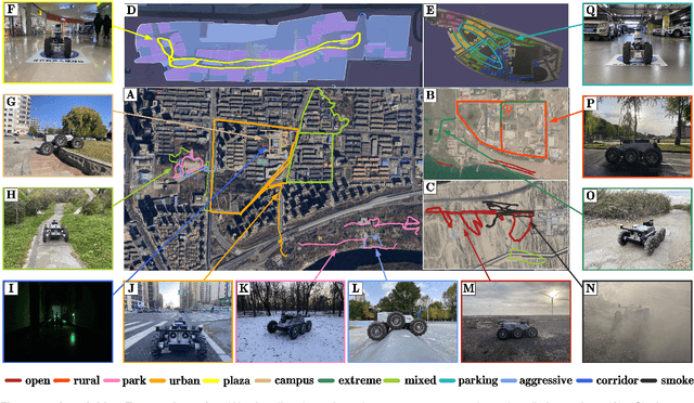
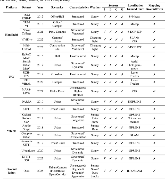
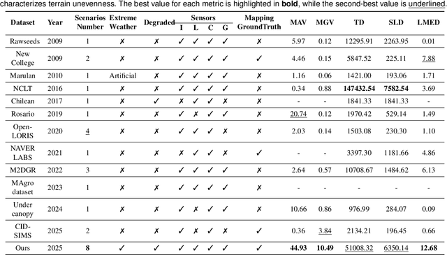
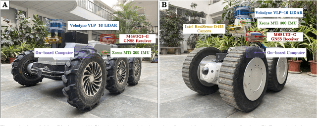
Ground robots play a crucial role in inspection, exploration, rescue, and other applications. In recent years, advancements in LiDAR technology have made sensors more accurate, lightweight, and cost-effective. Therefore, researchers increasingly integrate sensors, for SLAM studies, providing robust technical support for ground robots and expanding their application domains. Public datasets are essential for advancing SLAM technology. However, existing datasets for ground robots are typically restricted to flat-terrain motion with 3 DOF and cover only a limited range of scenarios. Although handheld devices and UAV exhibit richer and more aggressive movements, their datasets are predominantly confined to small-scale environments due to endurance limitations. To fill these gap, we introduce M2UD, a multi-modal, multi-scenario, uneven-terrain SLAM dataset for ground robots. This dataset contains a diverse range of highly challenging environments, including cities, open fields, long corridors, and mixed scenarios. Additionally, it presents extreme weather conditions. The aggressive motion and degradation characteristics of this dataset not only pose challenges for testing and evaluating existing SLAM methods but also advance the development of more advanced SLAM algorithms. To benchmark SLAM algorithms, M2UD provides smoothed ground truth localization data obtained via RTK and introduces a novel localization evaluation metric that considers both accuracy and efficiency. Additionally, we utilize a high-precision laser scanner to acquire ground truth maps of two representative scenes, facilitating the development and evaluation of mapping algorithms. We select 12 localization sequences and 2 mapping sequences to evaluate several classical SLAM algorithms, verifying usability of the dataset. To enhance usability, the dataset is accompanied by a suite of development kits.