Zhifei Duan
VSRQ: Quantitative Assessment Method for Safety Risk of Vehicle Intelligent Connected System
May 03, 2023


Abstract:The field of intelligent connected in modern vehicles continues to expand, and the functions of vehicles become more and more complex with the development of the times. This has also led to an increasing number of vehicle vulnerabilities and many safety issues. Therefore, it is particularly important to identify high-risk vehicle intelligent connected systems, because it can inform security personnel which systems are most vulnerable to attacks, allowing them to conduct more thorough inspections and tests. In this paper, we develop a new model for vehicle risk assessment by combining I-FAHP with FCA clustering: VSRQ model. We extract important indicators related to vehicle safety, use fuzzy cluster analys (FCA) combined with fuzzy analytic hierarchy process (FAHP) to mine the vulnerable components of the vehicle intelligent connected system, and conduct priority testing on vulnerable components to reduce risks and ensure vehicle safety. We evaluate the model on OpenPilot and experimentally demonstrate the effectiveness of the VSRQ model in identifying the safety of vehicle intelligent connected systems. The experiment fully complies with ISO 26262 and ISO/SAE 21434 standards, and our model has a higher accuracy rate than other models. These results provide a promising new research direction for predicting the security risks of vehicle intelligent connected systems and provide typical application tasks for VSRQ. The experimental results show that the accuracy rate is 94.36%, and the recall rate is 73.43%, which is at least 14.63% higher than all other known indicators.
LMBAO: A Landmark Map for Bundle Adjustment Odometry in LiDAR SLAM
Sep 19, 2022


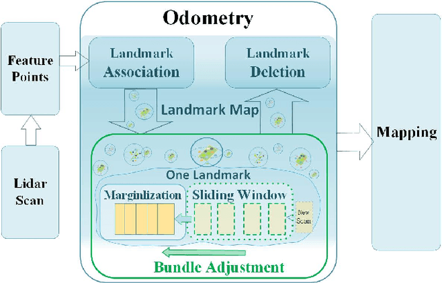
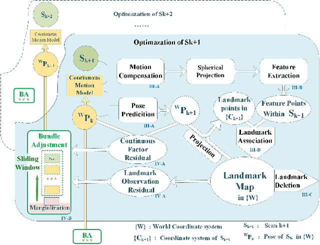
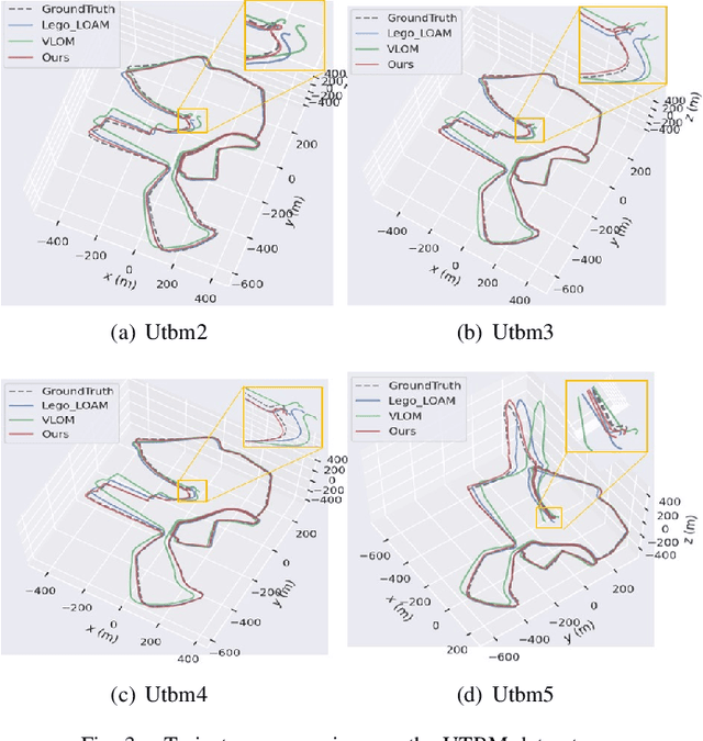
Abstract:LiDAR odometry is one of the essential parts of LiDAR simultaneous localization and mapping (SLAM). However, existing LiDAR odometry tends to match a new scan simply iteratively with previous fixed-pose scans, gradually accumulating errors. Furthermore, as an effective joint optimization mechanism, bundle adjustment (BA) cannot be directly introduced into real-time odometry due to the intensive computation of large-scale global landmarks. Therefore, this letter designs a new strategy named a landmark map for bundle adjustment odometry (LMBAO) in LiDAR SLAM to solve these problems. First, BA-based odometry is further developed with an active landmark maintenance strategy for a more accurate local registration and avoiding cumulative errors. Specifically, this paper keeps entire stable landmarks on the map instead of just their feature points in the sliding window and deletes the landmarks according to their active grade. Next, the sliding window length is reduced, and marginalization is performed to retain the scans outside the window but corresponding to active landmarks on the map, greatly simplifying the computation and improving the real-time properties. In addition, experiments on three challenging datasets show that our algorithm achieves real-time performance in outdoor driving and outperforms state-of-the-art LiDAR SLAM algorithms, including Lego-LOAM and VLOM.
 Add to Chrome
 Add to Firefox
 Add to Edge