 Add to Chrome
 Add to Firefox
 Add to Edge
Towards Athlete Fatigue Assessment from Association Football Videos
Apr 07, 2026Fatigue monitoring is central in association football due to its links with injury risk and tactical performance. However, objective fatigue-related indicators are commonly derived from subjective self-reported metrics, biomarkers derived from laboratory tests, or, more recently, intrusive sensors such as heart monitors or GPS tracking data. This paper studies whether monocular broadcast videos can provide spatio-temporal signals of sufficient quality to support fatigue-oriented analysis. Building on state-of-the-art Game State Reconstruction methods, we extract player trajectories in pitch coordinates and propose a novel kinematics processing algorithm to obtain temporally consistent speed and acceleration estimates from reconstructed tracks. We then construct acceleration--speed (A-S) profiles from these signals and analyze their behavior as fatigue-related performance indicators. We evaluate the full pipeline on the public SoccerNet-GSR benchmark, considering both 30-second clips and a complete 45-minute half to examine short-term reliability and longer-term temporal consistency. Our results indicate that monocular GSR can recover kinematic patterns that are compatible with A-S profiling while also revealing sensitivity to trajectory noise, calibration errors, and temporal discontinuities inherent to broadcast footage. These findings support monocular broadcast video as a low-cost basis for fatigue analysis and delineate the methodological challenges for future research.
Unlocking Few-Shot Capabilities in LVLMs via Prompt Conditioning and Head Selection
Mar 25, 2026Current Large Vision Language Models (LVLMs) excel at many zero-shot tasks like image captioning, visual question answering and OCR. However, these same models suffer from poor performance at image classification tasks, underperforming against CLIP-based methods. Notably, this gap is surprising because many LVLMs use CLIP-pretrained vision encoders. Yet LVLMs are not inherently limited by CLIP's architecture with independent vision and text encoders. In CLIP, this separation biases classification toward class-name matching rather than joint visual-text reasoning. In this paper we show that, despite their poor raw performance, LVLMs can improve visual feature class separability at inference using prompt conditioning, and LVLMs' internal representations, especially attention heads, can outperform the model itself at zero-shot and few-shot classification. We introduce Head Ensemble Classifiers (HEC) to bridge the performance gap between CLIP-based and LVLM-based classification methods. Inspired by Gaussian Discriminant Analysis, HEC ranks the most discriminative vision and text heads and combines them into a training-free classifier. We show that HEC achieves state-of-the-art performance in few-shot and zero-shot classification across 12 datasets.
Remote Sensing Change Detection via Weak Temporal Supervision
Jan 05, 2026Semantic change detection in remote sensing aims to identify land cover changes between bi-temporal image pairs. Progress in this area has been limited by the scarcity of annotated datasets, as pixel-level annotation is costly and time-consuming. To address this, recent methods leverage synthetic data or generate artificial change pairs, but out-of-domain generalization remains limited. In this work, we introduce a weak temporal supervision strategy that leverages additional temporal observations of existing single-temporal datasets, without requiring any new annotations. Specifically, we extend single-date remote sensing datasets with new observations acquired at different times and train a change detection model by assuming that real bi-temporal pairs mostly contain no change, while pairing images from different locations to generate change examples. To handle the inherent noise in these weak labels, we employ an object-aware change map generation and an iterative refinement process. We validate our approach on extended versions of the FLAIR and IAILD aerial datasets, achieving strong zero-shot and low-data regime performance across different benchmarks. Lastly, we showcase results over large areas in France, highlighting the scalability potential of our method.
Structure Tensor Representation for Robust Oriented Object Detection
Nov 15, 2024


Oriented object detection predicts orientation in addition to object location and bounding box. Precisely predicting orientation remains challenging due to angular periodicity, which introduces boundary discontinuity issues and symmetry ambiguities. Inspired by classical works on edge and corner detection, this paper proposes to represent orientation in oriented bounding boxes as a structure tensor. This representation combines the strengths of Gaussian-based methods and angle-coder solutions, providing a simple yet efficient approach that is robust to angular periodicity issues without additional hyperparameters. Extensive evaluations across five datasets demonstrate that the proposed structure tensor representation outperforms previous methods in both fully-supervised and weakly supervised tasks, achieving high precision in angular prediction with minimal computational overhead. Thus, this work establishes structure tensors as a robust and modular alternative for encoding orientation in oriented object detection. We make our code publicly available, allowing for seamless integration into existing object detectors.
Exploring Robust Features for Few-Shot Object Detection in Satellite Imagery
Mar 08, 2024


The goal of this paper is to perform object detection in satellite imagery with only a few examples, thus enabling users to specify any object class with minimal annotation. To this end, we explore recent methods and ideas from open-vocabulary detection for the remote sensing domain. We develop a few-shot object detector based on a traditional two-stage architecture, where the classification block is replaced by a prototype-based classifier. A large-scale pre-trained model is used to build class-reference embeddings or prototypes, which are compared to region proposal contents for label prediction. In addition, we propose to fine-tune prototypes on available training images to boost performance and learn differences between similar classes, such as aircraft types. We perform extensive evaluations on two remote sensing datasets containing challenging and rare objects. Moreover, we study the performance of both visual and image-text features, namely DINOv2 and CLIP, including two CLIP models specifically tailored for remote sensing applications. Results indicate that visual features are largely superior to vision-language models, as the latter lack the necessary domain-specific vocabulary. Lastly, the developed detector outperforms fully supervised and few-shot methods evaluated on the SIMD and DIOR datasets, despite minimal training parameters.
Portraying the Need for Temporal Data in Flood Detection via Sentinel-1
Mar 06, 2024


Identifying flood affected areas in remote sensing data is a critical problem in earth observation to analyze flood impact and drive responses. While a number of methods have been proposed in the literature, there are two main limitations in available flood detection datasets: (1) a lack of region variability is commonly observed and/or (2) they require to distinguish permanent water bodies from flooded areas from a single image, which becomes an ill-posed setup. Consequently, we extend the globally diverse MMFlood dataset to multi-date by providing one year of Sentinel-1 observations around each flood event. To our surprise, we notice that the definition of flooded pixels in MMFlood is inconsistent when observing the entire image sequence. Hence, we re-frame the flood detection task as a temporal anomaly detection problem, where anomalous water bodies are segmented from a Sentinel-1 temporal sequence. From this definition, we provide a simple method inspired by the popular video change detector ViBe, results of which quantitatively align with the SAR image time series, providing a reasonable baseline for future works.
Reducing False Alarms in Video Surveillance by Deep Feature Statistical Modeling
Jul 09, 2023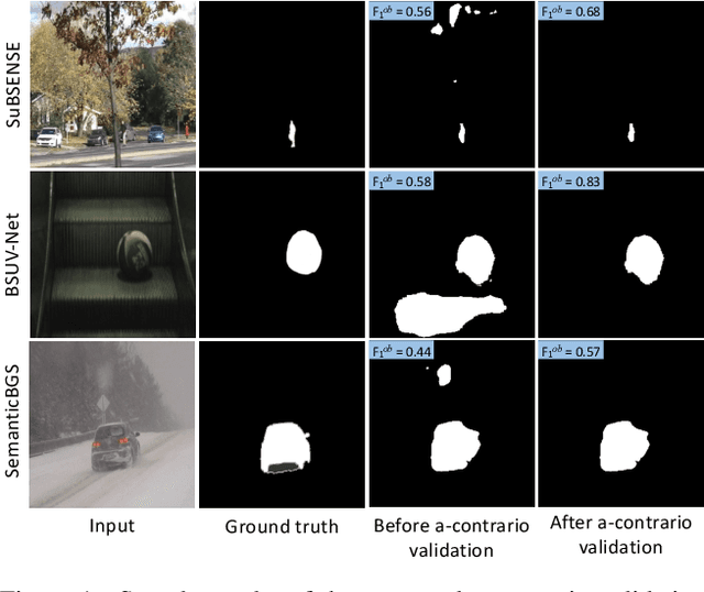
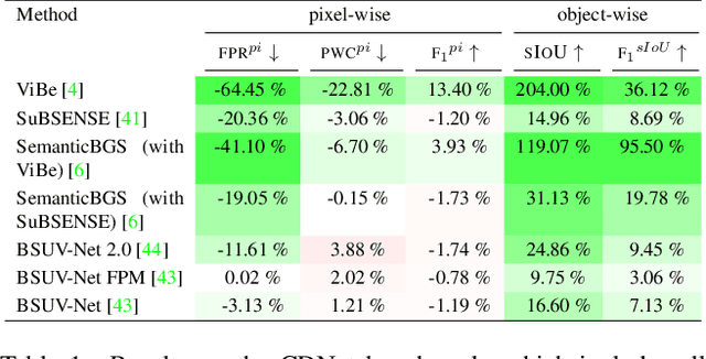
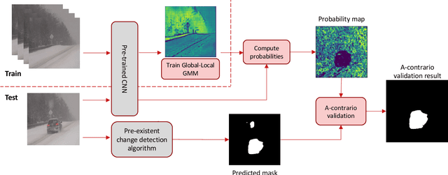
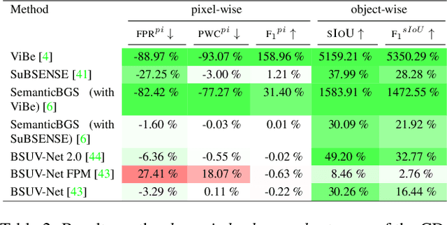
Detecting relevant changes is a fundamental problem of video surveillance. Because of the high variability of data and the difficulty of properly annotating changes, unsupervised methods dominate the field. Arguably one of the most critical issues to make them practical is to reduce their false alarm rate. In this work, we develop a method-agnostic weakly supervised a-contrario validation process, based on high dimensional statistical modeling of deep features, to reduce the number of false alarms of any change detection algorithm. We also raise the insufficiency of the conventionally used pixel-wise evaluation, as it fails to precisely capture the performance needs of most real applications. For this reason, we complement pixel-wise metrics with object-wise metrics and evaluate the impact of our approach at both pixel and object levels, on six methods and several sequences from different datasets. Experimental results reveal that the proposed a-contrario validation is able to largely reduce the number of false alarms at both pixel and object levels.