Susanne Wenzel
Ocean Eddy Identification and Tracking using Neural Networks
May 15, 2018


Abstract:Global climate change plays an essential role in our daily life. Mesoscale ocean eddies have a significant impact on global warming, since they affect the ocean dynamics, the energy as well as the mass transports of ocean circulation. From satellite altimetry we can derive high-resolution, global maps containing ocean signals with dominating coherent eddy structures. The aim of this study is the development and evaluation of a deep-learning based approach for the analysis of eddies. In detail, we develop an eddy identification and tracking framework with two different approaches that are mainly based on feature learning with convolutional neural networks. Furthermore, state-of-the-art image processing tools and object tracking methods are used to support the eddy tracking. In contrast to previous methods, our framework is able to learn a representation of the data in which eddies can be detected and tracked in more objective and robust way. We show the detection and tracking results on sea level anomalies (SLA) data from the area of Australia and the East Australia current, and compare our two eddy detection and tracking approaches to identify the most robust and objective method.
Archetypal Analysis for Sparse Representation-based Hyperspectral Sub-pixel Quantification
Feb 08, 2018


Abstract:The estimation of land cover fractions from remote sensing images is a frequently used indicator of the environmental quality. This paper focuses on the quantification of land cover fractions in an urban area of Berlin, Germany, using simulated hyperspectral EnMAP data with a spatial resolution of 30m$\times$30m. We use constrained sparse representation, where each pixel with unknown surface characteristics is expressed by a weighted linear combination of elementary spectra with known land cover class. We automatically determine the elementary spectra from image reference data using archetypal analysis by simplex volume maximization, and combine it with reversible jump Markov chain Monte Carlo method. In our experiments, the estimation of the automatically derived elementary spectra is compared to the estimation obtained by a manually designed spectral library by means of reconstruction error, mean absolute error of the fraction estimates, sum of fractions, $R^2$, and the number of used elementary spectra. The experiments show that a collection of archetypes can be an adequate and efficient alternative to the manually designed spectral library with respect to the mentioned criteria.
Deep Self-taught Learning for Remote Sensing Image Classification
Dec 19, 2017


Abstract:This paper addresses the land cover classification task for remote sensing images by deep self-taught learning. Our self-taught learning approach learns suitable feature representations of the input data using sparse representation and undercomplete dictionary learning. We propose a deep learning framework which extracts representations in multiple layers and use the output of the deepest layer as input to a classification algorithm. We evaluate our approach using a multispectral Landsat 5 TM image of a study area in the North of Novo Progresso (South America) and the Zurich Summer Data Set provided by the University of Zurich. Experiments indicate that features learned by a deep self-taught learning framework can be used for classification and improve the results compared to classification results using the original feature representation.
* This is a corrected version of the final paper published in the proceedings
Sea Level Anomaly Prediction using Recurrent Neural Networks
Oct 19, 2017


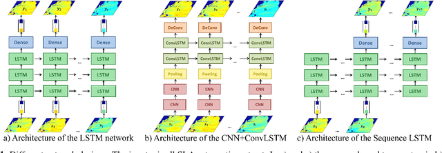
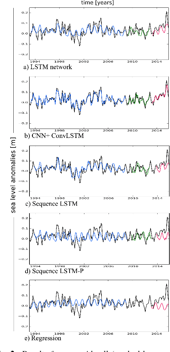
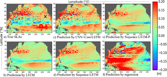
Abstract:Sea level change, one of the most dire impacts of anthropogenic global warming, will affect a large amount of the world's population. However, sea level change is not uniform in time and space, and the skill of conventional prediction methods is limited due to the ocean's internal variabi-lity on timescales from weeks to decades. Here we study the potential of neural network methods which have been used successfully in other applications, but rarely been applied for this task. We develop a combination of a convolutional neural network (CNN) and a recurrent neural network (RNN) to ana-lyse both the spatial and the temporal evolution of sea level and to suggest an independent, accurate method to predict interannual sea level anomalies (SLA). We test our method for the northern and equatorial Pacific Ocean, using gridded altimeter-derived SLA data. We show that the used network designs outperform a simple regression and that adding a CNN improves the skill significantly. The predictions are stable over several years.
 Add to Chrome
 Add to Firefox
 Add to Edge