 Add to Chrome
 Add to Firefox
 Add to Edge
Global Renewables Watch: A Temporal Dataset of Solar and Wind Energy Derived from Satellite Imagery
Mar 19, 2025We present a comprehensive global temporal dataset of commercial solar photovoltaic (PV) farms and onshore wind turbines, derived from high-resolution satellite imagery analyzed quarterly from the fourth quarter of 2017 to the second quarter of 2024. We create this dataset by training deep learning-based segmentation models to identify these renewable energy installations from satellite imagery, then deploy them on over 13 trillion pixels covering the world. For each detected feature, we estimate the construction date and the preceding land use type. This dataset offers crucial insights into progress toward sustainable development goals and serves as a valuable resource for policymakers, researchers, and stakeholders aiming to assess and promote effective strategies for renewable energy deployment. Our final spatial dataset includes 375,197 individual wind turbines and 86,410 solar PV installations. We aggregate our predictions to the country level -- estimating total power capacity based on construction date, solar PV area, and number of windmills -- and find an $r^2$ value of $0.96$ and $0.93$ for solar PV and onshore wind respectively compared to IRENA's most recent 2023 country-level capacity estimates.
An Artificial Intelligence Dataset for Solar Energy Locations in India
Jan 31, 2022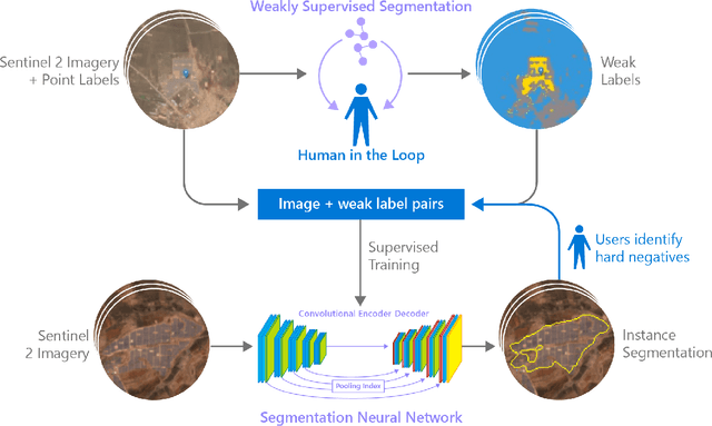

Rapid development of renewable energy sources, particularly solar photovoltaics, is critical to mitigate climate change. As a result, India has set ambitious goals to install 300 gigawatts of solar energy capacity by 2030. Given the large footprint projected to meet these renewable energy targets the potential for land use conflicts over environmental and social values is high. To expedite development of solar energy, land use planners will need access to up-to-date and accurate geo-spatial information of PV infrastructure. The majority of recent studies use either predictions of resource suitability or databases that are either developed thru crowdsourcing that often have significant sampling biases or have time lags between when projects are permitted and when location data becomes available. Here, we address this shortcoming by developing a spatially explicit machine learning model to map utility-scale solar projects across India. Using these outputs, we provide a cumulative measure of the solar footprint across India and quantified the degree of land modification associated with land cover types that may cause conflicts. Our analysis indicates that over 74\% of solar development In India was built on landcover types that have natural ecosystem preservation, and agricultural values. Thus, with a mean accuracy of 92\% this method permits the identification of the factors driving land suitability for solar projects and will be of widespread interest for studies seeking to assess trade-offs associated with the global decarbonization of green-energy systems. In the same way, our model increases the feasibility of remote sensing and long-term monitoring of renewable energy deployment targets.