Romain Husson
Collecte Localisation Satellites, Brest, France
Rainfall regression from C-band Synthetic Aperture Radar using Multi-Task Generative Adversarial Networks
Nov 05, 2024


Abstract:This paper introduces a data-driven approach to estimate precipitation rates from Synthetic Aperture Radar (SAR) at a spatial resolution of 200 meters per pixel. It addresses previous challenges related to the collocation of SAR and weather radar data, specifically the misalignment in collocations and the scarcity of rainfall examples under strong wind. To tackle these challenges, the paper proposes a multi-objective formulation, introducing patch-level components and an adversarial component. It exploits the full NEXRAD archive to look for potential co-locations with Sentinel-1 data. With additional enhancements to the training procedure and the incorporation of additional inputs, the resulting model demonstrates improved accuracy in rainfall estimates and the ability to extend its performance to scenarios up to 15 m/s.
Reduction of rain-induced errors for wind speed estimation on SAR observations using convolutional neural networks
Mar 16, 2023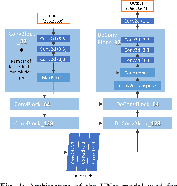
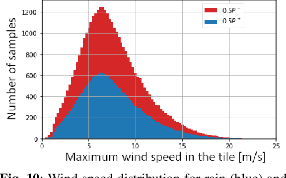
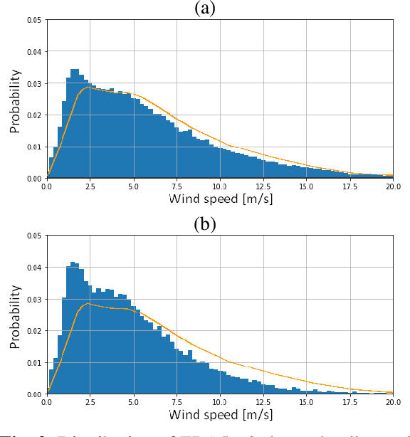
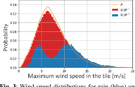
Abstract:Synthetic Aperture Radar is known to be able to provide high-resolution estimates of surface wind speed. These estimates usually rely on a Geophysical Model Function (GMF) that has difficulties accounting for non-wind processes such as rain events. Convolutional neural network, on the other hand, have the capacity to use contextual information and have demonstrated their ability to delimit rainfall areas. By carefully building a large dataset of SAR observations from the Copernicus Sentinel-1 mission, collocated with both GMF and atmospheric model wind speeds as well as rainfall estimates, we were able to train a wind speed estimator with reduced errors under rain. Collocations with in-situ wind speed measurements from buoys show a root mean square error that is reduced by 27% (resp. 45%) under rainfall estimated at more than 1 mm/h (resp. 3 mm/h). These results demonstrate the capacity of deep learning models to correct rain-related errors in SAR products.
Rain Rate Estimation with SAR using NEXRAD measurements with Convolutional Neural Networks
Jul 15, 2022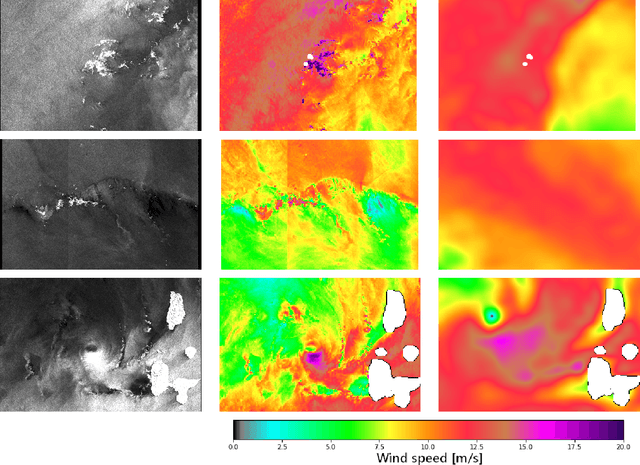
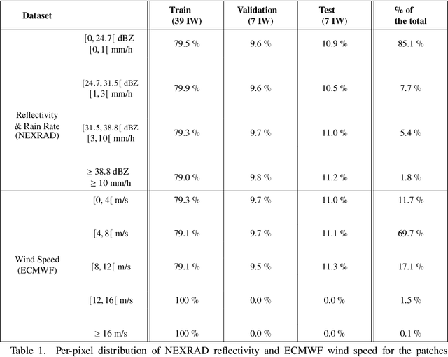
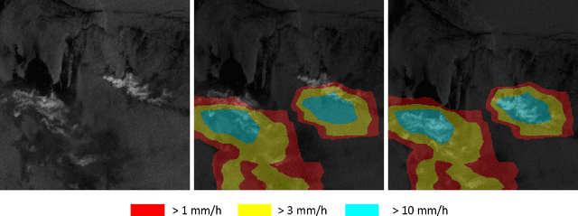
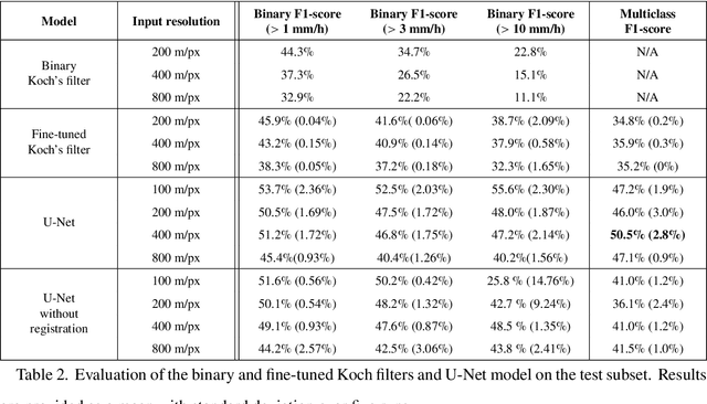
Abstract:Remote sensing of rainfall events is critical for both operational and scientific needs, including for example weather forecasting, extreme flood mitigation, water cycle monitoring, etc. Ground-based weather radars, such as NOAA's Next-Generation Radar (NEXRAD), provide reflectivity and precipitation measurements of rainfall events. However, the observation range of such radars is limited to a few hundred kilometers, prompting the exploration of other remote sensing methods, paricularly over the open ocean, that represents large areas not covered by land-based radars. For a number of decades, C-band SAR imagery such a such as Sentinel-1 imagery has been known to exhibit rainfall signatures over the sea surface. However, the development of SAR-derived rainfall products remains a challenge. Here we propose a deep learning approach to extract rainfall information from SAR imagery. We demonstrate that a convolutional neural network, such as U-Net, trained on a colocated and preprocessed Sentinel-1/NEXRAD dataset clearly outperforms state-of-the-art filtering schemes. Our results indicate high performance in segmenting precipitation regimes, delineated by thresholds at 1, 3, and 10 mm/h. Compared to current methods that rely on Koch filters to draw binary rainfall maps, these multi-threshold learning-based models can provide rainfall estimation for higher wind speeds and thus may be of great interest for data assimilation weather forecasting or for improving the qualification of SAR-derived wind field data.
 Add to Chrome
 Add to Firefox
 Add to Edge