 Add to Chrome
 Add to Firefox
 Add to Edge
A Collaborative Platform for Soil Organic Carbon Inference Based on Spatiotemporal Remote Sensing Data
Apr 17, 2025Soil organic carbon (SOC) is a key indicator of soil health, fertility, and carbon sequestration, making it essential for sustainable land management and climate change mitigation. However, large-scale SOC monitoring remains challenging due to spatial variability, temporal dynamics, and multiple influencing factors. We present WALGREEN, a platform that enhances SOC inference by overcoming limitations of current applications. Leveraging machine learning and diverse soil samples, WALGREEN generates predictive models using historical public and private data. Built on cloud-based technologies, it offers a user-friendly interface for researchers, policymakers, and land managers to access carbon data, analyze trends, and support evidence-based decision-making. Implemented in Python, Java, and JavaScript, WALGREEN integrates Google Earth Engine and Sentinel Copernicus via scripting, OpenLayers, and Thymeleaf in a Model-View-Controller framework. This paper aims to advance soil science, promote sustainable agriculture, and drive critical ecosystem responses to climate change.
Remote sensing colour image semantic segmentation of trails created by large herbivorous Mammals
Apr 16, 2025Detection of spatial areas where biodiversity is at risk is of paramount importance for the conservation and monitoring of ecosystems. Large terrestrial mammalian herbivores are keystone species as their activity not only has deep effects on soils, plants, and animals, but also shapes landscapes, as large herbivores act as allogenic ecosystem engineers. One key landscape feature that indicates intense herbivore activity and potentially impacts biodiversity is the formation of grazing trails. Grazing trails are formed by the continuous trampling activity of large herbivores that can produce complex networks of tracks of bare soil. Here, we evaluated different algorithms based on machine learning techniques to identify grazing trails. Our goal is to automatically detect potential areas with intense herbivory activity, which might be beneficial for conservation and management plans. We have applied five semantic segmentation methods combined with fourteen encoders aimed at mapping grazing trails on aerial images. Our results indicate that in most cases the chosen methodology successfully mapped the trails, although there were a few instances where the actual trail structure was underestimated. The UNet architecture with the MambaOut encoder was the best architecture for mapping trails. The proposed approach could be applied to develop tools for mapping and monitoring temporal changes in these landscape structures to support habitat conservation and land management programs. This is the first time, to the best of our knowledge, that competitive image segmentation results are obtained for the detection and delineation of trails of large herbivorous mammals.
Defect detection and segmentation in X-Ray images of magnesium alloy castings using the Detectron2 framework
Feb 28, 2022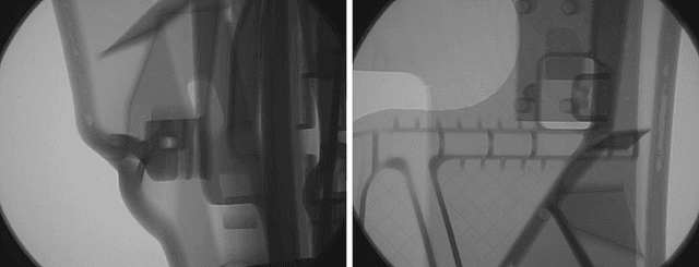
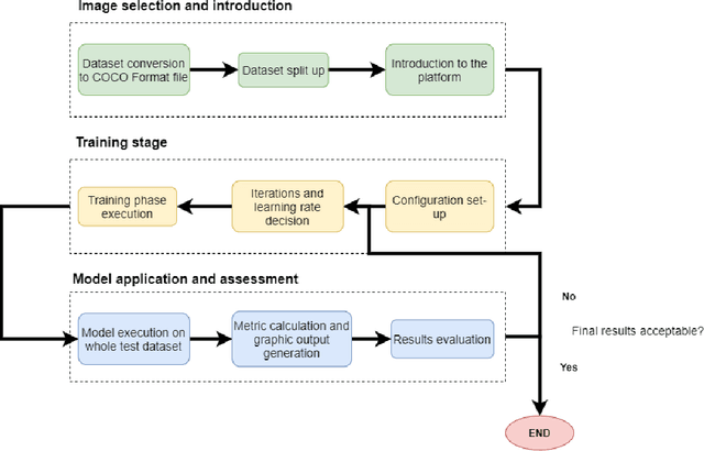
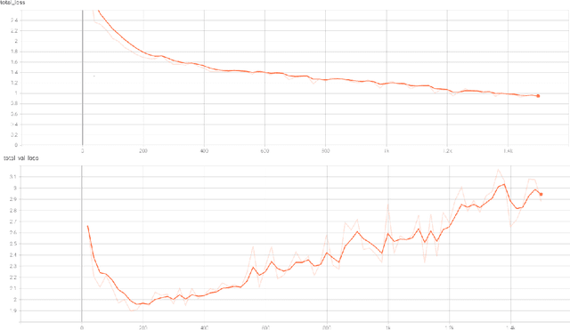
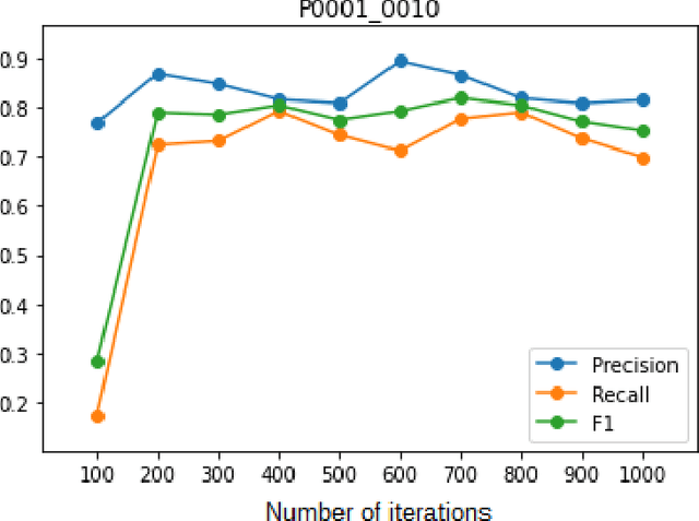
New production techniques have emerged that have made it possible to produce metal parts with more complex shapes, making the quality control process more difficult. This implies that the visual and superficial analysis has become even more inefficient. On top of that, it is also not possible to detect internal defects that these parts could have. The use of X-Ray images has made this process much easier, allowing not only to detect superficial defects in a much simpler way, but also to detect welding or casting defects that could represent a serious hazard for the physical integrity of the metal parts. On the other hand, the use of an automatic segmentation approach for detecting defects would help diminish the dependence of defect detection on the subjectivity of the factory operators and their time dependence variability. The aim of this paper is to apply a deep learning system based on Detectron2, a state-of-the-art library applied to object detection and segmentation in images, for the identification and segmentation of these defects on X-Ray images obtained mainly from automotive parts