Panagiotis Agrafiotis
Seabed-Net: A multi-task network for joint bathymetry estimation and seabed classification from remote sensing imagery in shallow waters
Oct 22, 2025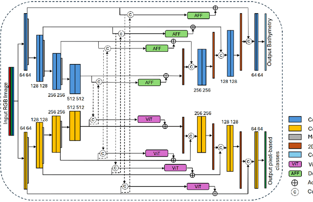
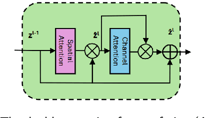
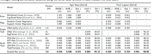
Abstract:Accurate, detailed, and regularly updated bathymetry, coupled with complex semantic content, is essential for under-mapped shallow-water environments facing increasing climatological and anthropogenic pressures. However, existing approaches that derive either depth or seabed classes from remote sensing imagery treat these tasks in isolation, forfeiting the mutual benefits of their interaction and hindering the broader adoption of deep learning methods. To address these limitations, we introduce Seabed-Net, a unified multi-task framework that simultaneously predicts bathymetry and pixel-based seabed classification from remote sensing imagery of various resolutions. Seabed-Net employs dual-branch encoders for bathymetry estimation and pixel-based seabed classification, integrates cross-task features via an Attention Feature Fusion module and a windowed Swin-Transformer fusion block, and balances objectives through dynamic task uncertainty weighting. In extensive evaluations at two heterogeneous coastal sites, it consistently outperforms traditional empirical models and traditional machine learning regression methods, achieving up to 75\% lower RMSE. It also reduces bathymetric RMSE by 10-30\% compared to state-of-the-art single-task and multi-task baselines and improves seabed classification accuracy up to 8\%. Qualitative analyses further demonstrate enhanced spatial consistency, sharper habitat boundaries, and corrected depth biases in low-contrast regions. These results confirm that jointly modeling depth with both substrate and seabed habitats yields synergistic gains, offering a robust, open solution for integrated shallow-water mapping. Code and pretrained weights are available at https://github.com/pagraf/Seabed-Net.
Sea-Undistort: A Dataset for Through-Water Image Restoration in High Resolution Airborne Bathymetric Mapping
Aug 11, 2025Abstract:Accurate image-based bathymetric mapping in shallow waters remains challenging due to the complex optical distortions such as wave induced patterns, scattering and sunglint, introduced by the dynamic water surface, the water column properties, and solar illumination. In this work, we introduce Sea-Undistort, a comprehensive synthetic dataset of 1200 paired 512x512 through-water scenes rendered in Blender. Each pair comprises a distortion-free and a distorted view, featuring realistic water effects such as sun glint, waves, and scattering over diverse seabeds. Accompanied by per-image metadata such as camera parameters, sun position, and average depth, Sea-Undistort enables supervised training that is otherwise infeasible in real environments. We use Sea-Undistort to benchmark two state-of-the-art image restoration methods alongside an enhanced lightweight diffusion-based framework with an early-fusion sun-glint mask. When applied to real aerial data, the enhanced diffusion model delivers more complete Digital Surface Models (DSMs) of the seabed, especially in deeper areas, reduces bathymetric errors, suppresses glint and scattering, and crisply restores fine seabed details. Dataset, weights, and code are publicly available at https://www.magicbathy.eu/Sea-Undistort.html.
Deep Learning-based Bathymetry Retrieval without In-situ Depths using Remote Sensing Imagery and SfM-MVS DSMs with Data Gaps
Apr 15, 2025

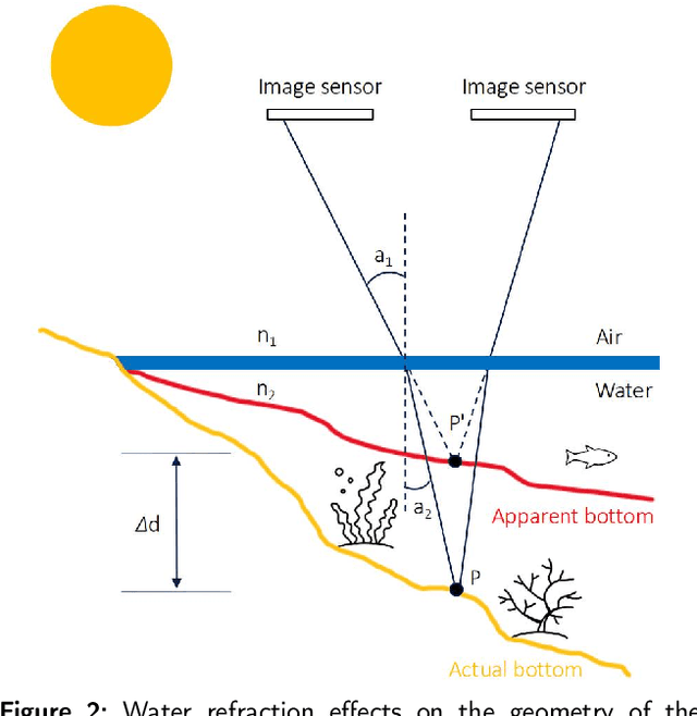

Abstract:Accurate, detailed, and high-frequent bathymetry is crucial for shallow seabed areas facing intense climatological and anthropogenic pressures. Current methods utilizing airborne or satellite optical imagery to derive bathymetry primarily rely on either SfM-MVS with refraction correction or Spectrally Derived Bathymetry (SDB). However, SDB methods often require extensive manual fieldwork or costly reference data, while SfM-MVS approaches face challenges even after refraction correction. These include depth data gaps and noise in environments with homogeneous visual textures, which hinder the creation of accurate and complete Digital Surface Models (DSMs) of the seabed. To address these challenges, this work introduces a methodology that combines the high-fidelity 3D reconstruction capabilities of the SfM-MVS methods with state-of-the-art refraction correction techniques, along with the spectral analysis capabilities of a new deep learning-based method for bathymetry prediction. This integration enables a synergistic approach where SfM-MVS derived DSMs with data gaps are used as training data to generate complete bathymetric maps. In this context, we propose Swin-BathyUNet that combines U-Net with Swin Transformer self-attention layers and a cross-attention mechanism, specifically tailored for SDB. Swin-BathyUNet is designed to improve bathymetric accuracy by capturing long-range spatial relationships and can also function as a standalone solution for standard SDB with various training depth data, independent of the SfM-MVS output. Experimental results in two completely different test sites in the Mediterranean and Baltic Seas demonstrate the effectiveness of the proposed approach through extensive experiments that demonstrate improvements in bathymetric accuracy, detail, coverage, and noise reduction in the predicted DSM. The code is available at https://github.com/pagraf/Swin-BathyUNet.
High-resolution optical and acoustic remote sensing datasets of the Puck Lagoon, Southern Baltic
Nov 13, 2024Abstract:The very shallow marine basin of Puck Lagoon in the southern Baltic Sea, on the Northern coast of Poland, hosts valuable benthic habitats and cultural heritage sites. These include, among others, protected Zostera marina meadows, one of the Baltic's major medieval harbours, a ship graveyard, and likely other submerged features that are yet to be discovered. Prior to this project, no comprehensive high-resolution remote sensing data were available for this area. This article describes the first Digital Elevation Models (DEMs) derived from a combination of airborne bathymetric LiDAR, multibeam echosounder, airborne photogrammetry and satellite imagery. These datasets also include multibeam echosounder backscatter and LiDAR intensity, allowing determination of the character and properties of the seafloor. Combined, these datasets are a vital resource for assessing and understanding seafloor morphology, benthic habitats, cultural heritage, and submerged landscapes. Given the significance of Puck Lagoon's hydrographical, ecological, geological, and archaeological environs, the high-resolution bathymetry, acquired by our project, can provide the foundation for sustainable management and informed decision-making for this area of interest.
MagicBathyNet: A Multimodal Remote Sensing Dataset for Bathymetry Prediction and Pixel-based Classification in Shallow Waters
May 24, 2024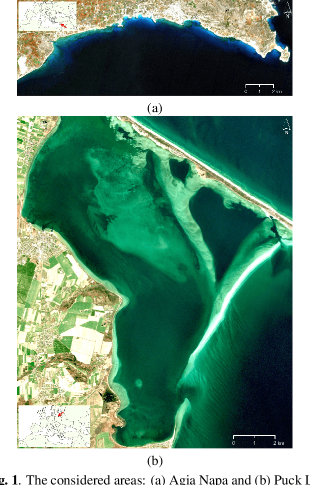
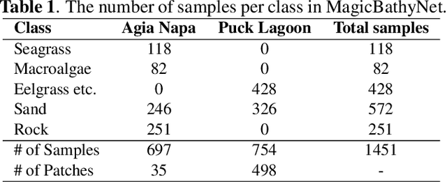

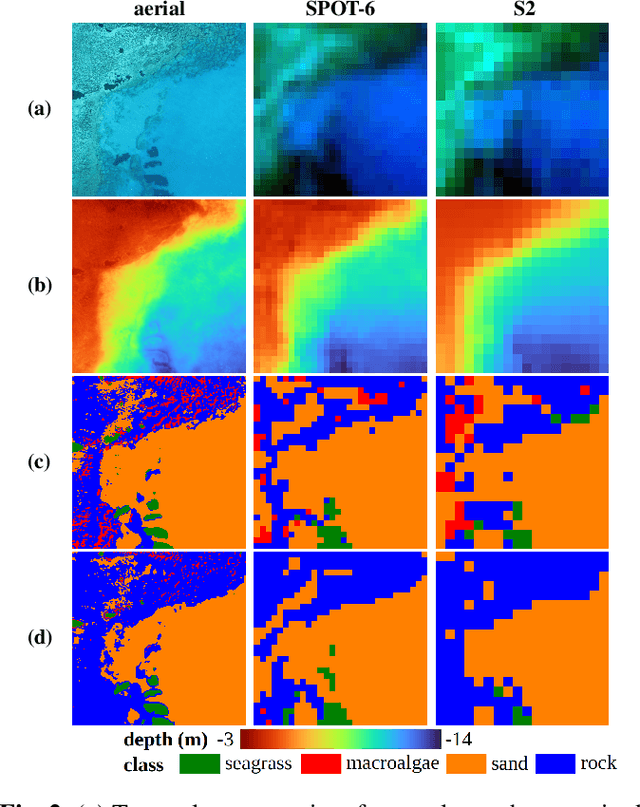
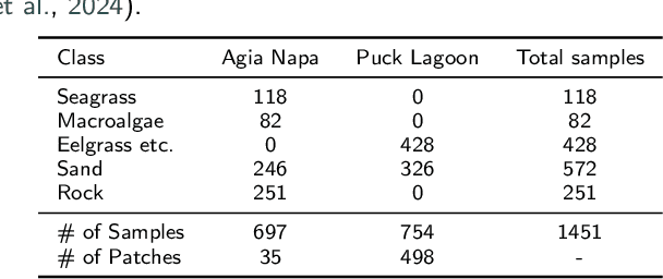
Abstract:Accurate, detailed, and high-frequent bathymetry, coupled with complex semantic content, is crucial for the undermapped shallow seabed areas facing intense climatological and anthropogenic pressures. Current methods exploiting remote sensing images to derive bathymetry or seabed classes mainly exploit non-open data. This lack of openly accessible benchmark archives prevents the wider use of deep learning methods in such applications. To address this issue, in this paper we present the MagicBathyNet, which is a benchmark dataset made up of image patches of Sentinel2, SPOT-6 and aerial imagery, bathymetry in raster format and annotations of seabed classes. MagicBathyNet is then exploited to benchmark state-of-the-art methods in learning-based bathymetry and pixel-based classification. Dataset, pre-trained weights, and code are publicly available at www.magicbathy.eu/magicbathynet.html.
Unsupervised crack detection on complex stone masonry surfaces
Mar 31, 2023Abstract:Computer vision for detecting building pathologies has interested researchers for quite some time. Vision-based crack detection is a non-destructive assessment technique, which can be useful especially for Cultural Heritage (CH) where strict regulations apply and, even simple, interventions are not permitted. Recently, shallow and deep machine learning architectures applied on various types of imagery are gaining ground. In this article a crack detection methodology for stone masonry walls is presented. In the proposed approach, crack detection is approached as an unsupervised anomaly detection problem on RGB (Red Green Blue) image patches. Towards this direction, some of the most popular state of the art CNN (Convolutional Neural Network) architectures are deployed and modified to binary classify the images or image patches by predicting a specific class for the tested imagery; 'Crack' or 'No crack', and detect and localize those cracks on the RGB imagery with high accuracy. Testing of the model was performed on various test sites and random images retrieved from the internet and collected by the authors and results suggested the high performance of specific networks compared to the rest, considering also the small numbers of epochs required for training. Those results met the accuracy delivered by more complex and computationally heavy approaches, requiring a large amount of data for training. Source code is available on GitHub https://github.com/pagraf/Crack-detection while datasets are available on Zenodo https://doi.org/10.5281/zenodo.6516913 .
Seafloor-Invariant Caustics Removal from Underwater Imagery
Dec 20, 2022


Abstract:Mapping the seafloor with underwater imaging cameras is of significant importance for various applications including marine engineering, geology, geomorphology, archaeology and biology. For shallow waters, among the underwater imaging challenges, caustics i.e., the complex physical phenomena resulting from the projection of light rays being refracted by the wavy surface, is likely the most crucial one. Caustics is the main factor during underwater imaging campaigns that massively degrade image quality and affect severely any 2D mosaicking or 3D reconstruction of the seabed. In this work, we propose a novel method for correcting the radiometric effects of caustics on shallow underwater imagery. Contrary to the state-of-the-art, the developed method can handle seabed and riverbed of any anaglyph, correcting the images using real pixel information, thus, improving image matching and 3D reconstruction processes. In particular, the developed method employs deep learning architectures in order to classify image pixels to "non-caustics" and "caustics". Then, exploits the 3D geometry of the scene to achieve a pixel-wise correction, by transferring appropriate color values between the overlapping underwater images. Moreover, to fill the current gap, we have collected, annotated and structured a real-world caustic dataset, namely R-CAUSTIC, which is openly available. Overall, based on the experimental results and validation the developed methodology is quite promising in both detecting caustics and reconstructing their intensity.
Image-based underwater 3D reconstruction for Cultural Heritage: from image collection to 3D. Critical steps and considerations
Oct 02, 2020


Abstract:Underwater Cultural Heritage (CH) sites are widely spread; from ruins in coastlines up to shipwrecks in deep. The documentation and preservation of this heritage is an obligation of the mankind, dictated also by the international treaties like the Convention on the Protection of the Underwater Cultural Her-itage which fosters the use of "non-destructive techniques and survey meth-ods in preference over the recovery of objects". However, submerged CH lacks in protection and monitoring in regards to the land CH and nowadays recording and documenting, for digital preservation as well as dissemination through VR to wide public, is of most importance. At the same time, it is most difficult to document it, due to inherent restrictions posed by the environ-ment. In order to create high detailed textured 3D models, optical sensors and photogrammetric techniques seems to be the best solution. This chapter dis-cusses critical aspects of all phases of image based underwater 3D reconstruc-tion process, from data acquisition and data preparation using colour restora-tion and colour enhancement algorithms to Structure from Motion (SfM) and Multi-View Stereo (MVS) techniques to produce an accurate, precise and complete 3D model for a number of applications.
Shallow Water Bathymetry Mapping from UAV Imagery based on Machine Learning
Feb 27, 2019


Abstract:The determination of accurate bathymetric information is a key element for near offshore activities, hydrological studies such as coastal engineering applications, sedimentary processes, hydrographic surveying as well as archaeological mapping and biological research. UAV imagery processed with Structure from Motion (SfM) and Multi View Stereo (MVS) techniques can provide a low-cost alternative to established shallow seabed mapping techniques offering as well the important visual information. Nevertheless, water refraction poses significant challenges on depth determination. Till now, this problem has been addressed through customized image-based refraction correction algorithms or by modifying the collinearity equation. In this paper, in order to overcome the water refraction errors, we employ machine learning tools that are able to learn the systematic underestimation of the estimated depths. In the proposed approach, based on known depth observations from bathymetric LiDAR surveys, an SVR model was developed able to estimate more accurately the real depths of point clouds derived from SfM-MVS procedures. Experimental results over two test sites along with the performed quantitative validation indicated the high potential of the developed approach.
 Add to Chrome
 Add to Firefox
 Add to Edge