 Add to Chrome
 Add to Firefox
 Add to Edge
Multispectral LiDAR data for extracting tree points in urban and suburban areas
Aug 27, 2025Monitoring urban tree dynamics is vital for supporting greening policies and reducing risks to electrical infrastructure. Airborne laser scanning has advanced large-scale tree management, but challenges remain due to complex urban environments and tree variability. Multispectral (MS) light detection and ranging (LiDAR) improves this by capturing both 3D spatial and spectral data, enabling detailed mapping. This study explores tree point extraction using MS-LiDAR and deep learning (DL) models. Three state-of-the-art models are evaluated: Superpoint Transformer (SPT), Point Transformer V3 (PTv3), and Point Transformer V1 (PTv1). Results show the notable time efficiency and accuracy of SPT, with a mean intersection over union (mIoU) of 85.28%. The highest detection accuracy is achieved by incorporating pseudo normalized difference vegetation index (pNDVI) with spatial data, reducing error rate by 10.61 percentage points (pp) compared to using spatial information alone. These findings highlight the potential of MS-LiDAR and DL to improve tree extraction and further tree inventories.
Multispectral airborne laser scanning for tree species classification: a benchmark of machine learning and deep learning algorithms
Apr 19, 2025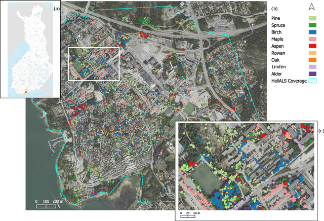
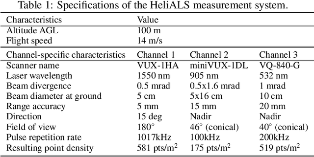
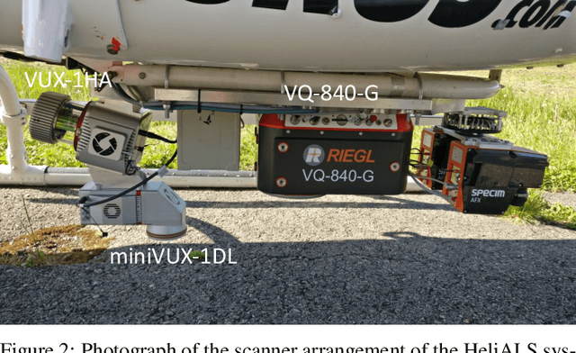
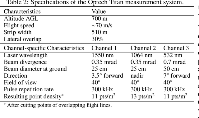
Climate-smart and biodiversity-preserving forestry demands precise information on forest resources, extending to the individual tree level. Multispectral airborne laser scanning (ALS) has shown promise in automated point cloud processing and tree segmentation, but challenges remain in identifying rare tree species and leveraging deep learning techniques. This study addresses these gaps by conducting a comprehensive benchmark of machine learning and deep learning methods for tree species classification. For the study, we collected high-density multispectral ALS data (>1000 pts/m$^2$) at three wavelengths using the FGI-developed HeliALS system, complemented by existing Optech Titan data (35 pts/m$^2$), to evaluate the species classification accuracy of various algorithms in a test site located in Southern Finland. Based on 5261 test segments, our findings demonstrate that point-based deep learning methods, particularly a point transformer model, outperformed traditional machine learning and image-based deep learning approaches on high-density multispectral point clouds. For the high-density ALS dataset, a point transformer model provided the best performance reaching an overall (macro-average) accuracy of 87.9% (74.5%) with a training set of 1065 segments and 92.0% (85.1%) with 5000 training segments. The best image-based deep learning method, DetailView, reached an overall (macro-average) accuracy of 84.3% (63.9%), whereas a random forest (RF) classifier achieved an overall (macro-average) accuracy of 83.2% (61.3%). Importantly, the overall classification accuracy of the point transformer model on the HeliALS data increased from 73.0% with no spectral information to 84.7% with single-channel reflectance, and to 87.9% with spectral information of all the three channels.
High-resolution optical and acoustic remote sensing datasets of the Puck Lagoon, Southern Baltic
Nov 13, 2024The very shallow marine basin of Puck Lagoon in the southern Baltic Sea, on the Northern coast of Poland, hosts valuable benthic habitats and cultural heritage sites. These include, among others, protected Zostera marina meadows, one of the Baltic's major medieval harbours, a ship graveyard, and likely other submerged features that are yet to be discovered. Prior to this project, no comprehensive high-resolution remote sensing data were available for this area. This article describes the first Digital Elevation Models (DEMs) derived from a combination of airborne bathymetric LiDAR, multibeam echosounder, airborne photogrammetry and satellite imagery. These datasets also include multibeam echosounder backscatter and LiDAR intensity, allowing determination of the character and properties of the seafloor. Combined, these datasets are a vital resource for assessing and understanding seafloor morphology, benthic habitats, cultural heritage, and submerged landscapes. Given the significance of Puck Lagoon's hydrographical, ecological, geological, and archaeological environs, the high-resolution bathymetry, acquired by our project, can provide the foundation for sustainable management and informed decision-making for this area of interest.