Majid Ezzati
City-Wide Perceptions of Neighbourhood Quality using Street View Images
Nov 24, 2022


Abstract:The interactions of individuals with city neighbourhoods is determined, in part, by the perceived quality of urban environments. Perceived neighbourhood quality is a core component of urban vitality, influencing social cohesion, sense of community, safety, activity and mental health of residents. Large-scale assessment of perceptions of neighbourhood quality was pioneered by the Place Pulse projects. Researchers demonstrated the efficacy of crowd-sourcing perception ratings of image pairs across 56 cities and training a model to predict perceptions from street-view images. Variation across cities may limit Place Pulse's usefulness for assessing within-city perceptions. In this paper, we set forth a protocol for city-specific dataset collection for the perception: 'On which street would you prefer to walk?'. This paper describes our methodology, based in London, including collection of images and ratings, web development, model training and mapping. Assessment of within-city perceptions of neighbourhoods can identify inequities, inform planning priorities, and identify temporal dynamics. Code available: https://emilymuller1991.github.io/urban-perceptions/.
Deep Transfer Learning on Satellite Imagery Improves Air Quality Estimates in Developing Nations
Feb 17, 2022


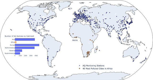
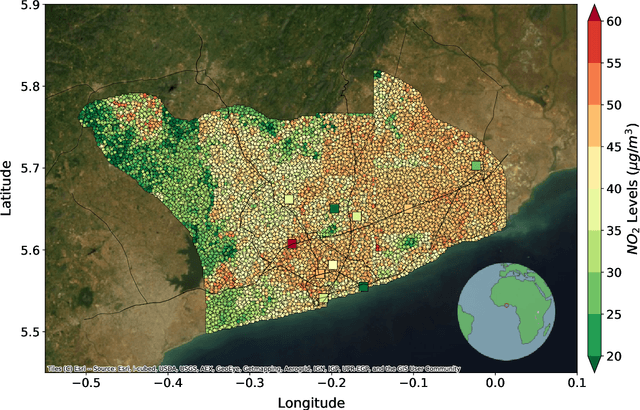
Abstract:Urban air pollution is a public health challenge in low- and middle-income countries (LMICs). However, LMICs lack adequate air quality (AQ) monitoring infrastructure. A persistent challenge has been our inability to estimate AQ accurately in LMIC cities, which hinders emergency preparedness and risk mitigation. Deep learning-based models that map satellite imagery to AQ can be built for high-income countries (HICs) with adequate ground data. Here we demonstrate that a scalable approach that adapts deep transfer learning on satellite imagery for AQ can extract meaningful estimates and insights in LMIC cities based on spatiotemporal patterns learned in HIC cities. The approach is demonstrated for Accra in Ghana, Africa, with AQ patterns learned from two US cities, specifically Los Angeles and New York.
 Add to Chrome
 Add to Firefox
 Add to Edge