Lukas Haas
DeepSearchQA: Bridging the Comprehensiveness Gap for Deep Research Agents
Jan 28, 2026Abstract:We introduce DeepSearchQA, a 900-prompt benchmark for evaluating agents on difficult multi-step information-seeking tasks across 17 different fields. Unlike traditional benchmarks that target single answer retrieval or broad-spectrum factuality, DeepSearchQA features a dataset of challenging, handcrafted tasks designed to evaluate an agent's ability to execute complex search plans to generate exhaustive answer lists. This shift in design explicitly tests three critical, yet under-evaluated capabilities: 1) systematic collation of fragmented information from disparate sources, 2) de-duplication and entity resolution to ensure precision, and 3) the ability to reason about stopping criteria within an open-ended search space. Each task is structured as a causal chain, where discovering information for one step is dependent on the successful completion of the previous one, stressing long-horizon planning and context retention. All tasks are grounded in the open web with objectively verifiable answer sets. Our comprehensive evaluation of state-of-the-art agent architectures reveals significant performance limitations: even the most advanced models struggle to balance high recall with precision. We observe distinct failure modes ranging from premature stopping (under-retrieval) to hedging behaviors, where agents cast an overly wide net of low-confidence answers to artificially boost recall. These findings highlight critical headroom in current agent designs and position DeepSearchQA as an essential diagnostic tool for driving future research toward more robust, deep-research capabilities.
The FACTS Leaderboard: A Comprehensive Benchmark for Large Language Model Factuality
Dec 11, 2025Abstract:We introduce The FACTS Leaderboard, an online leaderboard suite and associated set of benchmarks that comprehensively evaluates the ability of language models to generate factually accurate text across diverse scenarios. The suite provides a holistic measure of factuality by aggregating the performance of models on four distinct sub-leaderboards: (1) FACTS Multimodal, which measures the factuality of responses to image-based questions; (2) FACTS Parametric, which assesses models' world knowledge by answering closed-book factoid questions from internal parameters; (3) FACTS Search, which evaluates factuality in information-seeking scenarios, where the model must use a search API; and (4) FACTS Grounding (v2), which evaluates whether long-form responses are grounded in provided documents, featuring significantly improved judge models. Each sub-leaderboard employs automated judge models to score model responses, and the final suite score is an average of the four components, designed to provide a robust and balanced assessment of a model's overall factuality. The FACTS Leaderboard Suite will be actively maintained, containing both public and private splits to allow for external participation while guarding its integrity. It can be found at https://www.kaggle.com/benchmarks/google/facts .
SimpleQA Verified: A Reliable Factuality Benchmark to Measure Parametric Knowledge
Sep 09, 2025


Abstract:We introduce SimpleQA Verified, a 1,000-prompt benchmark for evaluating Large Language Model (LLM) short-form factuality based on OpenAI's SimpleQA. It addresses critical limitations in OpenAI's benchmark, including noisy and incorrect labels, topical biases, and question redundancy. SimpleQA Verified was created through a rigorous multi-stage filtering process involving de-duplication, topic balancing, and source reconciliation to produce a more reliable and challenging evaluation set, alongside improvements in the autorater prompt. On this new benchmark, Gemini 2.5 Pro achieves a state-of-the-art F1-score of 55.6, outperforming other frontier models, including GPT-5. This work provides the research community with a higher-fidelity tool to track genuine progress in parametric model factuality and to mitigate hallucinations. The benchmark dataset, evaluation code, and leaderboard are available at: https://www.kaggle.com/benchmarks/deepmind/simpleqa-verified.
The FACTS Grounding Leaderboard: Benchmarking LLMs' Ability to Ground Responses to Long-Form Input
Jan 06, 2025


Abstract:We introduce FACTS Grounding, an online leaderboard and associated benchmark that evaluates language models' ability to generate text that is factually accurate with respect to given context in the user prompt. In our benchmark, each prompt includes a user request and a full document, with a maximum length of 32k tokens, requiring long-form responses. The long-form responses are required to be fully grounded in the provided context document while fulfilling the user request. Models are evaluated using automated judge models in two phases: (1) responses are disqualified if they do not fulfill the user request; (2) they are judged as accurate if the response is fully grounded in the provided document. The automated judge models were comprehensively evaluated against a held-out test-set to pick the best prompt template, and the final factuality score is an aggregate of multiple judge models to mitigate evaluation bias. The FACTS Grounding leaderboard will be actively maintained over time, and contains both public and private splits to allow for external participation while guarding the integrity of the leaderboard. It can be found at https://www.kaggle.com/facts-leaderboard.
PIGEON: Predicting Image Geolocations
Jul 13, 2023


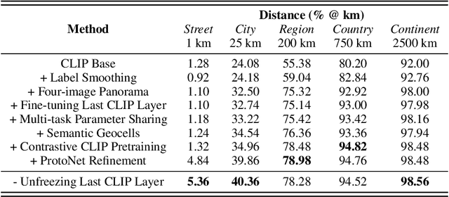
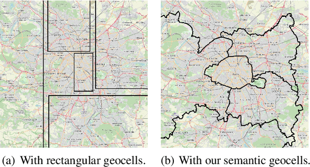
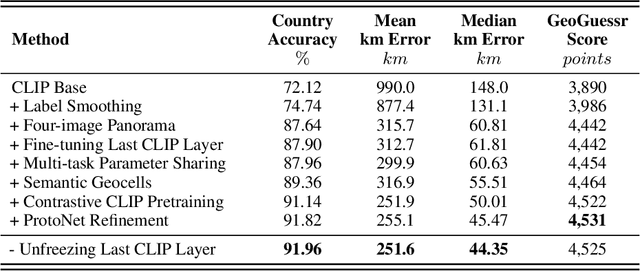
Abstract:We introduce PIGEON, a multi-task end-to-end system for planet-scale image geolocalization that achieves state-of-the-art performance on both external benchmarks and in human evaluation. Our work incorporates semantic geocell creation with label smoothing, conducts pretraining of a vision transformer on images with geographic information, and refines location predictions with ProtoNets across a candidate set of geocells. The contributions of PIGEON are three-fold: first, we design a semantic geocells creation and splitting algorithm based on open-source data which can be adapted to any geospatial dataset. Second, we show the effectiveness of intra-geocell refinement and the applicability of unsupervised clustering and ProtNets to the task. Finally, we make our pre-trained CLIP transformer model, StreetCLIP, publicly available for use in adjacent domains with applications to fighting climate change and urban and rural scene understanding.
Learning Generalized Zero-Shot Learners for Open-Domain Image Geolocalization
Feb 01, 2023Abstract:Image geolocalization is the challenging task of predicting the geographic coordinates of origin for a given photo. It is an unsolved problem relying on the ability to combine visual clues with general knowledge about the world to make accurate predictions across geographies. We present $\href{https://huggingface.co/geolocal/StreetCLIP}{\text{StreetCLIP}}$, a robust, publicly available foundation model not only achieving state-of-the-art performance on multiple open-domain image geolocalization benchmarks but also doing so in a zero-shot setting, outperforming supervised models trained on more than 4 million images. Our method introduces a meta-learning approach for generalized zero-shot learning by pretraining CLIP from synthetic captions, grounding CLIP in a domain of choice. We show that our method effectively transfers CLIP's generalized zero-shot capabilities to the domain of image geolocalization, improving in-domain generalized zero-shot performance without finetuning StreetCLIP on a fixed set of classes.
Estimating Building Energy Efficiency From Street View Imagery, Aerial Imagery, and Land Surface Temperature Data
Jun 05, 2022


Abstract:In the race towards carbon neutrality, the building sector has fallen behind and bears the potential to endanger the progress made across other industries. This is because buildings exhibit a life span of several decades which creates substantial inertia in the face of climate change. This inertia is further exacerbated by the scale of the existing building stock. With several billion operational buildings around the globe, working towards a carbon-neutral building sector requires solutions which enable stakeholders to accurately identify and retrofit subpar buildings at scale. However, improving the energy efficiency of the existing building stock through retrofits in a targeted and efficient way remains challenging. This is because, as of today, the energy efficiency of buildings is generally determined by on-site visits of certified energy auditors which makes the process slow, costly, and geographically incomplete. In order to accelerate the identification of promising retrofit targets, this work proposes a new method which can estimate a building's energy efficiency using purely remotely sensed data such as street view and aerial imagery, OSM-derived footprint areas, and satellite-borne land surface temperature (LST) measurements. We find that in the binary setting of distinguishing efficient from inefficient buildings, our end-to-end deep learning model achieves a macro-averaged F1-score of 62.06\%. As such, this work shows the potential and complementary nature of remotely sensed data in predicting building attributes such as energy efficiency and opens up new opportunities for future work to integrate additional data sources.
 Add to Chrome
 Add to Firefox
 Add to Edge