Luigi Russo
A Deep Learning Architecture for Land Cover Mapping Using Spatio-Temporal Sentinel-1 Features
Mar 10, 2025
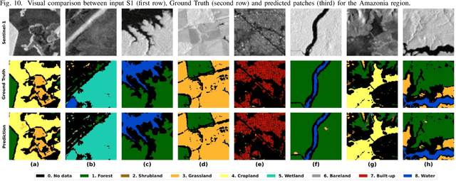
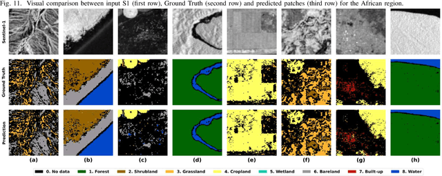
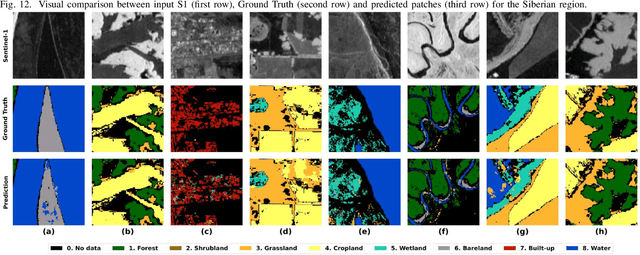
Abstract:Land Cover (LC) mapping using satellite imagery is critical for environmental monitoring and management. Deep Learning (DL), particularly Convolutional Neural Networks (CNNs) and Vision Transformers (ViTs), have revolutionized this field by enhancing the accuracy of classification tasks. In this work, a novel approach combining a transformer-based Swin-Unet architecture with seasonal synthesized spatio-temporal images has been employed to classify LC types using spatio-temporal features extracted from Sentinel-1 (S1) Synthetic Aperture Radar (SAR) data, organized into seasonal clusters. The study focuses on three distinct regions - Amazonia, Africa, and Siberia - and evaluates the model performance across diverse ecoregions within these areas. By utilizing seasonal feature sequences instead of dense temporal sequences, notable performance improvements have been achieved, especially in regions with temporal data gaps like Siberia, where S1 data distribution is uneven and non-uniform. The results demonstrate the effectiveness and the generalization capabilities of the proposed methodology in achieving high overall accuracy (O.A.) values, even in regions with limited training data.
SEN12-WATER: A New Dataset for Hydrological Applications and its Benchmarking
Sep 25, 2024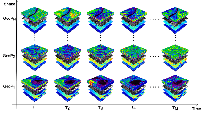
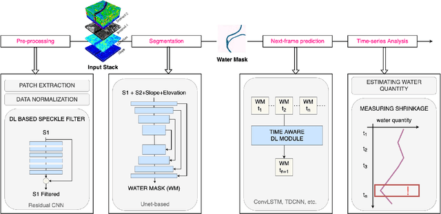
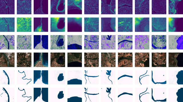
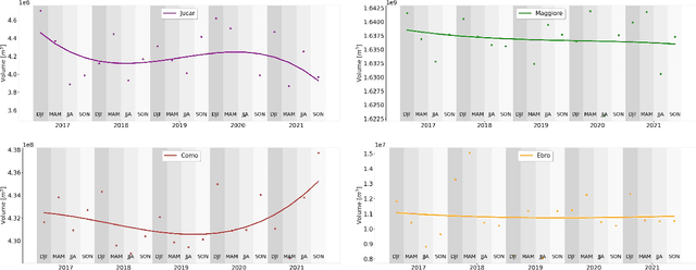
Abstract:Climate change and increasing droughts pose significant challenges to water resource management around the world. These problems lead to severe water shortages that threaten ecosystems, agriculture, and human communities. To advance the fight against these challenges, we present a new dataset, SEN12-WATER, along with a benchmark using a novel end-to-end Deep Learning (DL) framework for proactive drought-related analysis. The dataset, identified as a spatiotemporal datacube, integrates SAR polarization, elevation, slope, and multispectral optical bands. Our DL framework enables the analysis and estimation of water losses over time in reservoirs of interest, revealing significant insights into water dynamics for drought analysis by examining temporal changes in physical quantities such as water volume. Our methodology takes advantage of the multitemporal and multimodal characteristics of the proposed dataset, enabling robust generalization and advancing understanding of drought, contributing to climate change resilience and sustainable water resource management. The proposed framework involves, among the several components, speckle noise removal from SAR data, a water body segmentation through a U-Net architecture, the time series analysis, and the predictive capability of a Time-Distributed-Convolutional Neural Network (TD-CNN). Results are validated through ground truth data acquired on-ground via dedicated sensors and (tailored) metrics, such as Precision, Recall, Intersection over Union, Mean Squared Error, Structural Similarity Index Measure and Peak Signal-to-Noise Ratio.
Estimation of Ground NO2 Measurements from Sentinel-5P Tropospheric Data through Categorical Boosting
Apr 08, 2023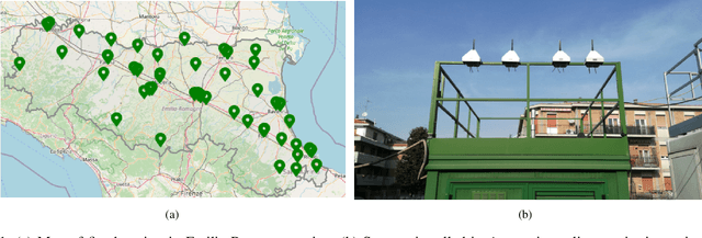
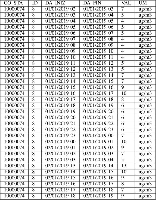
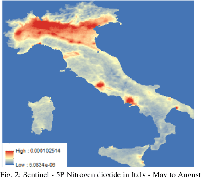

Abstract:Atmospheric pollution has been largely considered by the scientific community as a primary threat to human health and ecosystems, above all for its impact on climate change. Therefore, its containment and reduction are gaining interest and commitment from institutions and researchers, although the solutions are not immediate. It becomes of primary importance to identify the distribution of air pollutants and evaluate their concentration levels in order to activate the right countermeasures. Among other tools, satellite-based measurements have been used for monitoring and obtaining information on air pollutants, and over the years their performance has increased in terms of both resolution and data reliability. This study aims to analyze the NO2 pollution in the Emilia Romagna Region (Northern Italy) during 2019, with the help of satellite retrievals from the {\nobreak Sentinel\nobreak-5P} mission of the European Copernicus Programme and ground-based measurements, obtained from the ARPA site (Regional Agency for the Protection of the Environment). The final goal is the estimation of ground NO2 measurements when only satellite data are available. For this task, we used a Machine Learning (ML) model, Categorical Boosting, which was demonstrated to work quite well and allowed us to achieve a Root-Mean-Square Error (RMSE) of 0.0242 over the 43 stations utilized to get the Ground Truth values. This procedure, applicable to other areas of Italy and the world and on longer timelines, represents the starting point to understand which other actions must be taken to improve its final performance.
A Vision-Based Algorithm for a Path Following Problem
Feb 09, 2023Abstract:A novel prize-winner algorithm designed for a path following problem within the Unmanned Aerial Vehicle (UAV) field is presented in this paper. The proposed approach exploits the advantages offered by the pure pursuing algorithm to set up an intuitive and simple control framework. A path fora quad-rotor UAV is obtained by using downward facing camera images implementing an Image-Based Visual Servoing (IBVS) approach. Numerical simulations in MATLAB together with the MathWorks Virtual Reality (VR) toolbox demonstrate the validity and the effectiveness of the proposed solution. The code is released as open-source making it possible to go through any part of the system and to replicate the obtained results.
* 6 pages, 11 figures, conference
 Add to Chrome
 Add to Firefox
 Add to Edge