Kieran M. R. Hunt
Hydra-LSTM: A semi-shared Machine Learning architecture for prediction across Watersheds
Oct 21, 2024


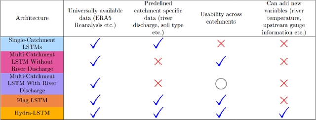
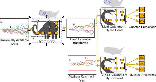
Abstract:Long Short Term Memory networks (LSTMs) are used to build single models that predict river discharge across many catchments. These models offer greater accuracy than models trained on each catchment independently if using the same data. However, the same data is rarely available for all catchments. This prevents the use of variables available only in some catchments, such as historic river discharge or upstream discharge. The only existing method that allows for optional variables requires all variables to be considered in the initial training of the model, limiting its transferability to new catchments. To address this limitation, we develop the Hydra-LSTM. The Hydra-LSTM processes variables used across all catchments and variables used in only some catchments separately to allow general training and use of catchment-specific data in individual catchments. The bulk of the model can be shared across catchments, maintaining the benefits of multi-catchment models to generalise, while also benefitting from the advantages of using bespoke data. We apply this methodology to 1 day-ahead river discharge prediction in the Western US, as next-day river discharge prediction is the first step towards prediction across longer time scales. We obtain state-of-the-art performance, generating more accurate median and quantile predictions than Multi-Catchment and Single-Catchment LSTMs while allowing local forecasters to easily introduce and remove variables from their prediction set. We test the ability of the Hydra-LSTM to incorporate catchment-specific data by introducing historical river discharge as a catchment-specific input, outperforming state-of-the-art models without needing to train an entirely new model.
Do AI models produce better weather forecasts than physics-based models? A quantitative evaluation case study of Storm Ciarán
Dec 05, 2023


Abstract:There has been huge recent interest in the potential of making operational weather forecasts using machine learning techniques. As they become a part of the weather forecasting toolbox, there is a pressing need to understand how well current machine learning models can simulate high-impactweather events. We compare forecasts of Storm Ciar\'an, a European windstorm that caused sixteen deaths and extensive damage in Northern Europe, made by machine learning and numericalweather prediction models. The four machine learning models considered (FourCastNet, Pangu-Weather, GraphCast and FourCastNet-v2) produce forecasts that accurately capture the synoptic-scale structure of the cyclone including the position of the cloud head, shape of the warm sector and location of warm conveyor belt jet, and the large-scale dynamical drivers important for the rapid storm development such as the position of the storm relative to the upper-level jet exit. However, their ability to resolve the more detailed structures important for issuing weather warnings is more mixed. All of the machine learning models underestimate the peak amplitude of winds associated with the storm, only some machine learning models resolve the warm core seclusion and none of the machine learning models capture the sharp bent-back warm frontal gradient. Our study shows there is a great deal about the performance and properties of machine learning weather forecasts that can be derived from case studies of high-impact weather events such as Storm Ciar\'an.
 Add to Chrome
 Add to Firefox
 Add to Edge