 Add to Chrome
 Add to Firefox
 Add to Edge
From Global to Local: Cluster-Aware Learning for Wi-Fi Fingerprinting Indoor Localisation
Jan 09, 2026Wi-Fi fingerprinting remains one of the most practical solutions for indoor positioning, however, its performance is often limited by the size and heterogeneity of fingerprint datasets, strong Received Signal Strength Indicator variability, and the ambiguity introduced in large and multi-floor environments. These factors significantly degrade localisation accuracy, particularly when global models are applied without considering structural constraints. This paper introduces a clustering-based method that structures the fingerprint dataset prior to localisation. Fingerprints are grouped using either spatial or radio features, and clustering can be applied at the building or floor level. In the localisation phase, a clustering estimation procedure based on the strongest access points assigns unseen fingerprints to the most relevant cluster. Localisation is then performed only within the selected clusters, allowing learning models to operate on reduced and more coherent subsets of data. The effectiveness of the method is evaluated on three public datasets and several machine learning models. Results show a consistent reduction in localisation errors, particularly under building-level strategies, but at the cost of reducing the floor detection accuracy. These results demonstrate that explicitly structuring datasets through clustering is an effective and flexible approach for scalable indoor positioning.
A zone-based training approach for last-mile routing using Graph Neural Networks and Pointer Networks
Jan 08, 2026Rapid e-commerce growth has pushed last-mile delivery networks to their limits, where small routing gains translate into lower costs, faster service, and fewer emissions. Classical heuristics struggle to adapt when travel times are highly asymmetric (e.g., one-way streets, congestion). A deep learning-based approach to the last-mile routing problem is presented to generate geographical zones composed of stop sequences to minimize last-mile delivery times. The presented approach is an encoder-decoder architecture. Each route is represented as a complete directed graph whose nodes are stops and whose edge weights are asymmetric travel times. A Graph Neural Network encoder produces node embeddings that captures the spatial relationships between stops. A Pointer Network decoder then takes the embeddings and the route's start node to sequentially select the next stops, assigning a probability to each unvisited node as the next destination. Cells of a Discrete Global Grid System which contain route stops in the training data are obtained and clustered to generate geographical zones of similar size in which the process of training and inference are divided. Subsequently, a different instance of the model is trained per zone only considering the stops of the training routes which are included in that zone. This approach is evaluated using the Los Angeles routes from the 2021 Amazon Last Mile Routing Challenge. Results from general and zone-based training are compared, showing a reduction in the average predicted route length in the zone-based training compared to the general training. The performance improvement of the zone-based approach becomes more pronounced as the number of stops per route increases.
SURIMI: Supervised Radio Map Augmentation with Deep Learning and a Generative Adversarial Network for Fingerprint-based Indoor Positioning
Jul 13, 2022


Indoor Positioning based on Machine Learning has drawn increasing attention both in the academy and the industry as meaningful information from the reference data can be extracted. Many researchers are using supervised, semi-supervised, and unsupervised Machine Learning models to reduce the positioning error and offer reliable solutions to the end-users. In this article, we propose a new architecture by combining Convolutional Neural Network (CNN), Long short-term memory (LSTM) and Generative Adversarial Network (GAN) in order to increase the training data and thus improve the position accuracy. The proposed combination of supervised and unsupervised models was tested in 17 public datasets, providing an extensive analysis of its performance. As a result, the positioning error has been reduced in more than 70% of them.
Data Cleansing for Indoor Positioning Wi-Fi Fingerprinting Datasets
May 04, 2022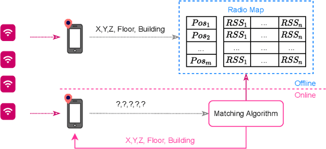

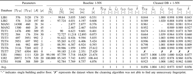
Wearable and IoT devices requiring positioning and localisation services grow in number exponentially every year. This rapid growth also produces millions of data entries that need to be pre-processed prior to being used in any indoor positioning system to ensure the data quality and provide a high Quality of Service (QoS) to the end-user. In this paper, we offer a novel and straightforward data cleansing algorithm for WLAN fingerprinting radio maps. This algorithm is based on the correlation among fingerprints using the Received Signal Strength (RSS) values and the Access Points (APs)'s identifier. We use those to compute the correlation among all samples in the dataset and remove fingerprints with low level of correlation from the dataset. We evaluated the proposed method on 14 independent publicly-available datasets. As a result, an average of 14% of fingerprints were removed from the datasets. The 2D positioning error was reduced by 2.7% and 3D positioning error by 5.3% with a slight increase in the floor hit rate by 1.2% on average. Consequently, the average speed of position prediction was also increased by 14%.
Lightweight Hybrid CNN-ELM Model for Multi-building and Multi-floor Classification
Apr 21, 2022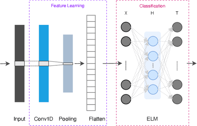
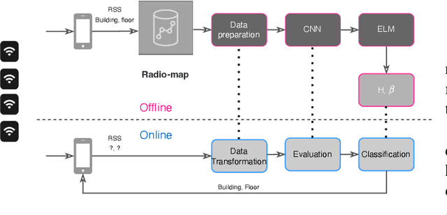


Machine learning models have become an essential tool in current indoor positioning solutions, given their high capabilities to extract meaningful information from the environment. Convolutional neural networks (CNNs) are one of the most used neural networks (NNs) due to that they are capable of learning complex patterns from the input data. Another model used in indoor positioning solutions is the Extreme Learning Machine (ELM), which provides an acceptable generalization performance as well as a fast speed of learning. In this paper, we offer a lightweight combination of CNN and ELM, which provides a quick and accurate classification of building and floor, suitable for power and resource-constrained devices. As a result, the proposed model is 58\% faster than the benchmark, with a slight improvement in the classification accuracy (by less than 1\%