 Add to Chrome
 Add to Firefox
 Add to Edge
Deep Learning-Based UAV Aerial Triangulation without Image Control Points
Jan 07, 2023


The emerging drone aerial survey has the advantages of low cost, high efficiency, and flexible use. However, UAVs are often equipped with cheap POS systems and non-measurement cameras, and their flight attitudes are easily affected. How to realize the large-scale mapping of UAV image-free control supported by POS faces many technical problems. The most basic and important core technology is how to accurately realize the absolute orientation of images through advanced aerial triangulation technology. In traditional aerial triangulation, image matching algorithms are constrained to varying degrees by preset prior knowledge. In recent years, deep learning has developed rapidly in the field of photogrammetric computer vision. It has surpassed the performance of traditional handcrafted features in many aspects. It has shown stronger stability in image-based navigation and positioning tasks, especially it has better resistance to unfavorable factors such as blur, illumination changes, and geometric distortion. Based on the introduction of the key technologies of aerial triangulation without image control points, this paper proposes a new drone image registration method based on deep learning image features to solve the problem of high mismatch rate in traditional methods. It adopts SuperPoint as the feature detector, uses the superior generalization performance of CNN to extract precise feature points from the UAV image, thereby achieving high-precision aerial triangulation. Experimental results show that under the same pre-processing and post-processing conditions, compared with the traditional method based on the SIFT algorithm, this method achieves suitable precision more efficiently, which can meet the requirements of UAV aerial triangulation without image control points in large-scale surveys.
Combining Photogrammetric Computer Vision and Semantic Segmentation for Fine-grained Understanding of Coral Reef Growth under Climate Change
Dec 08, 2022

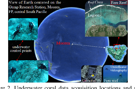
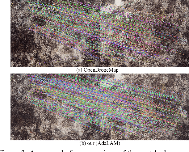
Corals are the primary habitat-building life-form on reefs that support a quarter of the species in the ocean. A coral reef ecosystem usually consists of reefs, each of which is like a tall building in any city. These reef-building corals secrete hard calcareous exoskeletons that give them structural rigidity, and are also a prerequisite for our accurate 3D modeling and semantic mapping using advanced photogrammetric computer vision and machine learning. Underwater videography as a modern underwater remote sensing tool is a high-resolution coral habitat survey and mapping technique. In this paper, detailed 3D mesh models, digital surface models and orthophotos of the coral habitat are generated from the collected coral images and underwater control points. Meanwhile, a novel pixel-wise semantic segmentation approach of orthophotos is performed by advanced deep learning. Finally, the semantic map is mapped into 3D space. For the first time, 3D fine-grained semantic modeling and rugosity evaluation of coral reefs have been completed at millimeter (mm) accuracy. This provides a new and powerful method for understanding the processes and characteristics of coral reef change at high spatial and temporal resolution under climate change.