 Add to Chrome
 Add to Firefox
 Add to Edge
Do Superpixel Segmentation Methods Influence Deforestation Image Classification?
Oct 06, 2025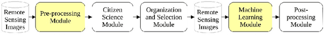
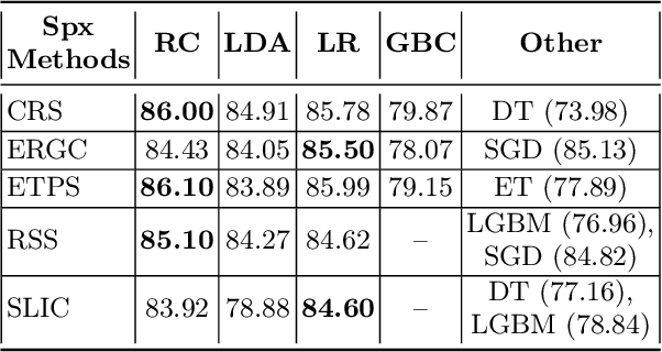
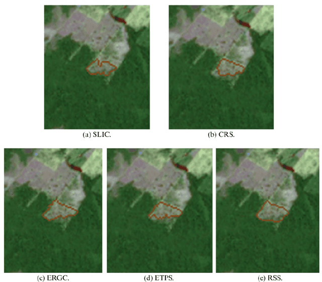
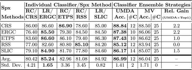
Image segmentation is a crucial step in various visual applications, including environmental monitoring through remote sensing. In the context of the ForestEyes project, which combines citizen science and machine learning to detect deforestation in tropical forests, image segments are used for labeling by volunteers and subsequent model training. Traditionally, the Simple Linear Iterative Clustering (SLIC) algorithm is adopted as the segmentation method. However, recent studies have indicated that other superpixel-based methods outperform SLIC in remote sensing image segmentation, and might suggest that they are more suitable for the task of detecting deforested areas. In this sense, this study investigated the impact of the four best segmentation methods, together with SLIC, on the training of classifiers for the target application. Initially, the results showed little variation in performance among segmentation methods, even when selecting the top five classifiers using the PyCaret AutoML library. However, by applying a classifier fusion approach (ensemble of classifiers), noticeable improvements in balanced accuracy were observed, highlighting the importance of both the choice of segmentation method and the combination of machine learning-based models for deforestation detection tasks.
Exploring Superpixel Segmentation Methods in the Context of Citizen Science and Deforestation Detection
Nov 26, 2024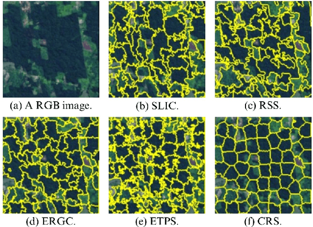
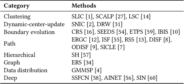
Tropical forests play an essential role in the planet's ecosystem, making the conservation of these biomes a worldwide priority. However, ongoing deforestation and degradation pose a significant threat to their existence, necessitating effective monitoring and the proposal of actions to mitigate the damage caused by these processes. In this regard, initiatives range from government and private sector monitoring programs to solutions based on citizen science campaigns, for example. Particularly in the context of citizen science campaigns, the segmentation of remote sensing images to identify deforested areas and subsequently submit them to analysis by non-specialized volunteers is necessary. Thus, segmentation using superpixel-based techniques proves to be a viable solution for this important task. Therefore, this paper presents an analysis of 22 superpixel-based segmentation methods applied to remote sensing images, aiming to identify which of them are more suitable for generating segments for citizen science campaigns. The results reveal that seven of the segmentation methods outperformed the baseline method (SLIC) currently employed in the ForestEyes citizen science project, indicating an opportunity for improvement in this important stage of campaign development.
Sampling Strategies based on Wisdom of Crowds for Amazon Deforestation Detection
Aug 22, 2024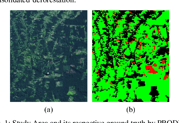
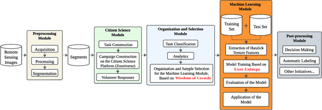
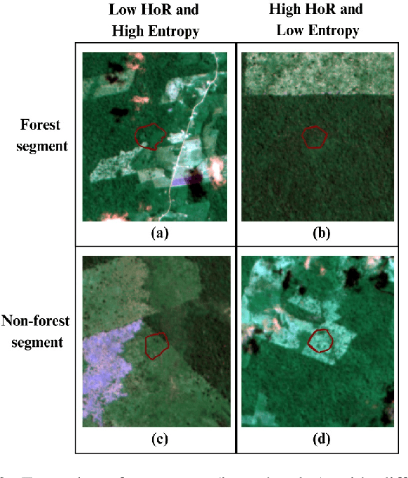
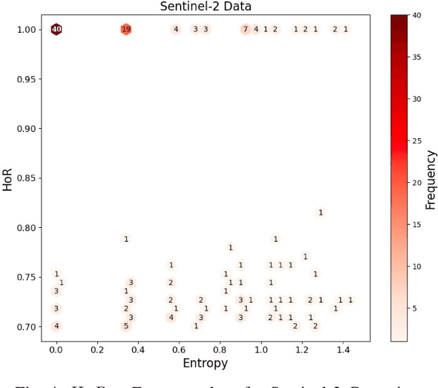
Conserving tropical forests is highly relevant socially and ecologically because of their critical role in the global ecosystem. However, the ongoing deforestation and degradation affect millions of hectares each year, necessitating government or private initiatives to ensure effective forest monitoring. In April 2019, a project based on Citizen Science and Machine Learning models called ForestEyes (FE) was launched with the aim of providing supplementary data to assist experts from government and non-profit organizations in their deforestation monitoring efforts. Recent research has shown that labeling FE project volunteers/citizen scientists helps tailor machine learning models. In this sense, we adopt the FE project to create different sampling strategies based on the wisdom of crowds to select the most suitable samples from the training set to learn an SVM technique and obtain better classification results in deforestation detection tasks. In our experiments, we can show that our strategy based on user entropy-increasing achieved the best classification results in the deforestation detection task when compared with the random sampling strategies, as well as, reducing the convergence time of the SVM technique.
A Framework of Landsat-8 Band Selection based on UMDA for Deforestation Detection
Nov 17, 2023The conservation of tropical forests is a current subject of social and ecological relevance due to their crucial role in the global ecosystem. Unfortunately, millions of hectares are deforested and degraded each year. Therefore, government or private initiatives are needed for monitoring tropical forests. In this sense, this work proposes a novel framework, which uses of distribution estimation algorithm (UMDA) to select spectral bands from Landsat-8 that yield a better representation of deforestation areas to guide a semantic segmentation architecture called DeepLabv3+. In performed experiments, it was possible to find several compositions that reach balanced accuracy superior to 90% in segment classification tasks. Furthermore, the best composition (651) found by UMDA algorithm fed the DeepLabv3+ architecture and surpassed in efficiency and effectiveness all compositions compared in this work.