Carlo de Franchis
Automatic Stockpile Volume Monitoring using Multi-view Stereo from SkySat Imagery
Mar 01, 2021


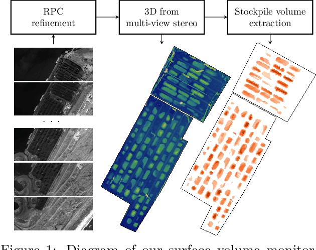
Abstract:This paper proposes a system for automatic surface volume monitoring from time series of SkySat pushframe imagery. A specific challenge of building and comparing large 3D models from SkySat data is to correct inconsistencies between the camera models associated to the multiple views that are necessary to cover the area at a given time, where these camera models are represented as Rational Polynomial Cameras (RPCs). We address the problem by proposing a date-wise RPC refinement, able to handle dynamic areas covered by sets of partially overlapping views. The cameras are refined by means of a rotation that compensates for errors due to inaccurate knowledge of the satellite attitude. The refined RPCs are then used to reconstruct multiple consistent Digital Surface Models (DSMs) from different stereo pairs at each date. RPC refinement strengthens the consistency between the DSMs of each date, which is extremely beneficial to accurately measure volumes in the 3D surface models. The system is tested in a real case scenario, to monitor large coal stockpiles. Our volume estimates are validated with measurements collected on site in the same period of time.
Robust Rational Polynomial Camera Modelling for SAR and Pushbroom Imaging
Feb 26, 2021


Abstract:The Rational Polynomial Camera (RPC) model can be used to describe a variety of image acquisition systems in remote sensing, notably optical and Synthetic Aperture Radar (SAR) sensors. RPC functions relate 3D to 2D coordinates and vice versa, regardless of physical sensor specificities, which has made them an essential tool to harness satellite images in a generic way. This article describes a terrain-independent algorithm to accurately derive a RPC model from a set of 3D-2D point correspondences based on a regularized least squares fit. The performance of the method is assessed by varying the point correspondences and the size of the area that they cover. We test the algorithm on SAR and optical data, to derive RPCs from physical sensor models or from other RPC models after composition with corrective functions.
Assessing the Sharpness of Satellite Images: Study of the PlanetScope Constellation
Apr 19, 2019


Abstract:New micro-satellite constellations enable unprecedented systematic monitoring applications thanks to their wide coverage and short revisit capabilities. However, the large volumes of images that they produce have uneven qualities, creating the need for automatic quality assessment methods. In this work, we quantify the sharpness of images from the PlanetScope constellation by estimating the blur kernel from each image. Once the kernel has been estimated, it is possible to compute an absolute measure of sharpness which allows to discard low quality images and deconvolve blurry images before any further processing. The method is fully blind and automatic, and since it does not require the knowledge of any satellite specifications it can be ported to other constellations.
 Add to Chrome
 Add to Firefox
 Add to Edge