Buo-Fu Chen
Climate Trends of Tropical Cyclone Intensity and Energy Extremes Revealed by Deep Learning
Feb 01, 2024Abstract:Anthropogenic influences have been linked to tropical cyclone (TC) poleward migration, TC extreme precipitation, and an increased proportion of major hurricanes [1, 2, 3, 4]. Understanding past TC trends and variability is critical for projecting future TC impacts on human society considering the changing climate [5]. However, past trends of TC structure/energy remain uncertain due to limited observations; subjective-analyzed and spatiotemporal-heterogeneous "best-track" datasets lead to reduced confidence in the assessed TC repose to climate change [6, 7]. Here, we use deep learning to reconstruct past "observations" and yield an objective global TC wind profile dataset during 1981 to 2020, facilitating a comprehensive examination of TC structure/energy. By training with uniquely labeled data integrating best tracks and numerical model analysis of 2004 to 2018 TCs, our model converts multichannel satellite imagery to a 0-750-km wind profile of axisymmetric surface winds. The model performance is verified to be sufficient for climate studies by comparing it to independent satellite-radar surface winds. Based on the new homogenized dataset, the major TC proportion has increased by ~13% in the past four decades. Moreover, the proportion of extremely high-energy TCs has increased by ~25%, along with an increasing trend (> one standard deviation of the 40-y variability) of the mean total energy of high-energy TCs. Although the warming ocean favors TC intensification, the TC track migration to higher latitudes and altered environments further affect TC structure/energy. This new deep learning method/dataset reveals novel trends regarding TC structure extremes and may help verify simulations/studies regarding TCs in the changing climate.
Accurate and Clear Precipitation Nowcasting with Consecutive Attention and Rain-map Discrimination
Feb 16, 2021
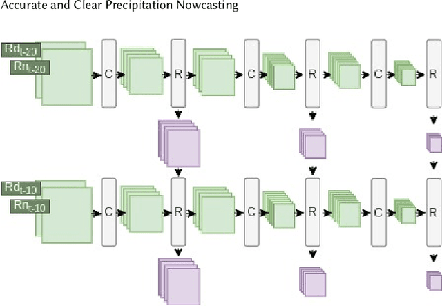
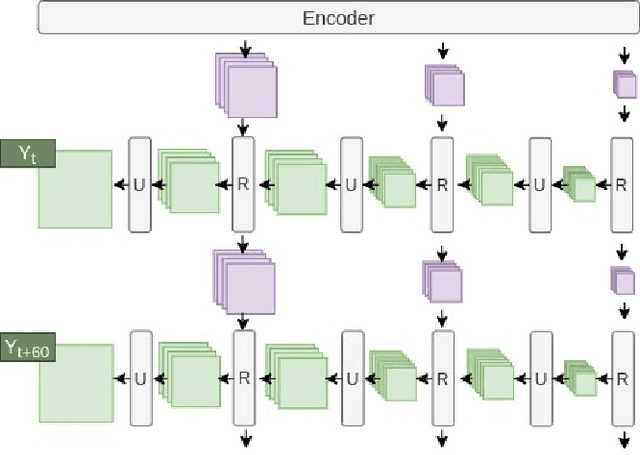
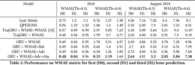
Abstract:Precipitation nowcasting is an important task for weather forecasting. Many recent works aim to predict the high rainfall events more accurately with the help of deep learning techniques, but such events are relatively rare. The rarity is often addressed by formulations that re-weight the rare events. Somehow such a formulation carries a side effect of making "blurry" predictions in low rainfall regions and cannot convince meteorologists to trust its practical usability. We fix the trust issue by introducing a discriminator that encourages the prediction model to generate realistic rain-maps without sacrificing predictive accuracy. Furthermore, we extend the nowcasting time frame from one hour to three hours to further address the needs from meteorologists. The extension is based on consecutive attentions across different hours. We propose a new deep learning model for precipitation nowcasting that includes both the discrimination and attention techniques. The model is examined on a newly-built benchmark dataset that contains both radar data and actual rain data. The benchmark, which will be publicly released, not only establishes the superiority of the proposed model, but also is expected to encourage future research on precipitation nowcasting.
CNN Profiler on Polar Coordinate Images for Tropical Cyclone Structure Analysis
Oct 28, 2020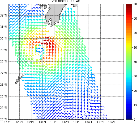
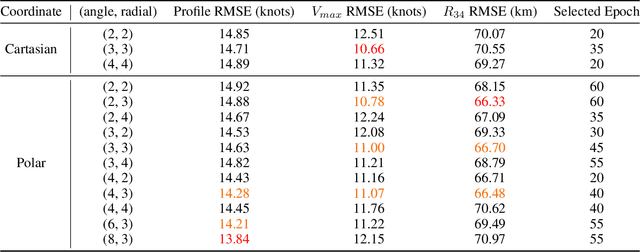
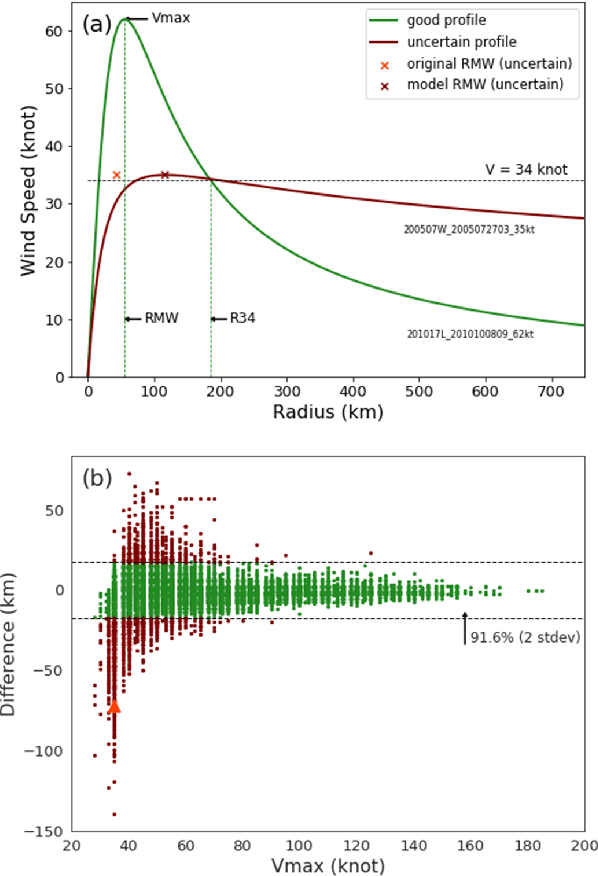

Abstract:Convolutional neural networks (CNN) have achieved great success in analyzing tropical cyclones (TC) with satellite images in several tasks, such as TC intensity estimation. In contrast, TC structure, which is conventionally described by a few parameters estimated subjectively by meteorology specialists, is still hard to be profiled objectively and routinely. This study applies CNN on satellite images to create the entire TC structure profiles, covering all the structural parameters. By utilizing the meteorological domain knowledge to construct TC wind profiles based on historical structure parameters, we provide valuable labels for training in our newly released benchmark dataset. With such a dataset, we hope to attract more attention to this crucial issue among data scientists. Meanwhile, a baseline is established with a specialized convolutional model operating on polar-coordinates. We discovered that it is more feasible and physically reasonable to extract structural information on polar-coordinates, instead of Cartesian coordinates, according to a TC's rotational and spiral natures. Experimental results on the released benchmark dataset verified the robustness of the proposed model and demonstrated the potential for applying deep learning techniques for this barely developed yet important topic.
Real-time Tropical Cyclone Intensity Estimation by Handling Temporally Heterogeneous Satellite Data
Oct 28, 2020


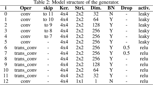
Abstract:Analyzing big geophysical observational data collected by multiple advanced sensors on various satellite platforms promotes our understanding of the geophysical system. For instance, convolutional neural networks (CNN) have achieved great success in estimating tropical cyclone (TC) intensity based on satellite data with fixed temporal frequency (e.g., 3 h). However, to achieve more timely (under 30 min) and accurate TC intensity estimates, a deep learning model is demanded to handle temporally-heterogeneous satellite observations. Specifically, infrared (IR1) and water vapor (WV) images are available under every 15 minutes, while passive microwave rain rate (PMW) is available for about every 3 hours. Meanwhile, the visible (VIS) channel is severely affected by noise and sunlight intensity, making it difficult to be utilized. Therefore, we propose a novel framework that combines generative adversarial network (GAN) with CNN. The model utilizes all data, including VIS and PMW information, during the training phase and eventually uses only the high-frequent IR1 and WV data for providing intensity estimates during the predicting phase. Experimental results demonstrate that the hybrid GAN-CNN framework achieves comparable precision to the state-of-the-art models, while possessing the capability of increasing the maximum estimation frequency from 3 hours to less than 15 minutes.
Attention-based Deep Tropical Cyclone Rapid Intensification Prediction
Sep 25, 2019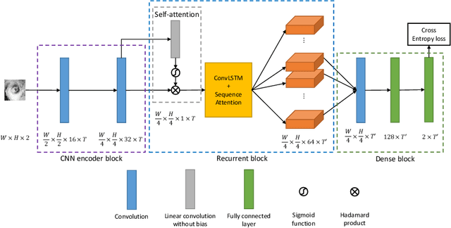

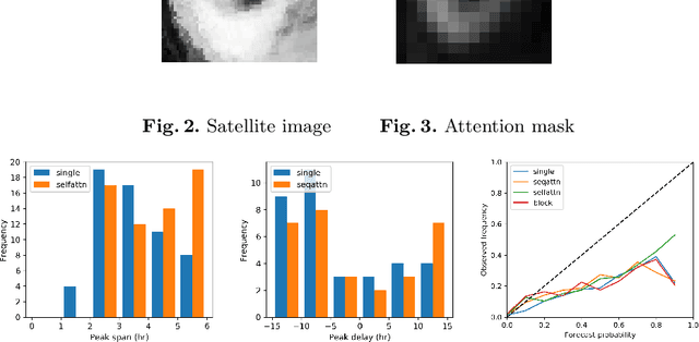
Abstract:Rapid intensification (RI) is when a sudden and considerable increase in tropical cyclone (TC) intensity occurs. Accurate early prediction of RI from TC images is important for preventing the possible damages caused by TCs. The main difficulty of RI prediction is to extract important features that are effective for RI prediction, which is challenging even for experienced meteorologists. Inspired by the success of deep learning models for automatic feature extraction and strong predictive performance, we initiate this study that experiments with multiple domain-knowledge guided deep learning models. The goal is to evaluate the potential use of these models for RI prediction. Furthermore, we examine the internal states of the models to obtain visualizable insights for RI prediction. Our model is efficient in training while achieving state-of-the-art performance on the benchmark dataset on HSS metric. The results showcase the success of adapting deep learning to solve complex meteorology problems.
 Add to Chrome
 Add to Firefox
 Add to Edge