 Add to Chrome
 Add to Firefox
 Add to Edge
Dark Energy Survey Year 3 results: Simulation-based $w$CDM inference from weak lensing and galaxy clustering maps with deep learning. I. Analysis design
Nov 06, 2025Data-driven approaches using deep learning are emerging as powerful techniques to extract non-Gaussian information from cosmological large-scale structure. This work presents the first simulation-based inference (SBI) pipeline that combines weak lensing and galaxy clustering maps in a realistic Dark Energy Survey Year 3 (DES Y3) configuration and serves as preparation for a forthcoming analysis of the survey data. We develop a scalable forward model based on the CosmoGridV1 suite of N-body simulations to generate over one million self-consistent mock realizations of DES Y3 at the map level. Leveraging this large dataset, we train deep graph convolutional neural networks on the full survey footprint in spherical geometry to learn low-dimensional features that approximately maximize mutual information with target parameters. These learned compressions enable neural density estimation of the implicit likelihood via normalizing flows in a ten-dimensional parameter space spanning cosmological $w$CDM, intrinsic alignment, and linear galaxy bias parameters, while marginalizing over baryonic, photometric redshift, and shear bias nuisances. To ensure robustness, we extensively validate our inference pipeline using synthetic observations derived from both systematic contaminations in our forward model and independent Buzzard galaxy catalogs. Our forecasts yield significant improvements in cosmological parameter constraints, achieving $2-3\times$ higher figures of merit in the $\Omega_m - S_8$ plane relative to our implementation of baseline two-point statistics and effectively breaking parameter degeneracies through probe combination. These results demonstrate the potential of SBI analyses powered by deep learning for upcoming Stage-IV wide-field imaging surveys.
S$^{2}$OMGAN: Shortcut from Remote Sensing Images to Online Maps
Jan 21, 2020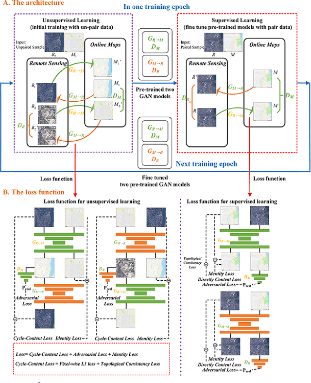
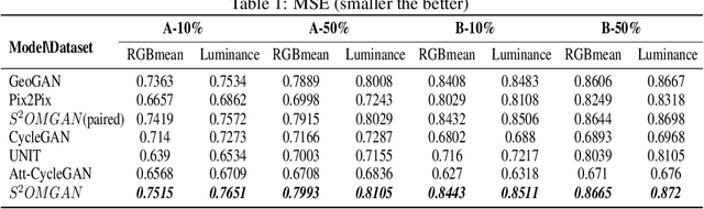
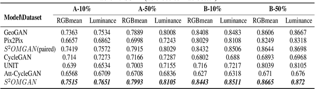
Traditional online maps, widely used on Internet such as Google map and Baidu map, are rendered from vector data. Timely updating online maps from vector data, of which the generating is time-consuming, is a difficult mission. It is a shortcut to generate online maps in time from remote sensing images, which can be acquired timely without vector data. However, this mission used to be challenging or even impossible. Inspired by image-to-image translation (img2img) techniques based on generative adversarial network (GAN), we propose a semi-supervised structure-augmented online map GAN (S$^{2}$OMGAN) model to generate online maps directly from remote sensing images. In this model, we designed a semi-supervised learning strategy to pre-train S$^{2}$OMGAN on rich unpaired samples and finetune it on limited paired samples in reality. We also designed image gradient L1 loss and image gradient structure loss to generate an online map with global topological relationship and detailed edge curves of objects, which are important in cartography. Moreover, we propose edge structural similarity index (ESSI) as a metric to evaluate the quality of topological consistency between generated online maps and ground truths. Experimental results present that S$^{2}$OMGAN outperforms state-of-the-art (SOTA) works according to mean squared error, structural similarity index and ESSI. Also, S$^{2}$OMGAN wins more approval than SOTA in the human perceptual test on visual realism of cartography. Our work shows that S$^{2}$OMGAN is potentially a new paradigm to produce online maps. Our implementation of the S$^{2}$OMGAN is available at \url{https://github.com/imcsq/S2OMGAN}.