Arpan Man Sainju
Deep Learning for Earth Image Segmentation based on Imperfect Polyline Labels with Annotation Errors
Oct 02, 2020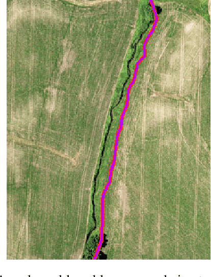


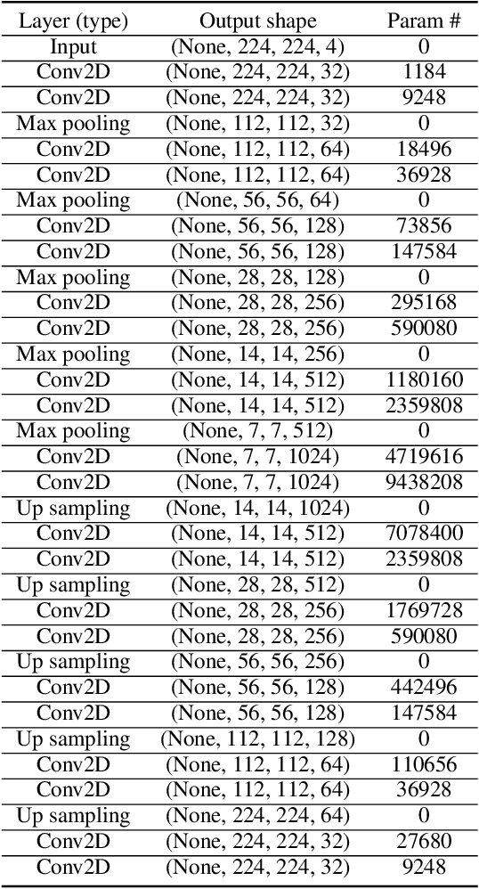
Abstract:In recent years, deep learning techniques (e.g., U-Net, DeepLab) have achieved tremendous success in image segmentation. The performance of these models heavily relies on high-quality ground truth segment labels. Unfortunately, in many real-world problems, ground truth segment labels often have geometric annotation errors due to manual annotation mistakes, GPS errors, or visually interpreting background imagery at a coarse resolution. Such location errors will significantly impact the training performance of existing deep learning algorithms. Existing research on label errors either models ground truth errors in label semantics (assuming label locations to be correct) or models label location errors with simple square patch shifting. These methods cannot fully incorporate the geometric properties of label location errors. To fill the gap, this paper proposes a generic learning framework based on the EM algorithm to update deep learning model parameters and infer hidden true label locations simultaneously. Evaluations on a real-world hydrological dataset in the streamline refinement application show that the proposed framework outperforms baseline methods in classification accuracy (reducing the number of false positives by 67% and reducing the number of false negatives by 55%).
Deep Neural Network for 3D Surface Segmentation based on Contour Tree Hierarchy
Aug 25, 2020
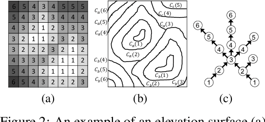
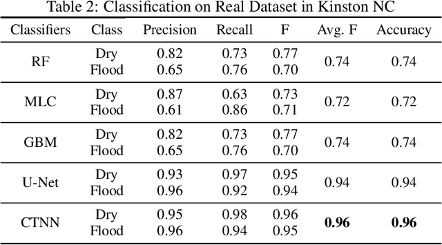
Abstract:Given a 3D surface defined by an elevation function on a 2D grid as well as non-spatial features observed at each pixel, the problem of surface segmentation aims to classify pixels into contiguous classes based on both non-spatial features and surface topology. The problem has important applications in hydrology, planetary science, and biochemistry but is uniquely challenging for several reasons. First, the spatial extent of class segments follows surface contours in the topological space, regardless of their spatial shapes and directions. Second, the topological structure exists in multiple spatial scales based on different surface resolutions. Existing widely successful deep learning models for image segmentation are often not applicable due to their reliance on convolution and pooling operations to learn regular structural patterns on a grid. In contrast, we propose to represent surface topological structure by a contour tree skeleton, which is a polytree capturing the evolution of surface contours at different elevation levels. We further design a graph neural network based on the contour tree hierarchy to model surface topological structure at different spatial scales. Experimental evaluations based on real-world hydrological datasets show that our model outperforms several baseline methods in classification accuracy.
Spatial Classification With Limited Observations Based On Physics-Aware Structural Constraint
Aug 25, 2020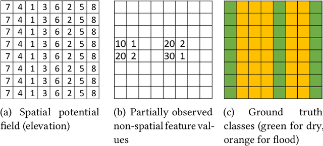

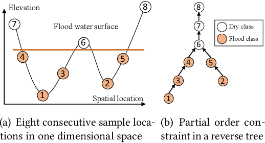

Abstract:Spatial classification with limited feature observations has been a challenging problem in machine learning. The problem exists in applications where only a subset of sensors are deployed at certain spots or partial responses are collected in field surveys. Existing research mostly focuses on addressing incomplete or missing data, e.g., data cleaning and imputation, classification models that allow for missing feature values or model missing features as hidden variables in the EM algorithm. These methods, however, assume that incomplete feature observations only happen on a small subset of samples, and thus cannot solve problems where the vast majority of samples have missing feature observations. To address this issue, we recently proposed a new approach that incorporates physics-aware structural constraint into the model representation. Our approach assumes that a spatial contextual feature is observed for all sample locations and establishes spatial structural constraint from the underlying spatial contextual feature map. We design efficient algorithms for model parameter learning and class inference. This paper extends our recent approach by allowing feature values of samples in each class to follow a multi-modal distribution. We propose learning algorithms for the extended model with multi-modal distribution. Evaluations on real-world hydrological applications show that our approach significantly outperforms baseline methods in classification accuracy, and the multi-modal extension is more robust than our early single-modal version especially when feature distribution in training samples is multi-modal. Computational experiments show that the proposed solution is computationally efficient on large datasets.
A Hidden Markov Tree Model for Flood Extent Mapping in Heavily Vegetated Areas based on High Resolution Aerial Imagery and DEM: A Case Study on Hurricane Matthew Floods
Aug 25, 2020


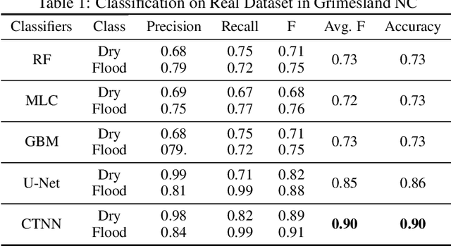
Abstract:Flood extent mapping plays a crucial role in disaster management and national water forecasting. In recent years, high-resolution optical imagery becomes increasingly available with the deployment of numerous small satellites and drones. However, analyzing such imagery data to extract flood extent poses unique challenges due to the rich noise and shadows, obstacles (e.g., tree canopies, clouds), and spectral confusion between pixel classes (flood, dry) due to spatial heterogeneity. Existing machine learning techniques often focus on spectral and spatial features from raster images without fully incorporating the geographic terrain within classification models. In contrast, we recently proposed a novel machine learning model called geographical hidden Markov tree that integrates spectral features of pixels and topographic constraints from Digital Elevation Model (DEM) data (i.e., water flow directions) in a holistic manner. This paper evaluates the model through case studies on high-resolution aerial imagery from the National Oceanic and Atmospheric Administration (NOAA) National Geodetic Survey together with DEM. Three scenes are selected in heavily vegetated floodplains near the cities of Grimesland and Kinston in North Carolina during Hurricane Matthew floods in 2016. Results show that the proposed hidden Markov tree model outperforms several state of the art machine learning algorithms (e.g., random forests, gradient boosted model) by an improvement of F-score (the harmonic mean of the user's accuracy and producer's accuracy) from around 70% to 80% to over 95% on our datasets.
Geographical Hidden Markov Tree for Flood Extent Mapping (With Proof Appendix)
May 24, 2018


Abstract:Flood extent mapping plays a crucial role in disaster management and national water forecasting. Unfortunately, traditional classification methods are often hampered by the existence of noise, obstacles and heterogeneity in spectral features as well as implicit anisotropic spatial dependency across class labels. In this paper, we propose geographical hidden Markov tree, a probabilistic graphical model that generalizes the common hidden Markov model from a one dimensional sequence to a two dimensional map. Anisotropic spatial dependency is incorporated in the hidden class layer with a reverse tree structure. We also investigate computational algorithms for reverse tree construction, model parameter learning and class inference. Extensive evaluations on both synthetic and real world datasets show that proposed model outperforms multiple baselines in flood mapping, and our algorithms are scalable on large data sizes.
 Add to Chrome
 Add to Firefox
 Add to Edge