Alexander Y. Sun
Rapid Flood Inundation Forecast Using Fourier Neural Operator
Jul 29, 2023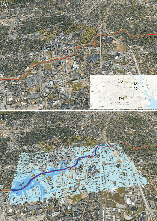
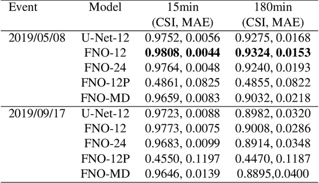

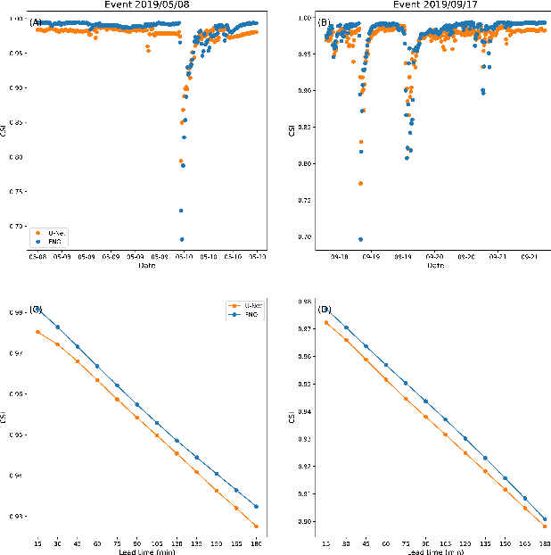
Abstract:Flood inundation forecast provides critical information for emergency planning before and during flood events. Real time flood inundation forecast tools are still lacking. High-resolution hydrodynamic modeling has become more accessible in recent years, however, predicting flood extents at the street and building levels in real-time is still computationally demanding. Here we present a hybrid process-based and data-driven machine learning (ML) approach for flood extent and inundation depth prediction. We used the Fourier neural operator (FNO), a highly efficient ML method, for surrogate modeling. The FNO model is demonstrated over an urban area in Houston (Texas, U.S.) by training using simulated water depths (in 15-min intervals) from six historical storm events and then tested over two holdout events. Results show FNO outperforms the baseline U-Net model. It maintains high predictability at all lead times tested (up to 3 hrs) and performs well when applying to new sites, suggesting strong generalization skill.
Applications of physics-informed scientific machine learning in subsurface science: A survey
Apr 13, 2021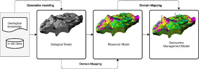
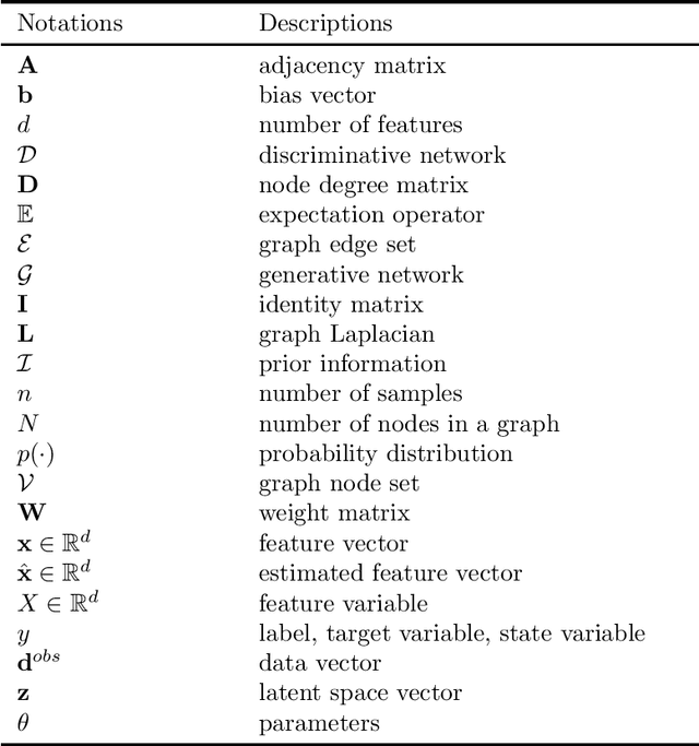
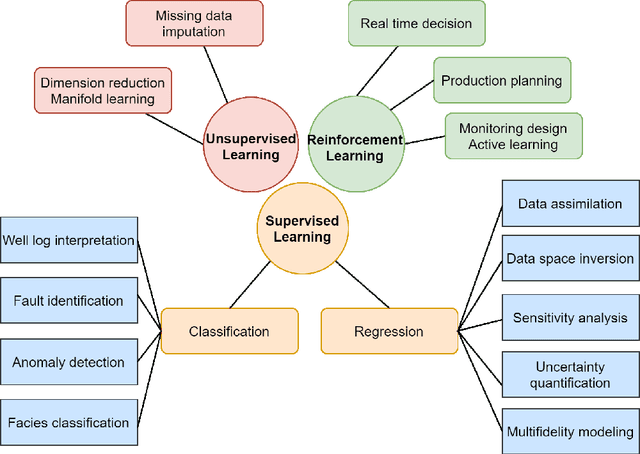
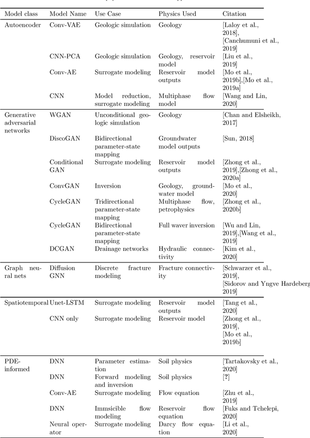
Abstract:Geosystems are geological formations altered by humans activities such as fossil energy exploration, waste disposal, geologic carbon sequestration, and renewable energy generation. Geosystems also represent a critical link in the global water-energy nexus, providing both the source and buffering mechanisms for enabling societal adaptation to climate variability and change. The responsible use and exploration of geosystems are thus critical to the geosystem governance, which in turn depends on the efficient monitoring, risk assessment, and decision support tools for practical implementation. Fast advances in machine learning (ML) algorithms and novel sensing technologies in recent years have presented new opportunities for the subsurface research community to improve the efficacy and transparency of geosystem governance. Although recent studies have shown the great promise of scientific ML (SciML) models, questions remain on how to best leverage ML in the management of geosystems, which are typified by multiscality, high-dimensionality, and data resolution inhomogeneity. This survey will provide a systematic review of the recent development and applications of domain-aware SciML in geosystem researches, with an emphasis on how the accuracy, interpretability, scalability, defensibility, and generalization skill of ML approaches can be improved to better serve the geoscientific community.
Combining Physically-Based Modeling and Deep Learning for Fusing GRACE Satellite Data: Can We Learn from Mismatch?
Jan 31, 2019

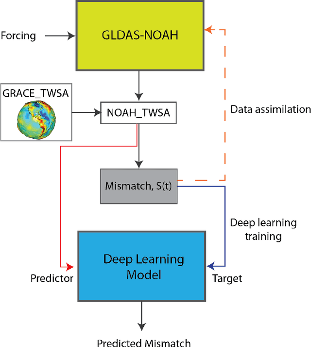
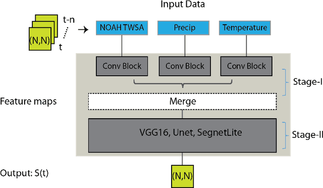
Abstract:Global hydrological and land surface models are increasingly used for tracking terrestrial total water storage (TWS) dynamics, but the utility of existing models is hampered by conceptual and/or data uncertainties related to various underrepresented and unrepresented processes, such as groundwater storage. The gravity recovery and climate experiment (GRACE) satellite mission provided a valuable independent data source for tracking TWS at regional and continental scales. Strong interests exist in fusing GRACE data into global hydrological models to improve their predictive performance. Here we develop and apply deep convolutional neural network (CNN) models to learn the spatiotemporal patterns of mismatch between TWS anomalies (TWSA) derived from GRACE and those simulated by NOAH, a widely used land surface model. Once trained, our CNN models can be used to correct the NOAH simulated TWSA without requiring GRACE data, potentially filling the data gap between GRACE and its follow-on mission, GRACE-FO. Our methodology is demonstrated over India, which has experienced significant groundwater depletion in recent decades that is nevertheless not being captured by the NOAH model. Results show that the CNN models significantly improve the match with GRACE TWSA, achieving a country-average correlation coefficient of 0.94 and Nash-Sutcliff efficient of 0.87, or 14\% and 52\% improvement respectively over the original NOAH TWSA. At the local scale, the learned mismatch pattern correlates well with the observed in situ groundwater storage anomaly data for most parts of India, suggesting that deep learning models effectively compensate for the missing groundwater component in NOAH for this study region.
Discovering state-parameter mappings in subsurface models using generative adversarial networks
Oct 30, 2018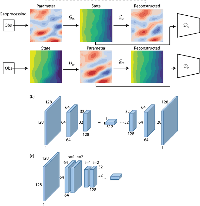
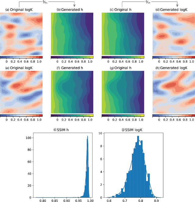
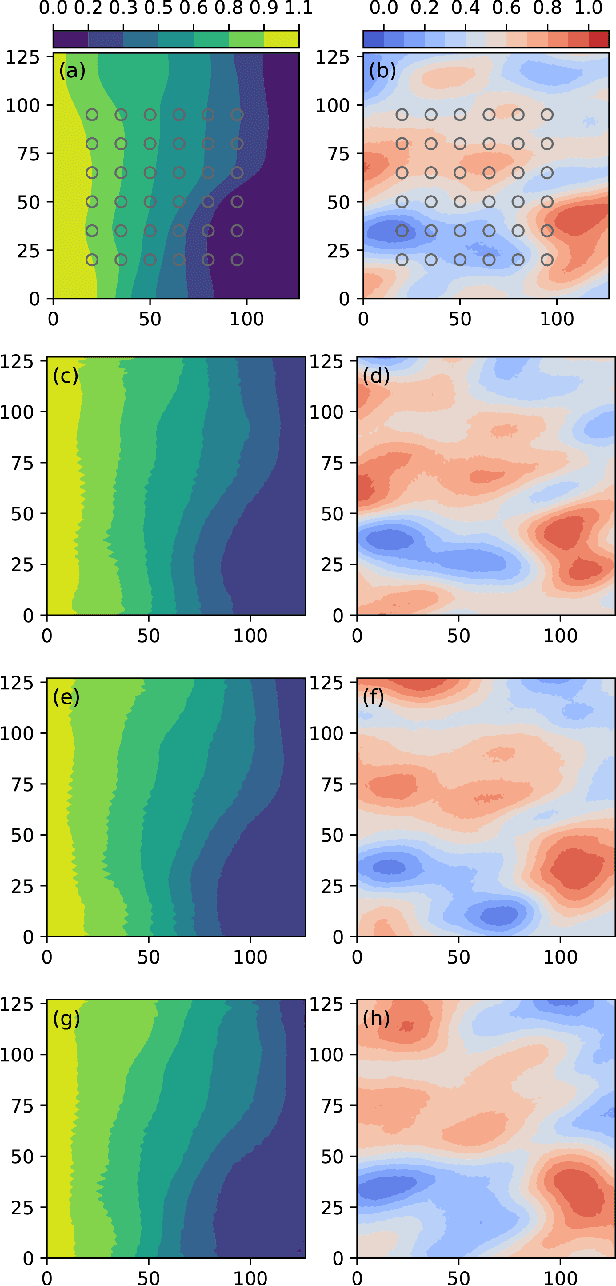
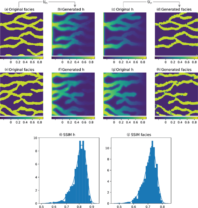
Abstract:A fundamental problem in geophysical modeling is related to the identification and approximation of causal structures among physical processes. However, resolving the bidirectional mappings between physical parameters and model state variables (i.e., solving the forward and inverse problems) is challenging, especially when parameter dimensionality is high. Deep learning has opened a new door toward knowledge representation and complex pattern identification. In particular, the recently introduced generative adversarial networks (GANs) hold strong promises in learning cross-domain mappings for image translation. This study presents a state-parameter identification GAN (SPID-GAN) for simultaneously learning bidirectional mappings between a high-dimensional parameter space and the corresponding model state space. SPID-GAN is demonstrated using a series of representative problems from subsurface flow modeling. Results show that SPID-GAN achieves satisfactory performance in identifying the bidirectional state-parameter mappings, providing a new deep-learning-based, knowledge representation paradigm for a wide array of complex geophysical problems.
 Add to Chrome
 Add to Firefox
 Add to Edge