U2UData: A Large-scale Cooperative Perception Dataset for Swarm UAVs Autonomous Flight
Paper and Code
Aug 05, 2024


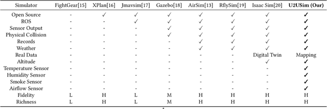
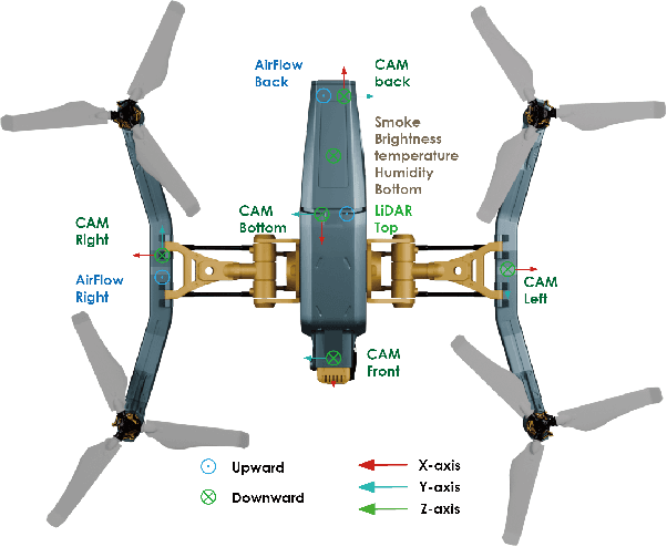
Modern perception systems for autonomous flight are sensitive to occlusion and have limited long-range capability, which is a key bottleneck in improving low-altitude economic task performance. Recent research has shown that the UAV-to-UAV (U2U) cooperative perception system has great potential to revolutionize the autonomous flight industry. However, the lack of a large-scale dataset is hindering progress in this area. This paper presents U2UData, the first large-scale cooperative perception dataset for swarm UAVs autonomous flight. The dataset was collected by three UAVs flying autonomously in the U2USim, covering a 9 km$^2$ flight area. It comprises 315K LiDAR frames, 945K RGB and depth frames, and 2.41M annotated 3D bounding boxes for 3 classes. It also includes brightness, temperature, humidity, smoke, and airflow values covering all flight routes. U2USim is the first real-world mapping swarm UAVs simulation environment. It takes Yunnan Province as the prototype and includes 4 terrains, 7 weather conditions, and 8 sensor types. U2UData introduces two perception tasks: cooperative 3D object detection and cooperative 3D object tracking. This paper provides comprehensive benchmarks of recent cooperative perception algorithms on these tasks.
 Add to Chrome
 Add to Firefox
 Add to Edge