SaNet: Scale-aware Neural Network for Semantic Labelling of Multiple Spatial Resolution Aerial Images
Paper and Code
Apr 10, 2021


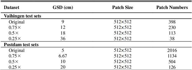
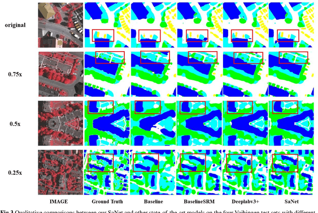
Assigning geospatial objects of aerial images with specific categories at the pixel level is a fundamental task in urban scene interpretation. Along with rapid developments in sensor technologies, aerial images can be captured at multiple spatial resolutions (MSR) with information content manifested at different scales. Extracting information from these MSR aerial images represents huge opportunities for enhanced feature representation and characterisation. However, MSR images suffer from two critical issues: 1) increased variation in the sizes of geospatial objects and 2) information and informative feature loss at coarse spatial resolutions. In this paper, we propose a novel scale-aware neural network (SaNet) for semantic labelling of MSR aerial images to address these two issues. SaNet deploys a densely connected feature network (DCFPN) module to capture high-quality multi-scale context, such as to address the scale variation issue and increase the quality of segmentation for both large and small objects simultaneously. A spatial feature recalibration (SFR) module is further incorporated into the network to learn complete semantic features with enhanced spatial relationships, where the effects of information and informative feature loss are addressed. The combination of DCFPN and SFR allows the proposed SaNet to learn scale-aware features from MSR aerial images. Extensive experiments undertaken on ISPRS semantic segmentation datasets demonstrated the outstanding accuracy of the proposed SaNet in cross-resolution segmentation, with an average OA of 83.4% on the Vaihingen dataset and an average F1 score of 80.4% on the Potsdam dataset, outperforming state-of-the-art deep learning approaches, including FPN (80.2% and 76.6%), PSPNet (79.8% and 76.2%) and Deeplabv3+ (80.8% and 76.1%) as well as DDCM-Net (81.7% and 77.6%) and EaNet (81.5% and 78.3%).
 Add to Chrome
 Add to Firefox
 Add to Edge