Yuuki Nishiyama
Poster: Recognizing Hidden-in-the-Ear Private Key for Reliable Silent Speech Interface Using Multi-Task Learning
Dec 18, 2025Abstract:Silent speech interface (SSI) enables hands-free input without audible vocalization, but most SSI systems do not verify speaker identity. We present HEar-ID, which uses consumer active noise-canceling earbuds to capture low-frequency "whisper" audio and high-frequency ultrasonic reflections. Features from both streams pass through a shared encoder, producing embeddings that feed a contrastive branch for user authentication and an SSI head for silent spelling recognition. This design supports decoding of 50 words while reliably rejecting impostors, all on commodity earbuds with a single model. Experiments demonstrate that HEar-ID achieves strong spelling accuracy and robust authentication.
Image Generative Semantic Communication with Multi-Modal Similarity Estimation for Resource-Limited Networks
Apr 17, 2024Abstract:To reduce network traffic and support environments with limited resources, a method for transmitting images with low amounts of transmission data is required. Machine learning-based image compression methods, which compress the data size of images while maintaining their features, have been proposed. However, in certain situations, reconstructing a part of semantic information of images at the receiver end may be sufficient. To realize this concept, semantic-information-based communication, called semantic communication, has been proposed, along with an image transmission method using semantic communication. This method transmits only the semantic information of an image, and the receiver reconstructs the image using an image-generation model. This method utilizes one type of semantic information, but reconstructing images similar to the original image using only it is challenging. This study proposes a multi-modal image transmission method that leverages diverse semantic information for efficient semantic communication. The proposed method extracts multi-modal semantic information from an image and transmits only it. Subsequently, the receiver generates multiple images using an image-generation model and selects an output based on semantic similarity. The receiver must select the output based only on the received features; however, evaluating semantic similarity using conventional metrics is challenging. Therefore, this study explored new metrics to evaluate the similarity between semantic features of images and proposes two scoring procedures. The results indicate that the proposed procedures can compare semantic similarities, such as position and composition, between semantic features of the original and generated images. Thus, the proposed method can facilitate the transmission and utilization of photographs through mobile networks for various service applications.
Convergence Visualizer of Decentralized Federated Distillation with Reduced Communication Costs
Dec 19, 2023Abstract:Federated learning (FL) achieves collaborative learning without the need for data sharing, thus preventing privacy leakage. To extend FL into a fully decentralized algorithm, researchers have applied distributed optimization algorithms to FL by considering machine learning (ML) tasks as parameter optimization problems. Conversely, the consensus-based multi-hop federated distillation (CMFD) proposed in the authors' previous work makes neural network (NN) models get close with others in a function space rather than in a parameter space. Hence, this study solves two unresolved challenges of CMFD: (1) communication cost reduction and (2) visualization of model convergence. Based on a proposed dynamic communication cost reduction method (DCCR), the amount of data transferred in a network is reduced; however, with a slight degradation in the prediction accuracy. In addition, a technique for visualizing the distance between the NN models in a function space is also proposed. The technique applies a dimensionality reduction technique by approximating infinite-dimensional functions as numerical vectors to visualize the trajectory of how the models change by the distributed learning algorithm.
* (c) 2023 IEEE. Personal use of this material is permitted. Permission from IEEE must be obtained for all other uses, in any current or future media, including reprinting/republishing this material for advertising or promotional purposes, creating new collective works, for resale or redistribution to servers or lists, or reuse of any copyrighted component of this work in other works
Estimating Sunlight Using GNSS Signal Strength from Smartphone
Aug 09, 2022


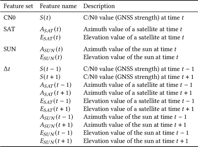
Abstract:Excessive or inadequate exposure to ultraviolet light (UV) is harmful to health and causes osteoporosis, colon cancer, and skin cancer. The UV Index, a standard scale of UV light, tends to increase in sunny places and sharply decrease in the shade. A method for distinguishing shady and sunny places would help us to prevent and cure diseases caused by UV. However, the existing methods, such as carrying UV sensors, impose a load on the user, whereas city-level UV forecasts do not have enough granularity for monitoring an individual's UV exposure. This paper proposes a method to detect sunny and shady places by using an off-the-shelf mobile device. The method detects these places by using a characteristic of the GNSS signal strength that is attenuated by objects around the device. As a dataset, we collected GNSS signal data, such as C/N0, satellite ID, satellite angle, and sun angle, together with reference data (i.e., sunny and shady place information every minute) for four days from five locations. Using the dataset, we created twelve classification models by using supervised machine learning methods and evaluated their performance by 4-fold cross-validation. In addition, we investigated the feature importance and the effect of combining features. The performance evaluation showed that our classification model could classify sunny and shady places with more than 97% accuracy in the best case. Moreover, our investigation revealed that the value of C/N0 at a moment and its time series (i.e., C/N0 value before and after the moment) are more important features.
 Add to Chrome
 Add to Firefox
 Add to Edge