Thomas Hugues
STPLS3D: A Large-Scale Synthetic and Real Aerial Photogrammetry 3D Point Cloud Dataset
Mar 17, 2022


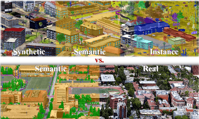
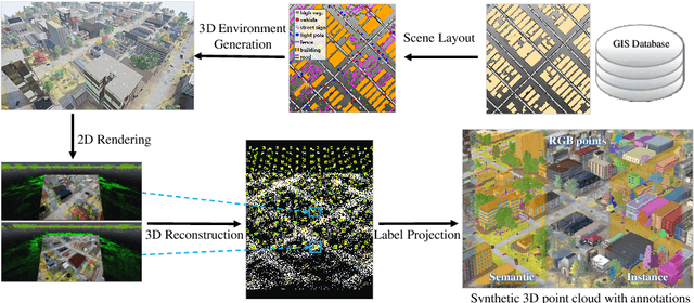
Abstract:Although various 3D datasets with different functions and scales have been proposed recently, it remains challenging for individuals to complete the whole pipeline of large-scale data collection, sanitization, and annotation. Moreover, the created datasets usually suffer from extremely imbalanced class distribution or partial low-quality data samples. Motivated by this, we explore the procedurally synthetic 3D data generation paradigm to equip individuals with the full capability of creating large-scale annotated photogrammetry point clouds. Specifically, we introduce a synthetic aerial photogrammetry point clouds generation pipeline that takes full advantage of open geospatial data sources and off-the-shelf commercial packages. Unlike generating synthetic data in virtual games, where the simulated data usually have limited gaming environments created by artists, the proposed pipeline simulates the reconstruction process of the real environment by following the same UAV flight pattern on different synthetic terrain shapes and building densities, which ensure similar quality, noise pattern, and diversity with real data. In addition, the precise semantic and instance annotations can be generated fully automatically, avoiding the expensive and time-consuming manual annotation. Based on the proposed pipeline, we present a richly-annotated synthetic 3D aerial photogrammetry point cloud dataset, termed STPLS3D, with more than 16 $km^2$ of landscapes and up to 18 fine-grained semantic categories. For verification purposes, we also provide a parallel dataset collected from four areas in the real environment. Extensive experiments conducted on our datasets demonstrate the effectiveness and quality of the proposed synthetic dataset.
 Add to Chrome
 Add to Firefox
 Add to Edge