Tarun Narayanan
Curator: Creating Large-Scale Curated Labelled Datasets using Self-Supervised Learning
Dec 28, 2022


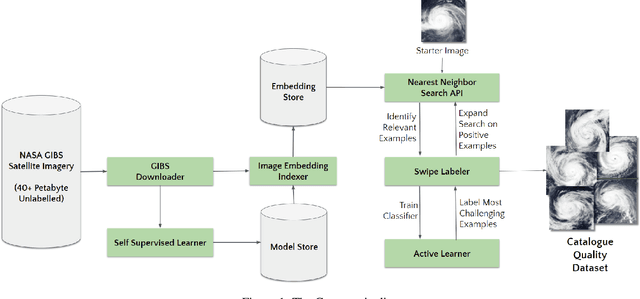
Abstract:Applying Machine learning to domains like Earth Sciences is impeded by the lack of labeled data, despite a large corpus of raw data available in such domains. For instance, training a wildfire classifier on satellite imagery requires curating a massive and diverse dataset, which is an expensive and time-consuming process that can span from weeks to months. Searching for relevant examples in over 40 petabytes of unlabelled data requires researchers to manually hunt for such images, much like finding a needle in a haystack. We present a no-code end-to-end pipeline, Curator, which dramatically minimizes the time taken to curate an exhaustive labeled dataset. Curator is able to search massive amounts of unlabelled data by combining self-supervision, scalable nearest neighbor search, and active learning to learn and differentiate image representations. The pipeline can also be readily applied to solve problems across different domains. Overall, the pipeline makes it practical for researchers to go from just one reference image to a comprehensive dataset in a diminutive span of time.
 Add to Chrome
 Add to Firefox
 Add to Edge