Suhail Al-Dharrab
Ultra-Reliable Device-Centric Uplink Communications in Airborne Networks: A Spatiotemporal Analysis
Feb 26, 2023Abstract:This paper proposes an ultra-reliable device-centric uplink (URDC-UL) communication scheme for airborne networks. In particular, base stations (BSs) are mounted on unmanned aerial vehicles (UAVs) that travel to schedule UL transmissions and collect data from devices. To attain an ultra-reliable unified device-centric performance, the UL connection is established when the UAV-BS is hovering at the nearest possible distance from the scheduled device. The performance of the proposed URDC-UL scheme is benchmarked against a stationary UAV-centric uplink (SUC-UL) scheme where the devices are scheduled to communicate to UAV-BSs that are continuously hovering at static locations. Utilizing stochastic geometry and queueing theory, novel spatiotemporal mathematical models are developed, which account for the UAV-BS spatial densities, mobility, altitude, antenna directivity, ground-to-air channel, and temporal traffic, among other factors. The results demonstrate the sensitivity of the URDC-UL scheme to the ratio between hovering and traveling time. In particular, the hovering to traveling time ratio should be carefully adjusted to maximize the harvested performance gains for the URDC-UL scheme in terms of link reliability, transmission rate, energy efficiency, and delay. Exploiting the URDC-UL scheme allows IoT devices to minimize transmission power while maintaining unified reliable transmission. This preserves the device's battery and addresses a critical IoT design challenge.
Energy-Efficient mm-Wave Backhauling via Frame Aggregation in Wide Area Networks
May 20, 2021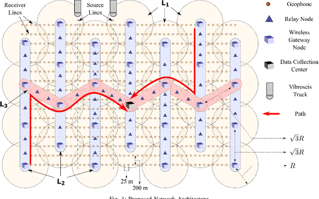
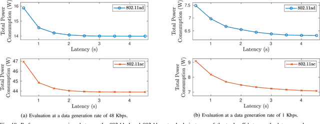
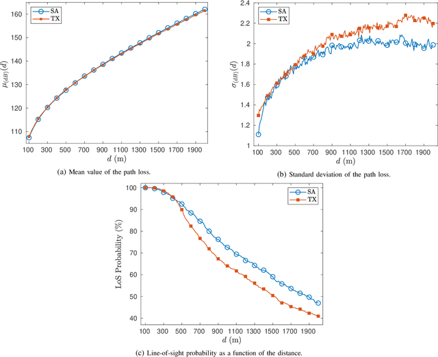
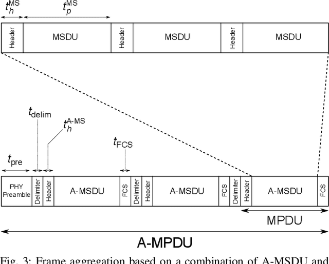
Abstract:Wide area networks for surveying applications, such as seismic acquisition, have been witnessing a significant increase in node density and area, where large amounts of data have to be transferred in real-time. While cables can meet these requirements, they account for a majority of the equipment weight, maintenance, and labor costs. A novel wireless network architecture, compliant with the IEEE 802.11ad standard, is proposed for establishing scalable, energy-efficient, and gigabit-rate backhaul across very large areas. Statistical path-loss and line-of-sight models are derived using real-world topographic data in well-known seismic regions. Additionally, a cross-layer analytical model is derived for 802.11 systems that can characterize the overall latency and power consumption under the impact of co-channel interference. On the basis of these models, a Frame Aggregation Power-Saving Backhaul (FA-PSB) scheme is proposed for near-optimal power conservation under a latency constraint, through a duty-cycled approach. A performance evaluation with respect to the survey size and data generation rate reveals that the proposed architecture and the FA-PSB scheme can support real-time acquisition in large-scale high-density scenarios while operating with minimal power consumption, thereby enhancing the lifetime of wireless seismic surveys. The FA-PSB scheme can be applied to cellular backhaul and sensor networks as well.
A comparative study of texture attributes for characterizing subsurface structures in seismic volumes
Dec 19, 2018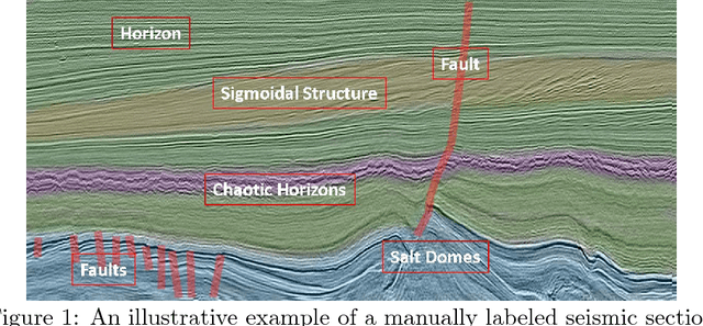
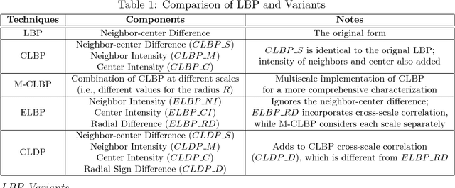
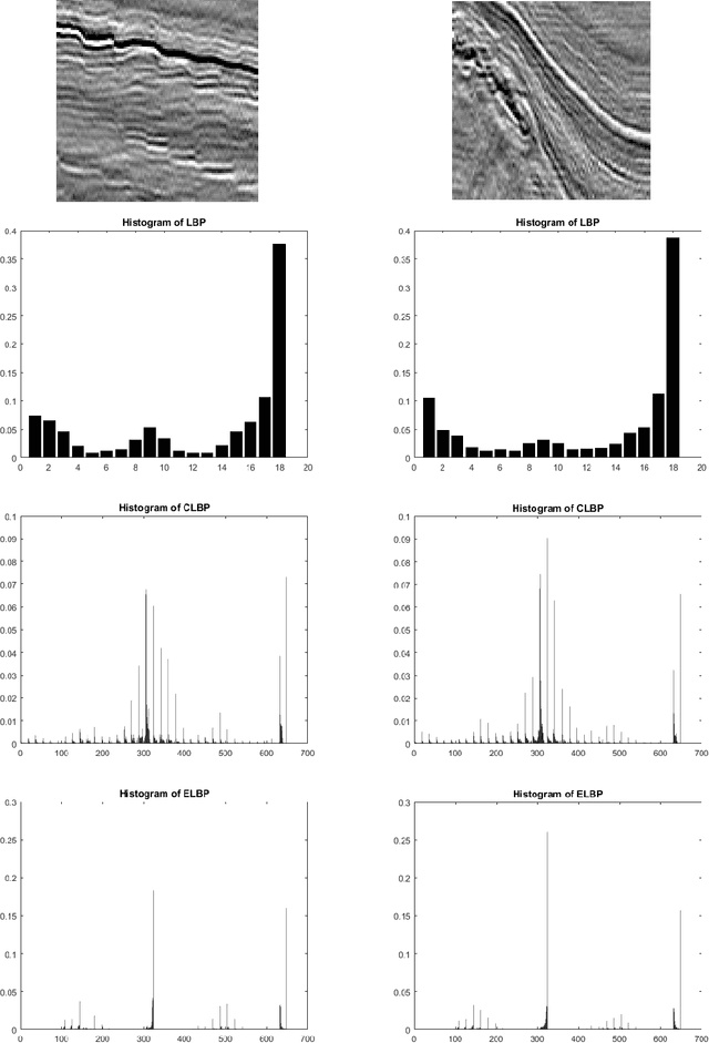

Abstract:In this paper, we explore how to computationally characterize subsurface geological structures presented in seismic volumes using texture attributes. For this purpose, we conduct a comparative study of typical texture attributes presented in the image processing literature. We focus on spatial attributes in this study and examine them in a new application for seismic interpretation, i.e., seismic volume labeling. For this application, a data volume is automatically segmented into various structures, each assigned with its corresponding label. If the labels are assigned with reasonable accuracy, such volume labeling will help initiate an interpretation process in a more effective manner. Our investigation proves the feasibility of accomplishing this task using texture attributes. Through the study, we also identify advantages and disadvantages associated with each attribute.
 Add to Chrome
 Add to Firefox
 Add to Edge