Stefania Di Tommaso
Department of Earth System Science and Center on Food Security and the Environment, Stanford University
Annual field-scale maps of tall and short crops at the global scale using GEDI and Sentinel-2
Dec 19, 2022


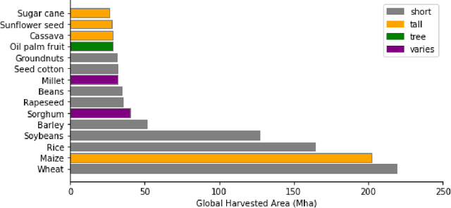
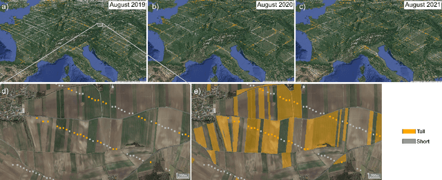
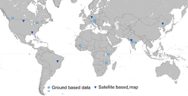
Abstract:Crop type maps are critical for tracking agricultural land use and estimating crop production. Remote sensing has proven an efficient and reliable tool for creating these maps in regions with abundant ground labels for model training, yet these labels remain difficult to obtain in many regions and years. NASA's Global Ecosystem Dynamics Investigation (GEDI) spaceborne lidar instrument, originally designed for forest monitoring, has shown promise for distinguishing tall and short crops. In the current study, we leverage GEDI to develop wall-to-wall maps of short vs tall crops on a global scale at 10 m resolution for 2019-2021. Specifically, we show that (1) GEDI returns can reliably be classified into tall and short crops after removing shots with extreme view angles or topographic slope, (2) the frequency of tall crops over time can be used to identify months when tall crops are at their peak height, and (3) GEDI shots in these months can then be used to train random forest models that use Sentinel-2 time series to accurately predict short vs. tall crops. Independent reference data from around the world are then used to evaluate these GEDI-S2 maps. We find that GEDI-S2 performed nearly as well as models trained on thousands of local reference training points, with accuracies of at least 87% and often above 90% throughout the Americas, Europe, and East Asia. Systematic underestimation of tall crop area was observed in regions where crops frequently exhibit low biomass, namely Africa and South Asia, and further work is needed in these systems. Although the GEDI-S2 approach only differentiates tall from short crops, in many landscapes this distinction goes a long way toward mapping the main individual crop types. The combination of GEDI and Sentinel-2 thus presents a very promising path towards global crop mapping with minimal reliance on ground data.
Combining GEDI and Sentinel-2 for wall-to-wall mapping of tall and short crops
Sep 10, 2021


Abstract:High resolution crop type maps are an important tool for improving food security, and remote sensing is increasingly used to create such maps in regions that possess ground truth labels for model training. However, these labels are absent in many regions, and models trained in other regions on typical satellite features, such as those from optical sensors, often exhibit low performance when transferred. Here we explore the use of NASA's Global Ecosystem Dynamics Investigation (GEDI) spaceborne lidar instrument, combined with Sentinel-2 optical data, for crop type mapping. Using data from three major cropped regions (in China, France, and the United States) we first demonstrate that GEDI energy profiles are capable of reliably distinguishing maize, a crop typically above 2m in height, from crops like rice and soybean that are shorter. We further show that these GEDI profiles provide much more invariant features across geographies compared to spectral and phenological features detected by passive optical sensors. GEDI is able to distinguish maize from other crops within each region with accuracies higher than 84%, and able to transfer across regions with accuracies higher than 82% compared to 64% for transfer of optical features. Finally, we show that GEDI profiles can be used to generate training labels for models based on optical imagery from Sentinel-2, thereby enabling the creation of 10m wall-to-wall maps of tall versus short crops in label-scarce regions. As maize is the second most widely grown crop in the world and often the only tall crop grown within a landscape, we conclude that GEDI offers great promise for improving global crop type maps.
 Add to Chrome
 Add to Firefox
 Add to Edge