Sepehr Ghader
Constructing Evacuation Evolution Patterns and Decisions Using Mobile Device Location Data: A Case Study of Hurricane Irma
Feb 24, 2021

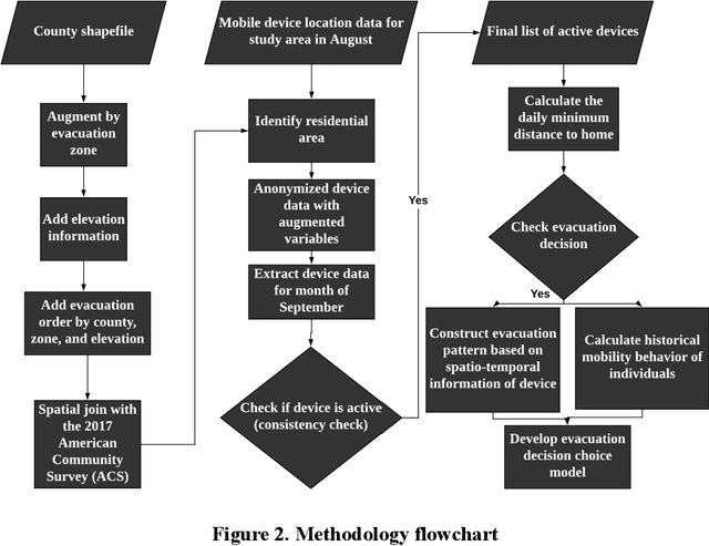

Abstract:Understanding individuals' behavior during hurricane evacuation is of paramount importance for local, state, and government agencies hoping to be prepared for natural disasters. Complexities involved with human decision-making procedures and lack of data for such disasters are the main reasons that make hurricane evacuation studies challenging. In this paper, we utilized a large mobile phone Location-Based Services (LBS) data to construct the evacuation pattern during the landfall of Hurricane Irma. By employing our proposed framework on more than 11 billion mobile phone location sightings, we were able to capture the evacuation decision of 807,623 smartphone users who were living within the state of Florida. We studied users' evacuation decisions, departure and reentry date distribution, and destination choice. In addition to these decisions, we empirically examined the influence of evacuation order and low-lying residential areas on individuals' evacuation decisions. Our analysis revealed that 57.92% of people living in mandatory evacuation zones evacuated their residences while this ratio was 32.98% and 33.68% for people living in areas with no evacuation order and voluntary evacuation order, respectively. Moreover, our analysis revealed the importance of the individuals' mobility behavior in modeling the evacuation decision choice. Historical mobility behavior information such as number of trips taken by each individual and the spatial area covered by individuals' location trajectory estimated significant in our choice model and improve the overall accuracy of the model significantly.
A Data-Driven Analytical Framework of Estimating Multimodal Travel Demand Patterns using Mobile Device Location Data
Dec 08, 2020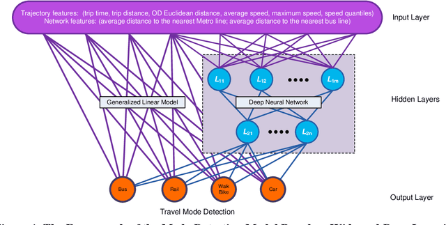
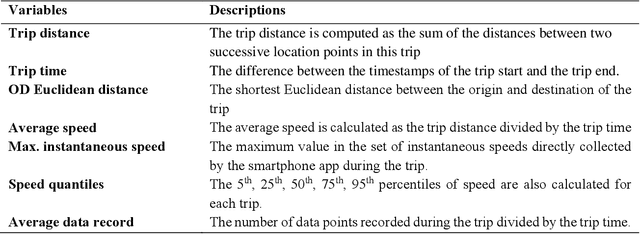
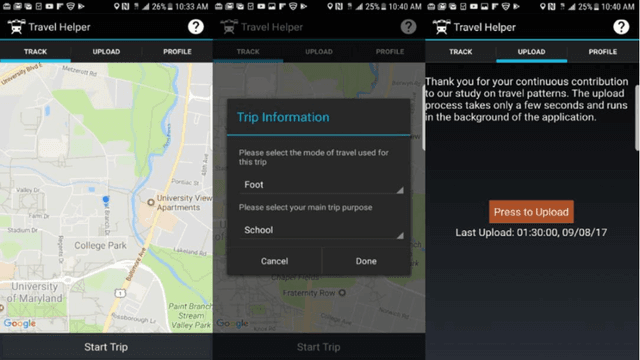
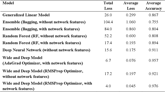
Abstract:While benefiting people's daily life in so many ways, smartphones and their location-based services are generating massive mobile device location data that has great potential to help us understand travel demand patterns and make transportation planning for the future. While recent studies have analyzed human travel behavior using such new data sources, limited research has been done to extract multimodal travel demand patterns out of them. This paper presents a data-driven analytical framework to bridge the gap. To be able to successfully detect travel modes using the passively collected location information, we conduct a smartphone-based GPS survey to collect ground truth observations. Then a jointly trained single-layer model and deep neural network for travel mode imputation is developed. Being "wide" and "deep" at the same time, this model combines the advantages of both types of models. The framework also incorporates the multimodal transportation network in order to evaluate the closeness of trip routes to the nearby rail, metro, highway and bus lines and therefore enhance the imputation accuracy. To showcase the applications of the introduced framework in answering real-world planning needs, a separate mobile device location data is processed through trip end identification and attribute generation, in a way that the travel mode imputation can be directly applied. The estimated multimodal travel demand patterns are then validated against typical household travel surveys in the same Washington D.C. and Baltimore Metropolitan Regions.
 Add to Chrome
 Add to Firefox
 Add to Edge