Richard Cloete
Improving the discovery of near-Earth objects with machine-learning methods
May 17, 2025Abstract:We present a comprehensive analysis of the digest2 parameters for candidates of the Near-Earth Object Confirmation Page (NEOCP) that were reported between 2019 and 2024. Our study proposes methods for significantly reducing the inclusion of non-NEO objects on the NEOCP. Despite the substantial increase in near-Earth object (NEO) discoveries in recent years, only about half of the NEOCP candidates are ultimately confirmed as NEOs. Therefore, much observing time is spent following up on non-NEOs. Furthermore, approximately 11% of the candidates remain unconfirmed because the follow-up observations are insufficient. These are nearly 600 cases per year. To reduce false positives and minimize wasted resources on non-NEOs, we refine the posting criteria for NEOCP based on a detailed analysis of all digest2 scores. We investigated 30 distinct digest2 parameter categories for candidates that were confirmed as NEOs and non-NEOs. From this analysis, we derived a filtering mechanism based on selected digest2 parameters that were able to exclude 20% of the non-NEOs from the NEOCP while maintaining a minimal loss of true NEOs. We also investigated the application of four machine-learning (ML) techniques, that is, the gradient-boosting machine (GBM), the random forest (RF) classifier, the stochastic gradient descent (SGD) classifier, and neural networks (NN) to classify NEOCP candidates as NEOs or non-NEOs. Based on digest2 parameters as input, our ML models achieved a precision of approximately 95% in distinguishing between NEOs and non-NEOs. Results. Combining the digest2 parameter filter with an ML-based classification model, we demonstrate a significant reduction in non-NEOs on the NEOCP that exceeds 80%, while limiting the loss of NEO discovery tracklets to 5.5%. Importantly, we show that most follow-up tracklets of initially misclassified NEOs are later correctly identified as NEOs.
Machine Learning Methods for Automated Interstellar Object Classification with LSST
Dec 03, 2024Abstract:The Legacy Survey of Space and Time, to be conducted with the Vera C. Rubin Observatory, is poised to revolutionize our understanding of the Solar System by providing an unprecedented wealth of data on various objects, including the elusive interstellar objects (ISOs). Detecting and classifying ISOs is crucial for studying the composition and diversity of materials from other planetary systems. However, the rarity and brief observation windows of ISOs, coupled with the vast quantities of data to be generated by LSST, create significant challenges for their identification and classification. This study aims to address these challenges by exploring the application of machine learning algorithms to the automated classification of ISO tracklets in simulated LSST data. We employed various machine learning algorithms, including random forests (RFs), stochastic gradient descent (SGD), gradient boosting machines (GBMs), and neural networks (NNs), to classify ISO tracklets in simulated LSST data. We demonstrate that GBM and RF algorithms outperform SGD and NN algorithms in accurately distinguishing ISOs from other Solar System objects. RF analysis shows that many derived Digest2 values are more important than direct observables in classifying ISOs from the LSST tracklets. The GBM model achieves the highest precision, recall, and F1 score, with values of 0.9987, 0.9986, and 0.9987, respectively. These findings lay the foundation for the development of an efficient and robust automated system for ISO discovery using LSST data, paving the way for a deeper understanding of the materials and processes that shape planetary systems beyond our own. The integration of our proposed machine learning approach into the LSST data processing pipeline will optimize the survey's potential for identifying these rare and valuable objects, enabling timely follow-up observations and further characterization.
Commissioning An All-Sky Infrared Camera Array for Detection Of Airborne Objects
Nov 12, 2024


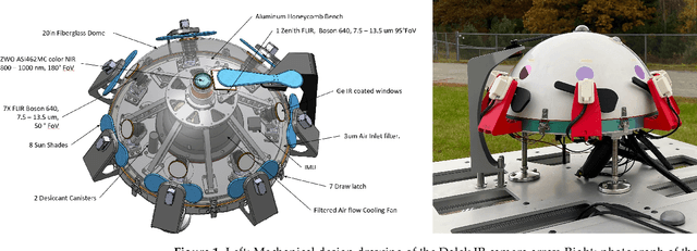
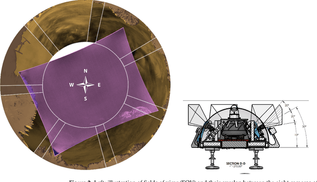
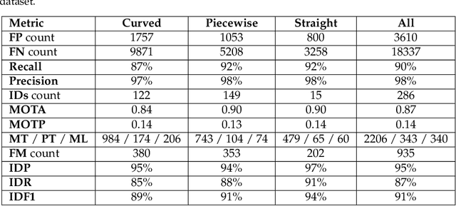
Abstract:To date there is little publicly available scientific data on Unidentified Aerial Phenomena (UAP) whose properties and kinematics purportedly reside outside the performance envelope of known phenomena. To address this deficiency, the Galileo Project is designing, building, and commissioning a multi-modal ground-based observatory to continuously monitor the sky and conduct a rigorous long-term aerial census of all aerial phenomena, including natural and human-made. One of the key instruments is an all-sky infrared camera array using eight uncooled long-wave infrared FLIR Boson 640 cameras. Their calibration includes a novel extrinsic calibration method using airplane positions from Automatic Dependent Surveillance-Broadcast (ADS-B) data. We establish a first baseline for the system performance over five months of field operation, using a real-world dataset derived from ADS-B data, synthetic 3-D trajectories, and a hand-labelled real-world dataset. We report acceptance rates (e.g. viewable airplanes that are recorded) and detection efficiencies (e.g. recorded airplanes which are successfully detected) for a variety of weather conditions, range and aircraft size. We reconstruct $\sim$500,000 trajectories of aerial objects from this commissioning period. A toy outlier search focused on large sinuosity of the 2-D reconstructed trajectories flags about 16% of trajectories as outliers. After manual review, 144 trajectories remain ambiguous: they are likely mundane objects but cannot be elucidated at this stage of development without distance and kinematics estimation or other sensor modalities. Our observed count of ambiguous outliers combined with systematic uncertainties yields an upper limit of 18,271 outliers count for the five-month interval at a 95% confidence level. This likelihood-based method to evaluate significance is applicable to all of our future outlier searches.
The Scientific Investigation of Unidentified Aerial Phenomena (UAP) Using Multimodal Ground-Based Observatories
May 31, 2023Abstract:(Abridged) Unidentified Aerial Phenomena (UAP) have resisted explanation and have received little formal scientific attention for 75 years. A primary objective of the Galileo Project is to build an integrated software and instrumentation system designed to conduct a multimodal census of aerial phenomena and to recognize anomalies. Here we present key motivations for the study of UAP and address historical objections to this research. We describe an approach for highlighting outlier events in the high-dimensional parameter space of our census measurements. We provide a detailed roadmap for deciding measurement requirements, as well as a science traceability matrix (STM) for connecting sought-after physical parameters to observables and instrument requirements. We also discuss potential strategies for deciding where to locate instruments for development, testing, and final deployment. Our instrument package is multimodal and multispectral, consisting of (1) wide-field cameras in multiple bands for targeting and tracking of aerial objects and deriving their positions and kinematics using triangulation; (2) narrow-field instruments including cameras for characterizing morphology, spectra, polarimetry, and photometry; (3) passive multistatic arrays of antennas and receivers for radar-derived range and kinematics; (4) radio spectrum analyzers to measure radio and microwave emissions; (5) microphones for sampling acoustic emissions in the infrasonic through ultrasonic frequency bands; and (6) environmental sensors for characterizing ambient conditions (temperature, pressure, humidity, and wind velocity), as well as quasistatic electric and magnetic fields, and energetic particles. The use of multispectral instruments and multiple sensor modalities will help to ensure that artifacts are recognized and that true detections are corroborated and verifiable.
* This paper is published in the Journal of Astronomical Instrumentation, 12(1), 2340006 (2023) https://doi.org/10.1142/S2251171723400068
SkyWatch: A Passive Multistatic Radar Network for the Measurement of Object Position and Velocity
May 31, 2023


Abstract:(Abridged) Quantitative three-dimensional (3D) position and velocity estimates obtained by passive radar will assist the Galileo Project in the detection and classification of aerial objects by providing critical measurements of range, location, and kinematics. These parameters will be combined with those derived from the Project{\textquoteright}s suite of electromagnetic sensors and used to separate known aerial objects from those exhibiting anomalous kinematics. SkyWatch, a passive multistatic radar system based on commercial broadcast FM radio transmitters of opportunity, is a network of receivers spaced at geographical scales that enables estimation of the 3D position and velocity time series of objects at altitudes up to 80km, horizontal distances up to 150km, and at velocities to {\textpm}2{\textpm}2km/s ({\textpm}6{\textpm}6Mach). The receivers are designed to collect useful data in a variety of environments varying by terrain, transmitter power, relative transmitter distance, adjacent channel strength, etc. In some cases, the direct signal from the transmitter may be large enough to be used as the reference with which the echoes are correlated. In other cases, the direct signal may be weak or absent, in which case a reference is communicated to the receiver from another network node via the internet for echo correlation. Various techniques are discussed specific to the two modes of operation and a hybrid mode. Delay and Doppler data are sent via internet to a central server where triangulation is used to deduce time series of 3D positions and velocities. A multiple receiver (multistatic) radar experiment is undergoing Phase 1 testing, with several receivers placed at various distances around the Harvard{\textendash}Smithsonian Center for Astrophysics (CfA), to validate full 3D position and velocity recovery.
* This paper is published in the Journal of Astronomical Instrumentation, 12(1) (2023) 10.1142/S2251171723400044 The abstract has been updated
Multi-Band Acoustic Monitoring of Aerial Signatures
May 29, 2023Abstract:The Galileo Project's acoustic monitoring, omni-directional system (AMOS) aids in the detection and characterization of aerial phenomena. It uses a multi-band microphone suite spanning infrasonic to ultrasonic frequencies, providing an independent signal modality for validation and characterization of detected objects. The system utilizes infrasonic, audible, and ultrasonic systems to cover a wide range of sounds produced by both natural and man-made aerial phenomena. Sound signals from aerial objects can be captured given certain conditions, such as when the sound level is above ambient noise and isn't excessively distorted by its transmission path. Findings suggest that audible sources can be detected up to 1 km away, infrasonic sources can be detected over much longer distances, and ultrasonic at shorter ones. Initial data collected from aircraft recordings with spectral analysis will help develop algorithms and software for quick identification of known aircraft. Future work will involve multi-sensor arrays for sound localization, larger data sets analysis, and incorporation of machine learning and AI for detection and identification of more types of phenomena in all frequency bands.
A Hardware and Software Platform for Aerial Object Localization
May 29, 2023Abstract:To date, there are little reliable data on the position, velocity and acceleration characteristics of Unidentified Aerial Phenomena (UAP). The dual hardware and software system described in this document provides a means to address this gap. We describe a weatherized multi-camera system which can capture images in the visible, infrared and near infrared wavelengths. We then describe the software we will use to calibrate the cameras and to robustly localize objects-of-interest in three dimensions. We show how object localizations captured over time will be used to compute the velocity and acceleration of airborne objects.
 Add to Chrome
 Add to Firefox
 Add to Edge