Panchamy Krishnakumari
A data-driven approach to predict decision point choice during normal and evacuation wayfinding in multi-story buildings
Aug 07, 2023Abstract:Understanding pedestrian route choice behavior in complex buildings is important to ensure pedestrian safety. Previous studies have mostly used traditional data collection methods and discrete choice modeling to understand the influence of different factors on pedestrian route and exit choice, particularly in simple indoor environments. However, research on pedestrian route choice in complex buildings is still limited. This paper presents a data-driven approach for understanding and predicting the pedestrian decision point choice during normal and emergency wayfinding in a multi-story building. For this, we first built an indoor network representation and proposed a data mapping technique to map VR coordinates to the indoor representation. We then used a well-established machine learning algorithm, namely the random forest (RF) model to predict pedestrian decision point choice along a route during four wayfinding tasks in a multi-story building. Pedestrian behavioral data in a multi-story building was collected by a Virtual Reality experiment. The results show a much higher prediction accuracy of decision points using the RF model (i.e., 93% on average) compared to the logistic regression model. The highest prediction accuracy was 96% for task 3. Additionally, we tested the model performance combining personal characteristics and we found that personal characteristics did not affect decision point choice. This paper demonstrates the potential of applying a machine learning algorithm to study pedestrian route choice behavior in complex indoor buildings.
Crowd Safety Manager: Towards Data-Driven Active Decision Support for Planning and Control of Crowd Events
Jul 31, 2023Abstract:This paper presents novel technology and methodology aimed at enhancing crowd management in both the planning and operational phases. The approach encompasses innovative data collection techniques, data integration, and visualization using a 3D Digital Twin, along with the incorporation of artificial intelligence (AI) tools for risk identification. The paper introduces the Bowtie model, a comprehensive framework designed to assess and predict risk levels. The model combines objective estimations and predictions, such as traffic flow operations and crowdedness levels, with various aggravating factors like weather conditions, sentiments, and the purpose of visitors, to evaluate the expected risk of incidents. The proposed framework is applied to the Crowd Safety Manager project in Scheveningen, where the DigiTwin is developed based on a wealth of real-time data sources. One noteworthy data source is Resono, offering insights into the number of visitors and their movements, leveraging a mobile phone panel of over 2 million users in the Netherlands. Particular attention is given to the left-hand side of the Bowtie, which includes state estimation, prediction, and forecasting. Notably, the focus is on generating multi-day ahead forecasts for event-planning purposes using Resono data. Advanced machine learning techniques, including the XGBoost framework, are compared, with XGBoost demonstrating the most accurate forecasts. The results indicate that the predictions are adequately accurate. However, certain locations may benefit from additional input data to further enhance prediction quality. Despite these limitations, this work contributes to a more effective crowd management system and opens avenues for further advancements in this critical field.
Day-to-day and seasonal regularity of network passenger delay for metro networks
Jul 07, 2021


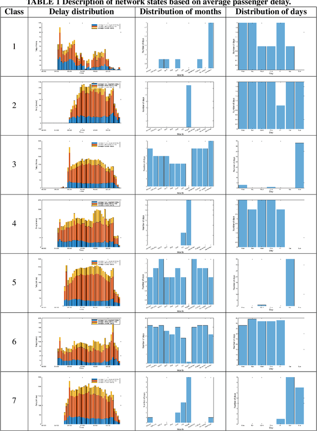
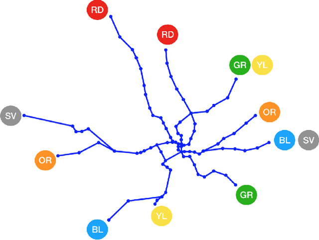
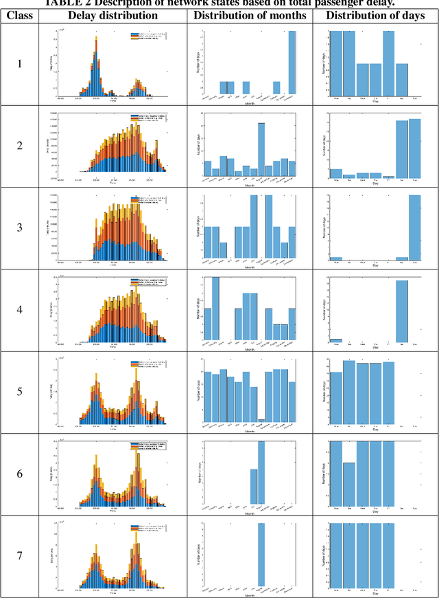
Abstract:In an effort to improve user satisfaction and transit image, transit service providers worldwide offer delay compensations. Smart card data enables the estimation of passenger delays throughout the network and aid in monitoring service performance. Notwithstanding, in order to prioritize measures for improving service reliability and hence reducing passenger delays, it is paramount to identify the system components - stations and track segments - where most passenger delay occurs. To this end, we propose a novel method for estimating network passenger delay from individual trajectories. We decompose the delay along a passenger trajectory into its corresponding track segment delay, initial waiting time and transfer delay. We distinguish between two different types of passenger delay in relation to the public transit network: average passenger delay and total passenger delay. We employ temporal clustering on these two quantities to reveal daily and seasonal regularity in delay patterns of the transit network. The estimation and clustering methods are demonstrated on one year of data from Washington metro network. The data consists of schedule information and smart card data which includes passenger-train assignment of the metro network for the months of August 2017 to August 2018. Our findings show that the average passenger delay is relatively stable throughout the day. The temporal clustering reveals pronounced and recurrent and thus predictable daily and weekly patterns with distinct characteristics for certain months.
 Add to Chrome
 Add to Firefox
 Add to Edge