Nikunj Oza
Improving Variational Autoencoder using Random Fourier Transformation: An Aviation Safety Anomaly Detection Case-Study
Jan 03, 2026Abstract:In this study, we focus on the training process and inference improvements of deep neural networks (DNNs), specifically Autoencoders (AEs) and Variational Autoencoders (VAEs), using Random Fourier Transformation (RFT). We further explore the role of RFT in model training behavior using Frequency Principle (F-Principle) analysis and show that models with RFT turn to learn low frequency and high frequency at the same time, whereas conventional DNNs start from low frequency and gradually learn (if successful) high-frequency features. We focus on reconstruction-based anomaly detection using autoencoder and variational autoencoder and investigate the RFT's role. We also introduced a trainable variant of RFT that uses the existing computation graph to train the expansion of RFT instead of it being random. We showcase our findings with two low-dimensional synthetic datasets for data representation, and an aviation safety dataset, called Dashlink, for high-dimensional reconstruction-based anomaly detection. The results indicate the superiority of models with Fourier transformation compared to the conventional counterpart and remain inconclusive regarding the benefits of using trainable Fourier transformation in contrast to the Random variant.
Deep Transfer Learning on Satellite Imagery Improves Air Quality Estimates in Developing Nations
Feb 17, 2022


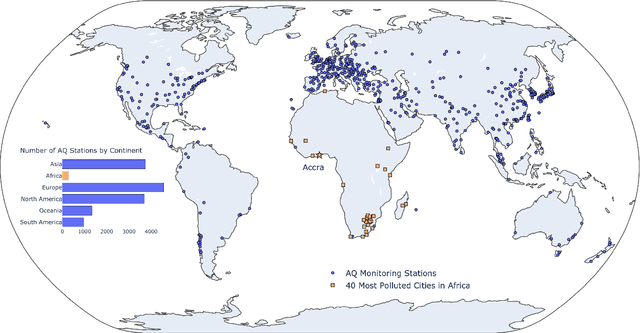
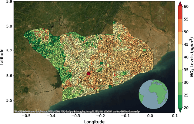
Abstract:Urban air pollution is a public health challenge in low- and middle-income countries (LMICs). However, LMICs lack adequate air quality (AQ) monitoring infrastructure. A persistent challenge has been our inability to estimate AQ accurately in LMIC cities, which hinders emergency preparedness and risk mitigation. Deep learning-based models that map satellite imagery to AQ can be built for high-income countries (HICs) with adequate ground data. Here we demonstrate that a scalable approach that adapts deep transfer learning on satellite imagery for AQ can extract meaningful estimates and insights in LMIC cities based on spatiotemporal patterns learned in HIC cities. The approach is demonstrated for Accra in Ghana, Africa, with AQ patterns learned from two US cities, specifically Los Angeles and New York.
Semi-Markov Switching Vector Autoregressive Model-based Anomaly Detection in Aviation Systems
Feb 28, 2016


Abstract:In this work we consider the problem of anomaly detection in heterogeneous, multivariate, variable-length time series datasets. Our focus is on the aviation safety domain, where data objects are flights and time series are sensor readings and pilot switches. In this context the goal is to detect anomalous flight segments, due to mechanical, environmental, or human factors in order to identifying operationally significant events and provide insights into the flight operations and highlight otherwise unavailable potential safety risks and precursors to accidents. For this purpose, we propose a framework which represents each flight using a semi-Markov switching vector autoregressive (SMS-VAR) model. Detection of anomalies is then based on measuring dissimilarities between the model's prediction and data observation. The framework is scalable, due to the inherent parallel nature of most computations, and can be used to perform online anomaly detection. Extensive experimental results on simulated and real datasets illustrate that the framework can detect various types of anomalies along with the key parameters involved.
 Add to Chrome
 Add to Firefox
 Add to Edge