Mina Farmanbar
MultiConAD: A Unified Multilingual Conversational Dataset for Early Alzheimer's Detection
Feb 26, 2025Abstract:Dementia is a progressive cognitive syndrome with Alzheimer's disease (AD) as the leading cause. Conversation-based AD detection offers a cost-effective alternative to clinical methods, as language dysfunction is an early biomarker of AD. However, most prior research has framed AD detection as a binary classification problem, limiting the ability to identify Mild Cognitive Impairment (MCI)-a crucial stage for early intervention. Also, studies primarily rely on single-language datasets, mainly in English, restricting cross-language generalizability. To address this gap, we make three key contributions. First, we introduce a novel, multilingual dataset for AD detection by unifying 16 publicly available dementia-related conversational datasets. This corpus spans English, Spanish, Chinese, and Greek and incorporates both audio and text data derived from a variety of cognitive assessment tasks. Second, we perform finer-grained classification, including MCI, and evaluate various classifiers using sparse and dense text representations. Third, we conduct experiments in monolingual and multilingual settings, finding that some languages benefit from multilingual training while others perform better independently. This study highlights the challenges in multilingual AD detection and enables future research on both language-specific approaches and techniques aimed at improving model generalization and robustness.
Precision in Building Extraction: Comparing Shallow and Deep Models using LiDAR Data
Sep 21, 2023


Abstract:Building segmentation is essential in infrastructure development, population management, and geological observations. This article targets shallow models due to their interpretable nature to assess the presence of LiDAR data for supervised segmentation. The benchmark data used in this article are published in NORA MapAI competition for deep learning model. Shallow models are compared with deep learning models based on Intersection over Union (IoU) and Boundary Intersection over Union (BIoU). In the proposed work, boundary masks from the original mask are generated to improve the BIoU score, which relates to building shapes' borderline. The influence of LiDAR data is tested by training the model with only aerial images in task 1 and a combination of aerial and LiDAR data in task 2 and then compared. shallow models outperform deep learning models in IoU by 8% using aerial images (task 1) only and 2% in combined aerial images and LiDAR data (task 2). In contrast, deep learning models show better performance on BIoU scores. Boundary masks improve BIoU scores by 4% in both tasks. Light Gradient-Boosting Machine (LightGBM) performs better than RF and Extreme Gradient Boosting (XGBoost).
Satellite image classification methods and Landsat 5TM bands
Aug 08, 2013


Abstract:This paper attempts to find the most accurate classification method among parallelepiped, minimum distance and chain methods. Moreover, this study also challenges to find the suitable combination of bands, which can lead to better results in case combinations of bands occur. After comparing these three methods, the chain method over perform the other methods with 79% overall accuracy. Hence, it is more accurate than minimum distance with 67% and parallelepiped with 65%. On the other hand, based on bands features, and also by combining several researchers' findings, a table was created which includes the main objects on the land and the suitable combination of the bands for accurately detecting of landcover objects. During this process, it was observed that band 4 (out of 7 bands of Landsat 5TM) is the band, which can be used for increasing the accuracy of the combined bands in detecting objects on the land.
3-SAT Problem A New Memetic-PSO Algorithm
Jun 21, 2013


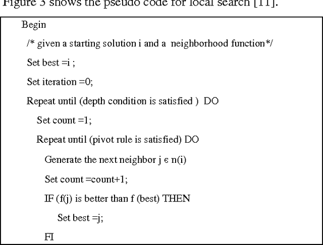
Abstract:3-SAT problem is of great importance to many technical and scientific applications. This paper presents a new hybrid evolutionary algorithm for solving this satisfiability problem. 3-SAT problem has the huge search space and hence it is known as a NP-hard problem. So, deterministic approaches are not applicable in this context. Thereof, application of evolutionary processing approaches and especially PSO will be very effective for solving these kinds of problems. In this paper, we introduce a new evolutionary optimization technique based on PSO, Memetic algorithm and local search approaches. When some heuristics are mixed, their advantages are collected as well and we can reach to the better outcomes. Finally, we test our proposed algorithm over some benchmarks used by some another available algorithms. Obtained results show that our new method leads to the suitable results by the appropriate time. Thereby, it achieves a better result in compared with the existent approaches such as pure genetic algorithm and some verified types
 Add to Chrome
 Add to Firefox
 Add to Edge